ALLEN'S ILLUSTRATED
GUIDE TO NOTTINGHAM
THAT Nottingham existed at a very remote period there cannot be a doubt. Situated at the terminus of an extensive Forest, and on the banks of the river Trent (the third river in magnitude in the kingdom), with a fertile pasturage all around, and on an elevation eminently calculated for war and defence, few sites could be found more tempting in the country. It may therefore be assumed, that a town of some description existed here prior to the birth of Christ, and indeed anterior to the Roman invasion. Rowse gives Nottingham an antiquity so far back as 980 years before the Christian era, but on what evidence is not known. One thing is certain, that the soft and easily excavated sandstone rock was utilized to form dwellings in early times, many of which were inhabited until a recent period, and a few remain until the present day. The Saxon invaders gave to this place the name of Snodengaham or Snottingham, meaning a habitation or retreat in the rocks. To pursue the early History of the town further, would occupy more space than our limits will permit; we therefore pass on to the consideration of Nottingham as it now is.
Nottingham is the county town of Nottinghamshire; is one of the nineteen places constituted counties by Royal Charter; is a municipal borough of sixteen wards, and a Parliamentary borough. It is also an Assize and market town, and an Union. Nottingham is located a little to the south-east of the centre of England, and is bounded on the north by Hucknall Torkard (the burial place of Byron), on the east by Bestwood, Arnold, a portion of Gedling, and Colwick, on the south by West Bridgford and Wilford, and on the west by Wollaton, Bilborough, Beeston, and Nuthall. It is distant from London 124 miles, from Birmingham 54 miles, from Manchester 75 miles, from Liverpool 100 miles, from Lincoln 33 miles, and from Leicester 27 miles. The borough (which covers an area of 9,960 acres, or about 15 square miles) includes the parishes of Lenton, Radford, Basford, Bulwell, Sneinton, and parts of Wilford and Gedling. On the north it is sheltered by a range of hills, but is open on the south to the Nottinghamshire Wolds, the Vale of Belvoir, and the Leicestershire hills. Nottingham shows a very satisfactory bill of health, and has an excellent water supply. Taken altogether it is one of the cleanest, healthiest, and most pleasant manufacturing towns in the United Kingdom.
The population of Nottingham approaches 253,000. The rainfall averages about 29 inches. The rateable value exceeds £920,030. The staple trades are lace and hosiery, but silk, cotton, and woollen yarn is spun and twisted here. Tanning, brewing, and malting are carried on in the town and its neighbourhood; and there are many engineering works and foundries. Nottingham is governed by a Mayor, sixteen Aldermen, and forty-eight Councillors; has a Sheriff and a Recorder, and elects three Members of Parliament. The market days are Wednesday and Saturday.
There are two central Railway Stations* and several district stations in the borough, on the Great Northern and Midland Railways. Both Central Stations are situate in Station-street. For the purposes of this Guide, it must be assumed that visitors have arrived in Station-street. The Great Northern Station is a terminus, and was opened October 2, 1857; and the Midland Station May 22, 1848. The first section of the Tramways was opened September 17, 1878.
Visitors must now determine, according to circumstances and taste, whether they wish to enter the heart of the commercial portion of Nottingham, or whether they will devote half an hour or more before doing so. If the former is the case, visitors should take a tram which starts between the two stations every five minutes (fare 1d.), and runs close to the Market-place, and within a few minutes' walk of the Castle, the University College, Free Public Library, Natural History Museum, and Arboretum. They should then follow the Guide near the bottom of page 12.
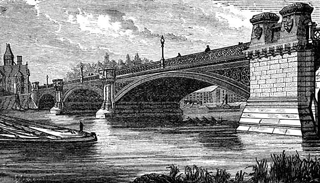
THE TRENT BRIDGE.
Assuming, however, that visitors have time at their disposal, and desire to visit the Trent before entering "the town," they should take a ten minutes' walk by the London-road route—the road between the two stations—which leads direct to the Trent Bridge. The Corporation Sanitary Depot and the Cattle Market (opened Sep. 28th, 1886) occupy a large tract of land on the left-hand side of London-road, known as "The East-croft." They are divided from the roadway by the canal, and approached by three bridges. The Trent Bridge, which crosses the river (and is, generally speaking, the south boundary of the borough of Nottingham), is an elegant and substantial iron structure of three graceful spans, and was opened in 1871. It occupies a position a few yards to the east of the fine old many-arched stone bridge, which crossed the river here for several centuries. Part of the old bridge has been preserved to us, and is crossed by the pathway (against the Police Lodge) which leads to the south river walk. The history of the bridge has been written by the writer of this Guide, and by other local antiquaries. On the left-hand, approached by steps, are tastefully laid-out grounds, and a river-wall promenade. From the steam packet station here, pleasant trips to and from Colwick Park are made during suitable weather, at small cost. Before crossing the bridge, visitors should view the prospect afforded by water, landscape, and town. Opposite the river-wall promenade is Radford's Boating House.
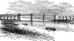
RAILWAY BRIDGE CROSSING THE TRENT.
A little down the river the railway crosses the Trent by a bridge, of which an illustration is given. At the country (West Bridgford) end of the bridge is the far-famed Trent Bridge Cricket Ground, upon which many a struggle for victory has taken place with bat and football. The handsome pavilion is to be seen from the Nottingham side of the river. The country inn here has been recently demolished, and a more pretentious and convenient building has been erected in its place.
On the upper reaches of the river are the Baths, maintained at the cost of the ratepayers, and available without charge. Beyond them is the Wilford Bridge, a substantial iron structure, with brick and stone approaches, which was thrown open to the public, on payment of toll, June 16, 1870; and Wilford Church, a favourite spot of Henry Kirke White, who expressed a wish to be interred here—
"Here would I wish to sleep. This is the spot Which I have long marked out to lay my bones in; Tired out and wearied with the riotous world, Beneath this yew I would be sepulchred."
But his wish was not complied with, as that promising poet was buried at St. John's, Cambridge. Visitors will not, however, have time to visit Wilford—a pretty rural village—if the centre of the old town is to be traversed. Visitors who have time to do so should not miss the opportunity of making a half-day holiday at Wilford, with the cottage ever to be associated with Kirke White; and the far-famed Clifton Grove, with its legend of "The Fair Maid of Clifton," as told by Kirke White. The district between the stations and the river retains its name of "The Meadows," and is still subject to floods.
* The Midland Railway between Nottingham and Derby was opened May 80, 1839; the Nottingham and Lincoln, August 8, 1846; Nottingham and Grantham, July 18, 1860; and the Nottingham and Melton (Gt. Nor.), September 1, 1879.