< Previous | Contents | Next >
GEOLOGY.
The prosperity of Hucknall during the last half-century has been mainly due to the existence and working of the mineral treasures beneath the parish. It is therefore fitting that a brief description of the strata should be given in this book.
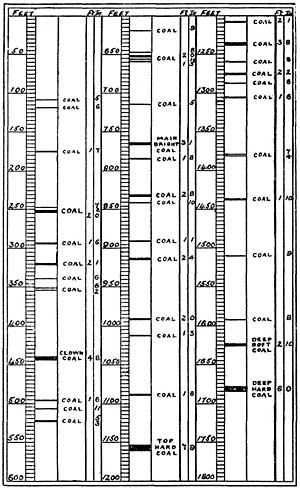
Section at Strata Underlying Hucknall, Showing the Coal Measures.
The crust of the globe on which the parish stands has been subjected to many changes during the cooling process of the earth. The coal measures axe nearly 3,000 feet thick, and there are at least forty distinct seams of coal, varying in thickness from about an inch to six feet. Each seam represents a change in the level of the ground, sometimes caused by a subsidence and a gathering of water, and sometimes by an upheaval of the surrounding land; the vegetation beneath the water became carbonised and was covered by deposits of sand and mud. The vegetation became coal, and the sand and mud became stone and clay.
In later ages a thick covering of the Bunter Red Sandstone covered the valley of the Leen. Remnants of this sandstone strata are to be seen on the Bestwood and Papplewick hills to the north and east, and the Long Hills in Hucknall form a spur of the Robin Hood hills, a portion of the vast bed of sandstone which stretches from Doncaster to the Trent. The valley was scooped out, mainly by the action of water before the glacial period.
The sinkers of No. 1 Colliery had to penetrate about 35 yards of hard strata (chiefly limestone) before they found the first seam of coal, which was 41/2 inches thick. They delved down 260 yards, and passed through seventeen seams of coal before they reached the Main Bright measure which is now being worked, and which is some 20 yards above the seam known as the High Hazel.
The Top Hard seam was found at a depth of 387 yards—a fine bed, comprising 1ft. 9ins. of coomb coal; 2ins. of bat; 3ft. 9ins. of best hard; 2ins. of stone; and 1ft. 10ins. of cannel coal. Of these varieties of coal the section which is known commercially as "Best Hard" has proved the most valuable as a steam raiser and for household purposes.
Chemically, the various coals differ in percentage of carbon. The average in cannel (candle) coal is 72.20 per cent., in bituminous coal it is 81.56 per cent., in steam coal 89.86 per cent., and in anthracite 91.13 per cent.
A great geologist has shown that the alternating bright and dull layers of many coals, such as the Top Hard, are characterised respectively by the abundance of the bright particles which are composed of cortical cells, ligneous tissues, fragments of leaves, spore cases, and amorphous carbonaceous material, while the dull portion is composed of foliar tissues, epidermal membranes, with muddy and sandy material.
The formation of cannel coal has been a puzzle to geologists. One theory was that it was composed of fern spores, but a more reasonable description of its origin is given in the "Victorian History," viz., that its indefinite structure is probably due to the decomposition of ordinary coal and its deposition as a water-borne sediment. The first cannel produced at Hucknall caused much interest. It was found to contain oil, and for a time a little plant was installed by the side of the railway near Farley Lane for extracting this. Leen Valley cannel is also a good gas producer, and huge quantities have been used at gasworks in London, Manchester, Sheffield, and elsewhere.
Cannel differs in many ways from other coals, and often contains fossil fish, shells, &c, which others practically never do.
It is also characterised even to a greater extent than bituminous coal by containing abundant spores of plants. These are eminently resinous bodies; hence the great amount of flame and smoke made by these two classes of coal.
The sinkers passed through 12 seams below the Top Hard before they struck the Deep Soft, and 18 yards lower they found the Deep Hard. The strata between the coal beds consists almost entirely of bind, ironstone, fire-clay, and black shale.
There is only one place in Hucknall where a coal seam has been exposed to daylight. This is at the spot where the Great Central bridge spans the Town Brook in the valley west of Spring Street, and on the edge of the great fault which intersects the parish. The navvies when digging for the bridge foundations struck through a thin seam of coal.
A gang of navvies who were excavating the Great Central cutting exposed the channel of an ancient river about 20 yards south of Wood Lane bridge. The river had apparently been about 20 feet wide and ran east, in the direction of the Leen.
The Magnesian Limestone which forms the greater part of the surface strata in the parish was at first a sand deposit at the bottom of a large shallow lake or lagoon of almost still water, much impregnated with carbonate magnesia, carbonate of lime, with a mixture of Epsom salts and plaster of Paris. Magnesia ia extracted for commercial purposes from similar stone. Very few fossils are found in the district, the most frequent being the shells, trees, and ferns common to coal measures.
The gravel deposits on the Tenter Hill contain many Yorkshire flints, fragments of marble and granite, and unmistakably show that a great glacier travelled at one period from the icy north over Yorkshire, perhaps 100,000 years ago, and as the ice melted the broken rock fragments and sand were deposited hereabouts. Subsequently another glacier passed over Hucknall, as is indicated by the disturbed deposits of the earlier glacier.
The hill on which Sandy-lane windmill stands is formed by the great "fault" or upheaval of strata, and extends for miles. Near where the Watnall Road crosses this fault the limestone once formed an arch, and was capped with red marl and clay, but the top of the arch was carved away ages ago, and the limestone is left standing end up to the surface.
The chief water-bearing strata in the parish is found in the sand hills, north of the Common, where the Whyburn and Granger's springs issue and flow through the town. In the neighbourhood of the Longhills several huge boulders of conglomerates have been found, relics of an ancient sea-shore. These boulders consist of pebbles cemented in a matrix of red sand, with peroxide of iron and are as hard as flint. Bands of this conglomerate have been traced as far west as Morley in Derbyshire. A boulder of tough volcanic ash lies by the stream side in the meadow below Mr. Brackner's farmhouse, at Whyburn.
Hucknall presents a good field of enquiry for the geologist because of its varied surface features, and the fund of information yielded by the local colliery sinkings increases interest in that delightful study.