< Previous | Contents | Next >
CHAPTER II.
East Leake in Domesday Book.
Domesday Book.—“the Book of Judicial Verdict”—was compiled between the years 1080-1086, at the instance of William the Conqueror. It records a survey made with the object of finding out what customary payments had been paid to the Crown by the manors. The Commissioners entrusted with this work came into the Hundred divisions of the counties, and empanelled juries, who on oath gave information as to the extent and nature of the estates, what sums were payable to the Crown before and after the Conquest, with other particulars which a transcript of the entries concerning Leake will illustrate.
It may be assumed that the jury which gave the necessary particulars of this Hundred met the royal commissioners at Court Hill. The records of that meeting so far as they concern the village of Leake are as follows:—
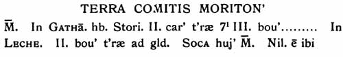
LAND OF THE COUNT OF MORETON.2
Manor.—In Gotham Stori had two carucates of land and three bovates and a half of taxable land. . . . . In Leake there are two bovates of taxable land.3 Soke of this manor.4 There is nothing there.5
This land plainly lay on the Gotham side of the parish.
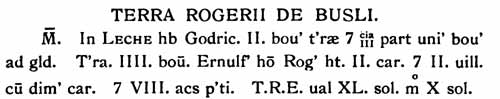
LAND OF ROGER DE BUSLI.6
In Leake Godric had two bovates of land, and the third part of one bovate of taxable land. There is land for four oxen. Ernulf, Roger’s man (tenant) has two carucates, and two villeins6 with half a carucate, and eight acres of meadow.
In King Edward’s7 time the value was forty shillings, it is now ten shillings.8
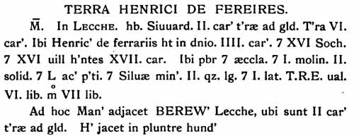
LAND OF HENRY DE FERRERS.
Manor.—In Leake Siward had two carucates of taxable land. There is land for six ploughs. There Henry de Ferrers has in demesne four carucates, and sixteen sokemen,10 and sixteen villeins having seventeen carucates. There is a priest, and a church, and one mill worth two shillings (per annum), and fifty acres of meadow, and underwood two roods (quarters) long and one broad. In King Edward’s time it was worth six pounds, now seven pounds.
To this manor Berewick11 (or Borough or Barrow) Lecche (Leake) is adjacent, where are two carucates of taxable land. This lies in Plumtree Hundred.12
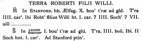
Manor.—In Stanford AElfage had ten bovates of taxable land. There are four carucates of plough land. There Robert son of William has one carucate and four sokemen and seven villeins.
Soke.—In Stanton belonging to Leake there is one bovate of taxable land. There are four bovates of plough land. There two sokemen have one carucate. It belongs to Stanford.13
Assuming that the area of the Domesday parish of Leake is the same as that of East and West Leake of to-day, it amounted to about 4,130 acres. 3,090 were thus under cultivation, and there were fifty-eight acres of meadow land. The remaining 982 acres were waste and unreclaimed. Some of this land remained in this condition until the Enclosure. This record shews that a much larger area was under cultivation after than before the Conquest.
The population as enumerated is only thirty-six, but it may be taken for granted that these thirty-six, with the possible exception of the priest, were heads of houses. If the moderate number of five persons to a household be assumed, the actual population was 180.
Only one of these is named, Ernulph, the Steward of Roger de Busli.
It is plain enough that there was only one Leake in 1086, and one church. Was this East or West Leake ? It will have been observed that there is a sort of appendix to the most important of the four entries about Leake in the Domesday Book. In this entry BEREW’ LECCHE is mentioned. If this can be identified, then LECCHE can also be identified, for it is described as adjacent, or near to it.
Usually BEREW’ is the short form of Berewick, an outlying farm belonging to a manor, and it is prefixed in the margin of Domesday with B as manor is prefixed by M. In this instance there is no prefix, giving ground for thinking that it means Barrow or Borough. Whichever interpretation is given, this place must be located on the East side of the parish, for it was in Plumtree Hundred—a Hundred now absorbed in Rushcliff—and Plumtree is more or less East of Leake. At the East end of East Leake at the bottom of Castle Lane and Back Yard there was, down to the middle of the 19th century, a pool known as Borough Pool; this agrees with the location of BEREW' LECCHE in the East of the parish. If the “ Borough ’’ interpretation of the word BEREW' is correct, this Site East of East Leake would be made sure, for in the field nearest to Borough Pool is an extensive well- defined earthwork, which may be regarded as part an ancient burh or fortified enclosure.
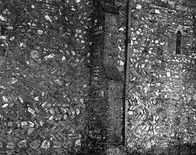
NORTH WALL OF CHURCH, WITH HERRING-BONE WORK AND SMALL WINDOW.
The geographical note of Domesday Book combined with this pool name gives a strong presumption in favour of locating BEREW’ LECCHE at the “Castle” end of the village of East Leake. If this may be assumed, LECCHE must be located near enough to be described as “adjacent.’* The West or Church end of East Leake, one-third mile distant, corresponds with this term. West Leake certainly does not, being two miles away.
This identification of East Leake with the LECCHE of Domesday Book is confirmed by other evidence.
- In the manor history it is found that Earl Robert Ferrers, third of his line, disposed of the manor of West Leake to a family named Touk, and that village is called “ de Touk’s Leake ” in contrast to “ Earl Ferrers* Leake, where the mother church is.” This certainly appears to locate the mother church—and consequently parish—at East Leake.
- The church at East Leake is thought by some archaeologists to have Saxon work in the North wall. If this is correct, we have immediate proof that this is the church of Domesday Book, and that the village there described is the village of East Leake.
- As early as 1280 East Leake was known as Great Leke, a name which suggests a parent rather than a daughter village.
The “wood” of Domesday cannot be traced, but its direction can be told, for the name of the Normanton-road— “Woodgate”—gives it. “Wood” is Saxon in origin. “Gate” is Danish for way or street, so Woodgate is the way to the wood. The wood must therefore have been situated at some little distance South South-East of the village.
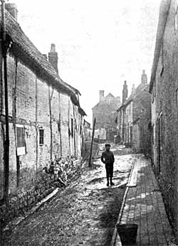 BACK YARD.
The mill mentioned in the same record cannot with certainty be located. It may possibly have stood on the West side of the little brook at the point where the Bunny footpath diverges from that to Gotham, where foundations of a building are still visible, together with traces of ancient walling on the East side. In those days all buildings would be, as far as possible, within the mound or fortification which surrounded each Saxon village.
The name Leake has passed through many changes in form—Leche, Lecche, Leca and Leica (Latin forms), Lee, Lek, Leyk, Leyke, Leke, Leek, Leak, and lastly Leake. It will be observed from this list that the long E sound has triumphed over the short E sound.
The names of the two separate parishes appear in this sequence, Earl Ferrers Leche and Jordan de Toc’s Leke, Ester Leke and Wester Leke. Great Leyke and Little Leyke, and lastly East Leake and West Leake.
Variants, such as Est and Easter14 Leke, are met with. It is still not uncommon to meet with those who speak of Great and Little Leake.
With a railway station, and a post and telegraph office, the spelling may be considered as finally fixed.

(1) 7 is the sign for &, and not for seven.
(2) The Count of Moreton or Moretain was Robert, half-brother of William I.
(3) A carucate of land was as much as eight oxen could plough, and was generally 120 acres. A bovate was as much as one ox could plough, an eighth of a carucate.
(4) Soke means outlying property dependent upon the manor.
(5) “There is nothing there” probably means none of the required particulars.
(6) Roger de Busli’s male line ended in 1213, when Idonea, daughter and heir of his grandson, married Robert de Vipont, a baron adhering to King John, who died 12 Henry III. She died 25 Henry III. Her grandson was the last of his race.
(7) Villeins were men bred and born in the village of servile condition, who were regarded as belonging to the land.
(8) King Edward, the Confessor, the last Saxon King.
(9) This land lay in East Leake.
(10) Sokemen were tenants bound to certain services to their lord.
(11) If Berew’ is Berewick it means an outlying farm, if Borough it may refer to a Burh, or fortified place. It may stand for Barrow, a burial mound.
(12) This land lay chiefly in East Leake, but included West Leake.
(13) This entry seems to refer to Stanton in Leicestershire, now Staunton Harold, with which place Leake was connected by ties of ownership.
(14) Isaac Taylor, in“ Words and Places,” places “ Easterleake in Notts” among those places whose names may have been derived from Eostre (whence our word Easter) the Anglo-Saxon goddess of spring. This is plainly an error which local knowledge would have avoided.