< Previous | Contents | Next >
CHAPTER V.
GIVES PARTICULARS OF INTEREST CONCERNING THE NEIGHBOURING VILLAGES AND PLACES OF ATTRACTION.
AS is the case in all districts of the Homeland, many of the villages around Retford possess rural attractions, historic associations, and ancient and interesting churches. There follow particulars of some best worth visiting and most accessible. Quiet and peaceful, surrounded by orchards, meadowlands and cornfields, they remain much as they were centuries ago. Many have not yet been reached by the railway. The occupations are unchanged: mining and manufactures are comparatively unknown; agriculture continues to be the staple industry. The list has been arranged for convenience in three sections, (a) villages within walking distance, (b) a group suitable to form the object of a circular tour, driving, cycling, or motoring, (c) those approachable by short railway journeys.
(a) Babworth, Clarborough and its hamlets, Eaton, Grove and Hayton-cum-Tiln.
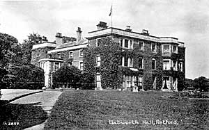
Babworth Hall.
The route to the village of Babworth is by way of West Retford and along the Worksop road. The village, as seen from the highway at the foot of the hill, presents a strikingly beautiful appearance. The Hall, standing on an eminence, the many - gabled rectory, the church embowered in trees, the expansive lawns sweeping down to an ornamental lake with islands, and a background of woods, together compose one of the fairest pictures of this part of the country. The church is prettily situated on an eminence. It contains many monuments to members of the Simpson and Eyre families and several memorial windows. In the hamlet of Ranby, two miles north, a square stone was set up in 1802, to commemorate the finding of sixty-two copper and twenty-nine silver Roman coins.
The town portion of Clarborough, consisting of North Retford, forms part of the borough of East Retford. The village of Clarborough is reached from Retford market-place by way of Moorgate, and St. Saviour's—a modern church—through the hamlet of Welham, the road being the old Retford and Gainsborough turnpike. Before reaching the village we pass through the hamlet of Welham, just beyond the borough boundary. This hamlet is named after St. John's Well, largely used a century ago for rheumatic and other complaints. It still remains entire, and though little known, is worth seeing. It is situate about two hundred yards down "Bone-mill Lane," at Well House, occupies the whole of one room, and consists of a stone basin some ten or twelve feet square, with a flight of stone steps and a ledge for bathers.
The ancient parish church of St. John's (key at parsonage, if closed) occupies a pleasant situation in the village of Clarborough. It consists of chancel, nave, and aisles, also an embattled tower decorated with four crocketed pinnacles. In the churchyard is a yew tree, said to be a thousand years old. At Bolham, a hamlet of this parish on the east bank of the river Idle, are a couple of costly bridges within two hundred yards of each other, reservoirs, the historic corporation shuttles, and some hollows in the rocks said to have been at one time inhabited. Little Gringley is another hamlet. Near to Castle-hill wood are traces of a Roman encampment, consisting of a moat and a fosse, about a mile in circumference.
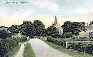
Eaton, 1906.
Eaton, which is reached by way of the Great North Road, is on the banks of the river Idle and is the traditional site of the bloody battle fought in 617, in which Redwald, King of East Anglia, defeated Ethelfrith the usurping King of Northumbria. Redwald, who was sheltering Edwin the true Northumbrian king, refused to give him up; and by reason of his victory was able to place him again upon the throne. Edwin married Ethelburga, daughter of Ethelbert, the Christian king of Kent, a princess of exemplary piety "of great beauty and noble spirit," and was himself subsequently baptized by Paulinus. It was at the Council at which Paulinus was urging upon Edwin the adoption of Christianity, that one of the nobles gave utterance to the famous apologue comparing human life to the flight of a sparrow entering a lighted hall from the darkness and passing out again to the dark unknown. Eaton church (key at Mr. Mark-ham's) is modern. The return to Retford can be varied. There is a path west of the river and across the fields to Ordsall village.
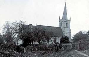
Grove Church, c. 1905.
The village of Grove lies east-south-east of East Retford. It is reached from the market-place by way of Grove Lane to Little Gringley, and through Grove Park. The village, which at the time of Domesday, belonged to Roger de Busli, owner of many manors hereabout, descended to the de Hercys, the Nevilles, the family of Levinz, the Eyres, and the Harcourt Vernons. Members of these families have influenced the destinies of England as warriors on land and sea, and as statesmen, scholars, philosophers, and leaders of the church. One of the Nevilles it was—Sir Edward—who presented the corporation of Retford with the larger of the two maces. He in the seventeenth, William Levinz in the eighteenth, and Granville Harcourt Vernon in the nineteenth century, all represented Retford in the House of Commons. Grove Hall, a beautiful mansion, on an eminence, and visible from the Great North Road, was erected originally by the de Hercys, but has at various times been altered and enlarged. It is now in the possession of the Harcourt Vernon family. The church was built in 1882 from designs by Mr. C. Hodgson Fowler, and stands north of the site of its predecessor. Most of the ancient monuments have surrendered to the common destroyer, time, but two still remain, and may be seen in the floor of the belfry chamber under the tower. One of them is, no doubt, to the memory of Hugo de Hercy and his wife. The inscription was barely decipherable a century ago, but it bore date, 1455. The identity of the other stone is doubtful.
Hayton-cum-Tiln can be visited from Clarborough, being only half a mile farther along the main road. It is a straggling village on the east bank of the Chesterfield Canal, with an interesting church representative of good Early English arcnitecture with later additions, the north wall of the nave, however, being Norman work. There are a number of memorials and several modern stained glass windows. Tiln is on the bank of the Idle, two miles distant. The return from Hayton can be made by way of Hayton Smeath to Tiln road.
(b) Villages suitable for a circular tour by cycle, motor car, or one of the many conveyances to be had in East Retford.
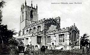
Gamston, c.1905.
The roads connecting these villages can easily be traced on the ordnance map supplied with this handbook. Following the Great North Road due south we reach Gamston, a scattered village on the river Idle. The church of St. Peter (key at the vicarage) is mainly Early English, but has a fine Perpendicular tower, 120 ft. high, with eight crocketed pinnacles. The restoration in 1856 was very largely a rebuilding and the north porch and the roofs are of this date. A round tower or turret still remaining seems to indicate the existence at one time of a rood loft. Near the south wall is the effigy of a knight supposed to be that of Sir Nicholas Monboucher, a fourteenth century lord of the manor and probably the builder of the church tower. Within the altar rails is the recumbent effigy of a priest apparently blessing the chalice.
The Baptist chapel in the village is the meetinghouse of a very old Dissenting cause. It stands on the site of an earlier one built in 1741, and previously to this date there had been a meeting-house, visited as far back as 1673, by the Rev. Dan Taylor, founder of the General Baptist Association. Baptisms took place in the river Idle till recent years. In 1782, a candlewick manufactory was erected at Gamston. Twenty bleachers were employed on eighty acres of bleaching ground: more than one hundred hands worked in relays night and day, and £400 was paid weekly in wages. In 1854 this factory was demolished.
Elksley, the next village, lies about a mile and a half from Gamston. It is one of the villages of the old Sherwood Forest and is close to the Old North Road. From it there are walks by winding streams and shady woods to the celebrated Normanton Inn and Clumber Park. The church of St. Giles (if closed apply at the vicarage, or to Mrs. B. Hancock, Junr.) contains nave, south aisle, chancel, and an embattled west tower. The south door of the church, of oak, bears the date 1612. The old font is used in the village as a pump trough. In the churchyard is a gravestone bearing the inscription:—
Here lieth the body of John Baragh, gentleman, who was murdered by Midford Hendry, officer of the Guards, on the 24th day of June, 1721, age 29 years.
This gruesome murder was perpetrated at Jockey House, a mile north on the old road, and an entry in the register states that Baragh was stabbed. For the purpose of changing barracks, a company of Guards, commanded by Hendry, was riding on the Great North Road southwards. They halted at Jockey House for refreshments. Hendry took a seat by the side of Baragh, who was, presumably, a stranger. The two entered upon a political discussion which grew violent, and at last Hendry drew his sword and stabbed Baragh to the heart.
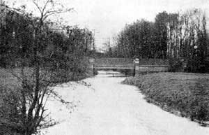
Twyford Bridge.
From Elksley we turn southward and descend a small declivity to reach Twyford Bridge. Here the Maun, the Poulter and the Meden unite to form the river Idle, and five roads converge upon the bridge. In 1503 Queen Margaret Tudor passed this spot in her bridal procession. Long before the days of stage coaches and when the road was a quagmire, Twyford was the scene of many a wild ride, many a desperate adventure. We alight for a moment, to glance over the parapet at the little stream winding peacefully frcfm out the brake, before continuing our journey.