< Previous | Contents | Next >
BUDBY
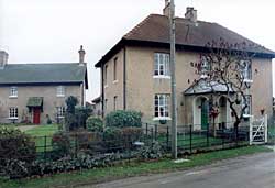
Cottages at Budby (A Nicholson, 2003).
IT has been well said by an eminent writer on country life, that "there is not a more beautiful sight in the world than that of our English cottages in those parts of the country where the violent changes of the times have not been so sensibly felt, where manufacturers have not introduced their red, staring, bald, brick houses, and what is worse, their beer-shops and demoralisation ; where, in fact, a more primitive simplicity remains. There, on the edges of the forests, in quiet hamlets, and sweet woody valleys, the little grey thatched cottages, with their gardens and old orchards, their rows of bee hives, and their porches clustered with jessamine and roses . . . there they stand, and give one a poetical idea of peace and happiness which is inexpressible; well may they be the admiration of foreigners."1
Surrounded on every hand by pleasing sights and sounds, what opportunities of happiness are within the reach of the humble dwellers here! Life passed in scenes like this ought certainly to be affected for the better, although the faculty of appreciating lovely objects is not given to all. But, that there are some dwellers here who appreciate the beauties of nature may be seen in the careful training of the old-fashioned pink rose that blooms so luxuriantly over yon parlour window. And those noble hollyhocks would not hold up their heads so proudly, or those lilies and carnations grow so fine and smell so sweet unless the hand that tends them was a loving one.
The beautifully clear river Meden flows by the side of the road, and adds greatly to the attraction of the village. The further bank of the stream is overgrown with low shrubs and reeds, where the aquatic birds that frequent the river make their nests; among others, the water hen, who here seems to have thrown aside her timidity, for though so near these dwellings she frequently crosses the road in order to feed with the poultry in the farmyard.
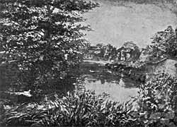
The River Meden at Budby.
From the bridge may be seen, a little lower down the river, a fine group of Scotch firs, reflected in the water, which is undisturbed save by the stately movement of the swans, whose graceful forms serve to emphasise the rude grandeur of the pines.
In the reign of Charles the Second when a perambulation (which is said to have been the last) took place of Sherwood Forest, one of the boundaries named is the' King's Stand, in Budby North Forest, where the Stuart Kings were accustomed to watch the progress of the hunt. In old times the forest, or a chase, differed from a park in not being enclosed, but in being defined by metes and bounds. These boundaries had to be inspected at intervals, and in 1662 twelve jurymen were engaged on the borders of Sherwood for upwards of a month in this occupation. From the King's Stand in a southerly direction, other limits of the forest were at Gleadthorpe, Warsop, Pleasley Mill, near Newbold Mill, Teversall Bridge, near Hardwick Hall, Linby Mill, Bulwell, Basford, Radford Mill, and the Trent Bridge, Nottingham. While from the King's Stand in a north-westerly direction the boundaries were in Nortonfield side, at Cat hill, Clown fields, Welbeck Park, Clumber yate, Thoresby fields, Conyngswath (the King's ford), near Haughton Park, the "High Street of Blith," which the writer says "is a way that leadeth from Nottingham to Blith by Horton Parke Side, and followeth the same hie street to a place called White Water, and so along the said street, leaving Boughton Fields on the east part, and Olerton Fields, and the Towne, on the west part, and soe to Blith Street Lane, which goeth up to Mellow, alias Melleigh, and there it is crossed with a way which goeth from Newark to Warsopp and there it entereth into the demesnes of Rufford at Wellye Gapp, and still proceedeth by an old lane crossing a great way leading from Kneesall to Mansfield, by Reuen Grange, leaving it on the east, and leaveing Wellye also on the east, and then neare unto Blake-stone Hall now called Southsellrs leaving the olde Parke on the east, and proceedeth along by the said Parke, to the way that goeth to Nottingham, between Shire Oaks field and the Brook that runneth into Rufford Dam, and so along the said Highway between the fields of Bilesthorpe and Winkersfield, and then to an old ditch which is the outside of the Boundaries of Rufford on the East, until it come unto a stone called the Abbot's Stone which is the Pertition between the Grounds of the Abbott of Rufford, and of the Archbishop of Yorke, and so it extendeth itself southward till it come over against Darton Grange, and always keeping the way, turning a little Westward until it come to the river of Dorbeck," and by various other boundaries, the last being the Trent bridge at Nottingham.2
< Previous | Contents | Next >
1 Hewitt's Rural
Life.
2 Stapleton, The Last Perambulation of Sherwood Forest.