< Previous | Contents | Next >
24. Towns and Villages. Their Names and Distribution.
Our Teutonic ancestors were not merely warriors. They fought, not for the sake of fighting, but to secure for their families homes to live in and lands to cultivate. From them the great majority of our towns and villages received their names. Such endings as ton, worth, ham, borough, stoke, statue take the imagination back fifteen hundred years, and conjure up the picture of an Anglian group of settlers marking off a piece of ground for its own and protecting it from sudden attack by planting a hedge or erecting a stockade.
To this enclosure the name of the chief man of the settlement was often given, e.g. Beckingham and Ruddington, from the personal names Becca and Rudda respectively. The endings ley and field raise pictures of peaceful occupations. The former signifies a pasture or forest glade, the latter a clearing made by felling trees. Sometimes a name contains a record of former features of the countryside. Thus ey in Mattersey depicts this place as an island in the midst of a sea of swamps, but holme was the Scandinavian for an island enclosed by a river. Round Sutton-in-Ashfield ash trees abounded. At Farnsfield ferns were numerous. Beavers built their little mud huts at Bevercotes. Halam means “at the meadows”; Harwell, “hare spring”; Shelford, “sloping ford”; Worksop, “Weorc’s valley.”
As communities grew and extended “North,” “South,” “East,” and “West” were prefixed to some place-names. In some cases these became altered almost beyond recognition, as in Sutton and Norton. The sites for enclosure were chosen for the sake of certain natural, advantages they offered—a good supply of water, proximity to fertile soil, freedom from floods, etc. It is not difficult to discover the causes which produced these advantages and therefore governed the choice of sites.
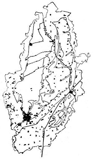
Map showing distribution of Notts towns and villages.
In the accompanying map the shape, size, and position of every town and village in Nottinghamshire is shown. A glance at it reveals at once their scarcity in the Bunter country. Here the soil was not sufficiently fertile nor the water accessible enough to offer any great attractions to settlers. The few villages that are found are situated either on the rivers or on the extreme eastern margin of the Bunter, where water is sometimes ten feet below the surface. Thus it came about that in this area much primeval forest and waste were left unenclosed and became a royal hunting ground. On the other hand its sylvan beauty and quietude attracted the monks, who established many of their monasteries either within or close to its precincts. In later times extensive portions passed from the hands of king and clergy and became those great landed estates now known collectively as the Dukeries.
The outcrop of the Waterstones presents a marked contrast to that of the Bunter. Consisting as it does of layers of sandstone and clay, it yields a fertile loamy soil and an abundant supply of water which can be obtained from springs or by means of shallow wells. These two advantages attracted the early settlers and account for the many villages between Retford (R), Southwell (S), and Nottingham (No). Occasionally a village, like Lambley, stands mainly on the Keuper clay but gets its water from wells sunk through this into the Waterstones.
The outcrop of the Keuper bears many streams, but portions of these are liable to failure during spells of dry weather. The sandstones of the Skerry bands yield a better and more constant water supply, and also produce a lighter soil than does the clay. The presence of an extensive area of this stone has furnished sites for a group of large villages north and south of Tuxford. In the Vale of Belvoir many of the villages are situated on that margin of the Keuper which lies next to the alluvium and stands sufficiently above this to lift the villages beyond the reach of the floods of the Smite. The string of villages from Langar (L) to Cotham (C) stands upon the outcrop of the Lias limestone. This is more resistant than the Keuper and Lias clays, and consequently has formed a range of very low-lying hills. Here, then, the villages have a suitable foundation, a supply of comparatively good water drawn from the limestone, and a situation elevated above the flood levels of the river.
Within the vale of the Trent also the sites of the villages have been largely determined by the necessity for escaping from the floods. With few exceptions they all stand upon those patches of gravel which, as shown in an earlier chapter, rise ten or twenty feet above the surface of the alluvium. This elevation is sufficient to save the villages from all but the severest floods. At the same time the gravel provides a dry foundation and does away with the necessity for wasting the fertile alluvium in building sites.
Up to 1850 the southern building line of Nottingham coincided with the boundary between the Bunter and the alluvium. At that time the latter was used as a pasture by the citizens. Even now that it has become valuable for building purposes it is still called “The Meadows.”
In the Coal-measure and Permian areas the villages are numerous, but have lost their original compact character. Buildings have crept out along the roads, whilst the intervening fields have been retained for allotments and agriculture. Thus typical straggling colliery villages have grown.
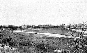
Scrooby from the North. Great North Road on the right.
In the early days each village was self-contained and its inhabitants had little to do with those of the neighbouring villages. Whilst therefore the Fosseway provided a good means for penetrating the country, settlements were made several miles from it and at the centre of the area to be cultivated. The road was, and still is, used as the boundary between townships and parishes. A thousand years later all the villages were knit together by a sense of common nationality and by many common interests. The main highway at this time was called the Great North Road because it passed through so many towns and villages. The North Road, though more ancient, fell, as we have seen, into comparative disuse for the contrary reason.