
< Previous | Contents | Next >
25. The Making of Nottingham.
After considering the geography of the county it will not be out of place to summarise the influences which have controlled the origin and growth of that city which gave the county its name and now contains nearly as great a population as all the other towns and villages combined.
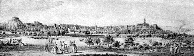
Nottingham in the middle of the Eighteenth century.
In the last chapter it was seen that sites must have been chosen because they possessed certain natural advantages. This is equally true of Nottingham. The accompanying picture shows the city as it appeared about the middle of the eighteenth century. Then and in previous centuries it was situated wholly within a half-saucer-shaped hollow, with the castle rock like a bastion at one end and St Mary’s hill at the other. Between was a semicircle of high ground which sheltered the hollow from the cold north and north-easterly winds and gave it a southerly aspect. Here, then, was a warm and sheltered site with places on either side which could be easily fortified and used as refuges.
On the south and west ran the Trent and Leen with their unfailing water-supply and abundance of fish. Away to the north and east stretched the forest, whence could be obtained wood for fuel and game for food. The underlying sandstone was soft enough to be easily excavated into caves and dry enough for these to be habitable. Though the soil was indifferent the situation was unique, for within a radius of three miles was to be found, with one exception, every type of rock and consequently of soil within the county.
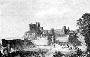
Nottingham Castle in the Sixteenth Century.
Whilst the city offered these advantages to the inhabitants it occupied a position of strategic importance at a time when the country was divided into little kingdoms struggling one with another for supremacy. At that time the Trent was a formidable barrier to the movements of armies. If an army came from the north it naturally avoided the hill-country of the Pennines on the west and the swamps on the east. Beyond the river its path was barred by the precipitous nature of the opposite side of the vale and by the Belvoir Escarpment. Only one of two courses remained,—to cross the Trent at Newark and go up the valley of the Witham, or to cross it at Nottingham and use the valleys of the Soar or Upper Trent. As the powerful kingdoms of Mercia and Wessex lay to the west and south the latter course would be the more usual.
It is not surprising that to these natural advantages artificial ones were soon added. By the ninth century a great road to the north had come into existence. This kept strictly to the dry sandstone country and was thus more passable at all seasons than if it had been made upon the clay. It struck this country at its most southerly limit, namely at Nottingham. By the eleventh century the importance of the situation was still further enhanced by the addition of a bridge and a Norman fortress. For a long time Nottingham’s central position in the kingdom, its magnificent castle, and the abundance of sport in the neighbouring royal forest caused it to be the frequent resort of the kings. They were usually accompanied by a large retinue. Many people would also congregate here in consequence. Such a place was a suitable one for holding markets and fairs, and provided opportunities to exchange merchandise at a time when shops were nonexistent. It thus became a trading centre.
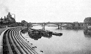
Trent Bridge, Nottingham.
Its position near to a navigable river gave it more than local importance. Throughout mediaeval and early modern times carriage overland was difficult and expensive, especially for bulky goods. During this period Nottingham served largely as a river port for the Midlands. Such things as wool, pottery, lead, coal, and gypsum were carried down, and machinery, etc., brought up the river. The making of canals and the canalising of smaller rivers at the end of the eighteenth century only enhanced its importance by furnishing more efficient feeders to its waterway.
Meanwhile industries grew up and flourished. In the development of these the neighbouring forest played its part, for it supplied oak-bark to the tanners, excellent close-grained wood to the carpenters and cabinet-makers, and fuel to the smelters of the iron ore from the Erewash valley. These last did not have their forges in Nottingham, but they supplied its smiths and armourers with iron. “The little smith of Nottingham” was far famed. It is probable that he derived his skill in metal work from the Danes.
That William Lee, the inventor of the stocking frame, lived only a few miles away was an important circumstance. Under his care a band of trained workers came into existence. Though he went to seek his fortunes elsewhere, these remained and nurtured the young industry in this district. Gradually it spread from village to village and also to Nottingham. Here many of the workers were not content merely to make stockings but, with the advantages of inherited mechanical skill, they strove to improve the machine and adapt it to other classes of work, more especially to the making of lace. Thus improvements too numerous to mention were added from time to time, often by humble and obscure workmen. Their efforts laid the foundations of an industry which has made Nottingham the lace metropolis of the world.
When hand power was replaced by water power these and other minor industries might soon have left the city, for the Leen was too small to drive many mills. However, the reign of water power was short. Steam power was introduced. This depended entirely on a good coal supply, and Nottingham had a coal field at its door and coal in its foundations. With steam power came the large factory and the consequent rapid concentration of the population in manufacturing centres.
The importance of the place and the easy natural gradients which lead to it from all directions soon attracted the railways. The network of main and branch lines which now serve it will never be easily shifted and consequently adds greatly to its commercial stability.
The gradual eastward extension of the collieries and attendant industries is enveloping the city on the north with a densely populated district. This is adding to the city’s prosperity, for even now people come from the Erewash valley and from beyond Mansfield to make their purchases and seek their pleasure in Nottingham.