Scrooby
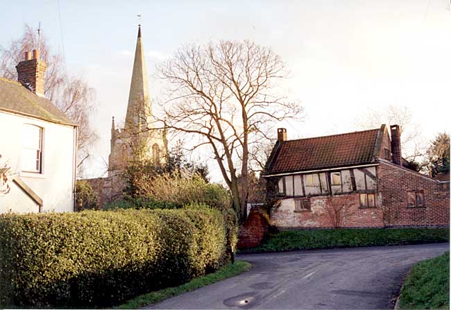
Scrooby church and Brewster's Cottage (photo: A Nicholson, 1998).
The parish of Scrooby is at the extreme north of the County of Nottingham, from the City of which it is about thirty-four miles distant, and eight miles from Retford, its market town. The population was in 1801, 225, which in 1841 rose up to 297, but diminished to 243 in 1911. The area is 1608 acres, 17 of which are water. The only industry up to the present has been connected with agriculture. The rateable value is £5,423.
The name Scrooby indicates its Scandinavian origin, the first part having reference to a personal name, possibly Skorri, (Mutschmann), and the second to his farm or hamlet. The variations in spelling were: Scrobi, Scroby, Scrobia, Scrowby, etc.
Geology. It is desirable the young people of the district should think about the soil and rocks under their feet, and it will be difficult for them to realize that "once upon a time," as the children say when beginning a fairy tale, and we have more than a fairy tale here, once upon a time the then surface of the land is below where Scrooby stands, nearly a thousand yards from the present surface. The vegetation then grew rank and wild in rich profusion, for the climate was very different to what it now is, and so continued for a long period, until the whole growth was covered over. Possibly the children may ask whence the material in its successive layers and ages came, and how, and how long it would take to accomplish the work. Who can reply? The marvel is that now we shall be supplied for our fires, gas, and electricity with the sunshine of vast ages ago, hid by God Almighty until our day and for our use.
By the kindness of Mr. C. W. Phillips, the Engineer of the Harworth Main Colliery, which is in the parish adjoining Scrooby, I am supplied with information as to what the borings shew. "The stratum immediately beneath the soil at Harworth is known as the pebble bed, and consists of soft sandstone with pebbles. It belongs to the Bunter formation of the triassic period, and forms the base of the secondary group or cycle of rocks. The descending order will, therefore, be as follows:
"Bunter" consisting of red and yellow sandstone, pebbles, red marl and gypsum, frequently containing huge quantities of water, to a depth of 130 feet. The boring was carried a further depth of 113 feet into the Magnesian Limestone, consisting of grey and brown limestone, usually with fissures and containing water. Huge quantities of water will have to be dealt with from a depth of 70 feet until the base of the Magnesian Limestone is reached. The Magnesian Limestone in the Doncaster Coal field can be likenened to an underground reservoir, for it is honey-combed with saturated fissures, possibly arising from the fact that limestone is partly soluble in water. This difficultv has to be overcome by the cementation process of sinking. A cement mixture which will set under water is mixed at the pit top, and pumped into the water bearing strata surrounding the shaft. The setting of the cement is indicated by a stoppage of the flow of water into the shaft. The shaft is then pumped dry, and sinking proceeds as through hard ground.
Below the Magnesian Limestone is the Permian Sandstones, and below that the Coal Measures, consisting of Shale, Bind, Clunch, Sandstone Rock, Bat, Bands of Ironstone and seams of coal."
The coal intended to be worked is the Barnsley seam. "Proof of its existence is based upon the fact that it is being worked at Maltby, and Rossington to the west, and that it was proved in the South Car bore hole to the east. The depth of the seam at Maltby, Rossington, and South Car is 820 yards, 872 yards, and 1048 yards respectively, and it should be found at Harworth at a depth of 900 to 950 yards. The increased depth is due to a general thickening of the superincumbent strata towards the east.
The ultimate capacity of the mine will be 5,000 tons per day, but this output will not be attained until about eight years after the coal is reached."
Environs. The parishes surrounding Scrooby are (1) Scraftworth, which is joined to Everton, with its church of the twelfth century, having some fine Norman work. (2) Mattersey, where was a Gilbertine Monastery, a small portion of the ruins of which remain. (3) Ranskill, a thriving village with an old Manor Court, and a new church. It is in the parish of Blyth (4) at which place a Benedictine Priory stood, with its twin monastic and parish church and monuments of great interest; its charming park and village greens, with flower-adorned cottages. Barnby Moor and Hodsock Priory are in this parish, the latter having historical associations, although not a priory. (5) Serlby Hall and Park with its famous beeches and charming view, and instructive family history. (6) Styrrup, where the great tournaments were held seven hundred years ago, now a part of the parish of Harworth, (7) at which a great colliery is being opened out. (8) Bawtry, which formerly had a market, and was with Austerfield, part of the parish of Blyth. (9) Austerfield we shall be obliged in our story mentally to visit. Bawtry is between it and Scrooby. It has a quaint parish church, dedicated to St. Helen, built in the latter half of the twelfth century, having a Norman doorway with a compound arch, zigzag and beak ornaments, and a dragon carved.
It is singular that in the parishes surrounding Scrooby the mansions and estates of Viscount Galway, C.B., A.D.C., the Chairman of the Notts. County Council and Colonel Mellish, C.B., the Vice-Chairman, and Chairman of the Notts. Education Committee, should both be located. The north leads and rules the south, and rules well.
The Rivers. Scrooby is well watered, "like the garden of the Lord," for the five streams of the Rainworth-water, the Maun, the Meden, the Wollen, and the Poulter, become the Idle, and form the eastern boundary of the parish. The Ryton, rising near Shireoaks, runs on the west of Scrooby but at Gibbet Hill makes a sudden bend, and running by Scrooby village it grinds the corn at the old mill, and enters the Idle, which flows by Bawtry to the Trent, the latter stretch having been formed into a navigation. From Retford to Bawtry, the river was once navigable for small boats, but it preferred to revert to the character of its name. The Idle and its contributary streams above named were evidently favourites in the olden time, for by their banks the Abbeys of Rufford, Roche and Welbeck, and the Priories of Worksop, Wallingwells, Blyth, and Mattersey were formed.
Roads. The Great North Road from London to York and Edinburgh which runs through Scrooby, one would expect to have been made early and kept in good condition, but it was not, and for a considerable length it was an unenclosed tract through open country. In 1555 Parliament passed an Act requiring every parish to elect two Surveyors to keep the highways in repair by forced labour, but it had little effect. Even in 1700 it is said that it took from four days to a week to go from London to York. An Act was passed in 1766 which recited that some of the local roads being narrow and ruinous, could not be sufficiently repaired, widened, and kept in repair by the ordinary course of law, a diversion was therefore made from Markham Moor to Barnby Moor, bringing Eetford on to the main line, and when £1,000 raised by private subscription had been spent, Mr. John Bright deposed before the House of Commons Committee that the roads were still bad and ruinous. The poor old road, being deserted, speedily covered itself with grass. Another diversion was made in Scrooby by the Turnpike Road Trustees who had authority to construct and divert so as to overcome the disability owing to the narrowness of the road in the village.
The North Road from Nottingham via Blyth, described in Domesday Book as "the road to York," joins the Great North Eoad a little north of Scrooby; as also does the old Boman Eoad from Lincoln to York, crossing the Trent at Littleborough.
Ogilby's "Road Book,"(1675) page 13 says: "At 143.5 (miles from London) you pass through Ravenskel, a small village by Sorlby on the left, come at 145.3 to Scrooby a village of two furlongs, from which an open way brings you to a Rill at 146.6 where together you enter Yorkshire and Bawtry." It shows the road as then going through the village.
Bridges. The bridge over the Idle, called Bawtry bridge, was in 1547 in great ruin and decay, and no less noisome to the travellers, so they pulled down the chapel of our Lady at Scraftworth and mended the highway. It was repaired in 1609 at the cost of the hundreds of Bassetlaw and Newark. It was rebuilt of wood in 1738 at the joint expense of Notts. and Yorkshire. In 1810 it was rebuilt on 144 piles, 15 feet in length, covered with planks, on which rested Roche Abbey stone, and cost £3,000. (Peck). The bridge over the Ryton on the Great North Boad was erected in 1767, which was eight years before the Inclosure Act was passed. The road was then a Turnpike Eoad, and probably the bridge was built by the Turnpike Trustees, but it is now a County Bridge.
Hatfield. If three hundred years ago we had stood on Bawtry Bridge, or its site, as a pivot, and faced the south or south-west, we should have looked on the district of the Hatfield, or Sand, Division of Bassetlaw Hundred, stretching from Scrooby to Clipstone, near where the mighty oaks and beautous silver birches of Sherwood Forest grew, "with an infinite number of deer and stags with lofty antlers," and a great wood stretched thence to Nottingham. Now turning on the pivot and looking north-east, we should have faced Hatfield Chase, the central part of which had 70,000 acres, but the whole run of the Chase, including the purlieus, extended to 180,000. At the beginning of the reign of James I. there were a thousand red deer in Hatfield. The district was in 1626 drained under the direction of Sir Cornelius Vermuyden, at a cost of, some said £400,000, which may be was excessive. Probably some benefit accrued to Scrooby by this drainage scheme. Now we can see why Henry VIII., Queen Elizabeth, and James I. in succession, desired to have Scrooby Manor House. It was the centre of a vast sporting country.
Danes. There was in 617 a battle on the river Idle between the Northumbrians and East Anglians, where the King of the former was slain, and this may have affected the district. But the name of Scrooby carries us forward to the coming of the Danes (866) who extensively located themselves in the district, as the names of Barnby, Ranby, Serlby, Saunby, etc., tell. Ranskill is Danish. So are the many "thorpes." We may hope that when they entered they quietly superseded the older inhabitants, but in some places, in this and the following century, their coming was accompanied by fire, destruction and slaughter, before they settled down and supplied us with kings. The probability is, however, that the district was then of the nature of forest, and had to be cleared.
Normans. When Domesday Book was compiled (1086) twenty years after the Conquest, the parish was a berewick, or dependency, and part of the Manor of Sutton-cum-Lound, which is five miles to the south, the land being the property of the Archbishop of York. "In Sudtone (Sutton) and Scrobi (B) (Scrooby) and Lund (B) (Lound) (there is) one caru-eate of land and six bovates (assessed) to the geld," for the king for national defence. (? 120 acres and 90 acres). The quantity and state of the land in the three places is all joined. "Archbishop Thomas has there 2 ploughs (or plough teams, or plough lands) in demesne (or home farm) and 14 villeins (subject tenants) and 6 bordars (serfs and small tenants) having 6 ploughs." Meadow and Woodland are also mentioned.
Plumtree. To the north-west of the parish is Plumtree Farm. In 1178 John the Constable of Chester granted the town of Plumtree to the Archbishop of York. In 29 Henry VIII. the Archbishop demised his great close paled about (called Plumtree field, besides Scrooby Park) with the lodge and all his warren and game of conyes for the rent of £12. 12. 0. to Geofrey Lee his brother.