Civil War. We do not know how the civil war (1642) affected the men of Sneinton. The Earl of Kingston, who was the landlord, tried to keep out of the fray, "till at length," Mrs Hutchinson says, "his fate drew him to declare himself absolutely on the King's side." His eldest son, Lord Newark, who was Lord Lieutenant of the County, was on the King's side, but the Earl's second son, Mr. Wm. Pierrepont, was for the Parliament, and a third son, Mr. Francis Pierrepont, who lived in Nottingham, Mrs. Hutchinson says, "coldly owned the Parliament." The majority of the men of Nottingham going for the Parliament would put the little village of Sneinton in a state of uncertainty and turmoil.
A considerable portion of the land in Sneinton did not belong to the Pierrepont family, and in 1648 (two years after the King's surrender at Southwell, and a few months before his execution) John Musters, Esq., bought from Sir James Stoneham the manors and lordships of Over Colwick, and Colwick Novers, also Nether Colwick, and about 300 acres of land in Sneinton, for the sum of £18,000. When the Inclosure Act came the two Houses seem to have had about equal ownership.
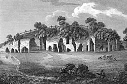 |
| The Hermitage, Sneinton, in the early 19th century. |
The Hermitage. It is possible that once upon a time the Hermitage was a cell of some recluse, or religious order, similar to the caves in Nottingham Park, which were at one time connected with Lenton Priory, but more probably it was the secluded dwelling in the rock of someone who loved to be alone. In the Pierrepont rental of 1544 is an entry, "Item. There is a hous under the grounde in a rocke of stone that sometyme was called thermitage''; and again in 1501, "The Ermytage in Sneynton, being a howse cutte out of rocke and paieth yearly ijs. (2s.) It is very improbable that we are here to be carried back to the time of the British inhabitants, before the Saxons dislodged them, when Nottingham was called Tigguocobauc, "the dwelling of caves."
When the road was made from Southwell Road, by the Hermitage, until it joined the road to Colwick at Old Sneinton, two public houses, the "White Swan'' and the "Earl Manvers' Arms," with other adjoining houses were built, having brick fronts, the caves forming the back premises, and on the rock above the Nottingham Catchfly grew plentifully. In 1829 a lofty rock overhanging fell and crushed two houses, and destroyed "the noble dancing room cut in the rock." The North Western Railway Company having established their goods station on the top of the rock, the Great Northern, in 1897. for their high level line pushed the road sixty feet or so further north, the road was widened, and most of the houses and caves to the west were removed. In 1904 the houses and caves east of the railway bridge were blasted, or pulled down, one cave being 36 feet by 86 feet by 18 feet high.
Mr. J. T. Radford has an interesting series of photographs of the caves as they were, and Mr. A. Stapleton has a small booklet on "Nottingham Caves and Notts. Coal.''
The Hook. The Hook is that part of the parish which by the shifting of the course of the Trent has now become on the southerly side of the river. The old course may be seen in Boots' Recreation Ground, and again by the northern side of Adbolton Boad, at West Bridgford. The Hook appears to have been, in 1689, let to the "Inhabitants of West Bridgford," when it was rated at £24.
Glasshouse What is now called Southwell Road was called Old Glasshouse Street, and Mr. Granger gives an extract from a book of about 1772, showing that Widow Pilkington paid for "an encroachment by a house on the waste near the Glass-house in Carter Gate, 2s. Deering (1751) gives an engraving showing the glass-house with a vigorous smoke.
Was this the same as the King's high road to Sneinton mentioned in 1328? B.R. 387. Here was "Snaynton forthe," 1486—the ford over the Beck.
"Ye cawsay (causeway) from ye two smal brygges (bridges) to ye forthe (ford) yat gos into Snenton medow." B.E. 360. 1577. "We do present the wey (highway) betwex the Tylle Housse and the stone bredge towardes Snenton to be vere nedefull to be mended." Page 172.
Pennyfoot Stile. In Sandby's engraving of the " East Prospect of Nottingham," 1750, as taken from Sneinton Hill, the houses about Carter Gate appear to have been the then eastern boundary of the town, and from that line to Sneinton is shown as fields and gardens, with a row of trees growing vigorously by the beck or brook. From the brook to Fisher Gate appears a raised causeway or platform, on substantial piers, apparently six or eight feet high, with a boarded fence on one side, and a footbridge over the big dyke with a stile on the town side of the stream marked as "Penny-foot Stile." What is now called the "Bottoms," and Manvers Street are shown as pleasant fields. This footpath was then used as the way from Sneinton to St. Mary's Church and the Market, while another footpath from Colwick by the Hermitage joined it.
Bartholomew Stile. "Bartelot Stye aght (ought) to be xl fute brod be ye zerd (yard) and of yat longes to ye Pynder fee of Not. feldes ye halfe. And ye other halfe to ye Pynder of Snenton." 1435, B.R.. p. 361.
The Manor House. The Manor House was a large old-fashioned, three-storeyed, ivy-mantled, many gabled red brick house, standing in its own grounds, with large courtyard, on the hill overlooking the Hermitage Rock, having a magnificent view over the Trent Valley to the Leicestershire and Derbyshire hills. The name "Manor Street" is the only reminder.
The author of "The Beauties of England," 1812, says, "The village itself is rural, at present in some measure romantic; has a number of pleasant villas and cottages, and has long been famous for a race of dairy people, who make a very pleasant kind of soft summer cheese."
New Sneinton. New Sneinton was the part of the parish between the Church and Nottingham, the first house being built in 1804. In March, 1824, two closes east and west of the Beck, occupied as gardens, were sold by auction by Lord Manvers' Trustee, at the Blackmoors' Head Inn, High Street, subject to conditions of sale which, according to papers in the possession of Mr. W. F. Grundy, required that the houses built in Sneinton must be not less than three storeys high above the surface of the ground, must have front bricks and sash windows, and the streets were set out as 24, 27 or 30 feet in width. The care exercised in these restrictions was not accompanied by any forbidding cellar kitchens, or back to back houses, or narrow entries, or insanitary arrangements. The gardens, says Wylie, "were but a mere swamp," yet the lots were knocked down at from 11s. 6d. to 24s. 9d. per square yard. Those streets we to-day call Manvers, Pierrepont, Newington, with other adjacent streets, and they are part of the condemned area.
According to Staveley & Wood's plan, 1831, there were then no houses between the Beck and Sneinton Road, south of Pierrepont Street, and between Haywood and Byron Streets from Sneinton Road to the Asylum was all gardens, as was also where Walker Street now is. Long Hedge Lane (now Gordon Road) was surrounded by fields, and from the old Pottery (now Cowen's Foundry) eastward, there was not a house. Three wind-mills stood on the hill. In Dearden's plan, 1844, the eastern side of Sneinton Road appears built on, Walker Street has started building, and the Lowdham Street estate appears as laid out and partly built on. About that time Sneinton was a kind of rendezvous for Ministers and Scotchmen.
Sneinton Elements. This peculiar name for a cluster of streets con sisting of small houses, some built 100 years ago, on the Carlton Road, formerly called Element Hill, was probably given because of the exposed situation on the northern hill.
Roads. A plan of the road from Nottingham to Grimsby, by John Ogilby, Esqr., His Majesty's Cosmographer, supposed to be of the date of 1675, shows the road to Newark and Lincoln to be, not by Trent Bridge and Radcliffe, but by Sneinton, up a hill marked with a Beacon, then down to Charlton (Carlton), Burton, Gunthorpe, and crossing the Trent at "Bleasbey Ferry."
The Midland Railway first ran through the parish in 1846; the Ambergate (afterwards the Great Northern) in 1850; the North Western in 1888, and the Suburban in 1889.
Thorneywood Chase. Thorneywood Chase was a branch or part of Sherwood Forest which belonged to the King. Queen Elizabeth in the forty-second year of her reign made a grant to Sir John Stanhope, Knight, and his heirs for ever as Ranger or Keeper of Chase. The wood was well stocked with fallow deer. Eighty acres of the Chase was in the northern part of the parish of Sneinton, and was called Sneinton Common. This land was in 1792 valued for the Commissioners of Woods and Forests at 12s. per acre per annum, and if enclosed it would be worth 25s. per acre. The rights of the Crown had so long been neglected that only forestal rights were left, and were valued at one-fortieth part. The Earl of Chesterfield claimed one-twentieth part in right of his Chase, but one-tenth he doubtless thought better.
Shepherd's Race. The Shepherd's Race stood on Sneinton Common, formerly Sneinton Wood, by the side of where a street called Thorneywood Mount now is. It was a maze or labyrinth, cut out of a flat turf, in an exceedingly intricate manner, requiring great agility and dexterity to keep erect and to find the way out, and it was resorted to for exercise and amusement. The length of the winding was 535 yards, but the measure of the land was only 324 square yards. There were curious projections at each corner. Blackner waxes hot with indignation that a spot of earth so long devoted to rustic sport should have been, through the Inclosure, ploughed up on the 27th February, 1797. It was included in the land allotted to John Musters, Esqr.
Query:—Was it called the Shepherd's Race because shepherds who were guarding their sheep on the common wiled away their time by running on the maze, and so became agile by long practice, as David became skilled with his sling by constant throwing?
The Inclosure. The Act for dividing, allotting and inclosing the Open Fields, Meadows, Pastures, Commons and Waste Lands within the Parish of Snenton was passed in 36, George III., and the award in 1798 allotted:—
|
A. | R. | P. |
| Lord Newark, as Lord of the Manor | 1 | 3 | 9 |
| The Perpetual Curate of Snenton, for small Tithes | 15 | 1 | 0 |
| Viscount Newark, for Tithes | 117 | 0 | 25 |
| John Musters, Esquire, for Tithes | 9 | 8 | 30 |
| Earl of Chesterfield, in right of his Chase | 8 | 0 | 0 |
| Lord Newark, as proprietor of Lands | 829 | 1 | 18 |
| John Musters, Esq. ditto | 275 | 2 | 37 |
| Rooke Fleming | 1 | 2 | 13 |
| Daft Smith | 8 | 0 | 0 |
| Finder of Snenton (Top of the Dale) | 3 | 0 | 35 |
| Parish Clerk of Snenton (Meadow Lane) | 0 | 2 | 0 |
| Vicar of St. Mary's, Nottingham (Carlton Road) | 2 | 1 | 0 |
Trent Lane was set out as a road for getting and leading gravel for the repair of the roads; "for the river Trent afforded the best and sufficient gravel, and the lands in the parish of Snenten did not contain any beds of proper stone or gravel.'' Plenty of gravel can now be found, but it is under the alluvial deposit. Some acres ought to have been allotted to buy gravel with the rent money. Nothing was allotted for recreation, and it recently cost the Corporation a very large sum to buy land for a park.
Tithes. All the tithes of corn in Nottingham and Sneynton yearly accruing, which had belonged to the priory of Lenton, and were then valued at £20 per annum, were in 1599 granted by Queen Elizabeth to Henry Pierponte.
In 1734 a cottage in Sneinton and croft was sold for £390, and "moiety of the tithe of hay arising within the meadows of Snenton, which was formerly appertaining to the dissolved monastery of Lenton."
A very wrong thing was done 850 years ago by the sale or grant of the big tithes on corn, hay, etc., to outsiders, and for 127 acres of land, increasing in value, to have been allotted to compensate for their extinction seems to be excessive. All tithes then ceased.
Nottingham Inclosure. The Inclosure of the common lands in Nottingham had a serious effect on the value of building land in Sneinton. Edward Hind in his book "My Magazine," 1860, says, "We can remember a few years ago when building land at Sneinton was selling for £1 sterling per yard, and we have been told of some being lately disposed of in the fields, for building purposes, at 1s. per yard." The illustration may be of extreme cases, but the effect was considerable, for before the Inclosure Act operated the land on the south, east, and north of the town could not be built on, but upon hundreds of acres being placed on the market, land in Sneinton was, for the time, being thrown into the shade, and building land is always subject to great fluctuations in value.
Sneinton Fields. Mr. Stretton, in his Manuscripts, gives a pen and ink sketch of the Malt Cross in the Market Place (erected 1686), of the Weekday Cross (1745), and a reference to the Butter Cross, and adds, "These three crosses are now lying all together in Sneinton Field where the new Village Building, 1806." The Malt Cross was in 1804 sold by auction for forty-three guineas. Six of the columns were bought for a summer house in a garden on the hill north of Minerva Terrace, and the rest dispersed. See "The Crosses of Notts.," by A. Stapleton.