
Wilford: then and now
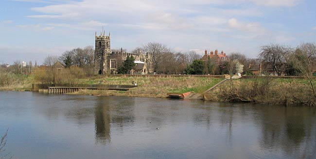
View of Wilford Church from the opposite bank of the River Trent (photo: A Nicholson, 2005).
Between Nottingham on the north and Wilford Hill on the south there is a remarkable valley, called "The wide vale of the Trent," for from the top of the hills on the one side to those on the other is several miles, yet once upon a time, as the children say, it is probable that there was no valley, or a very small one, and either the hills have been raised, or the vast bulk of material has been washed away, and not only has the valley been scooped out, but it is not unlikely that even the hill tops have been very much reduced, and the valley has been eroded much deeper than now appears, for the Bunter Sandstone rock is ten to twenty feet, or more, below the present surface. Where did the mighty rush of waters come from to accomplish such a task? And how long were they in doing it? As we walk from Nottingham to Wilford we pass under the shadow of that great rock on which the Castle stands, and we try to conceive the rush and roar of floods dashing against that great mass, and sweeping away all its southern support. If we ask for a time to be stated, must we go back to the days when England was connected with Scandinavia and the Continent? and has the land been raised, or lowered, or denuded by ice and water, so that we cannot now trace the course and action of the river that was here before the Trent was formed?
There is another wonder, for that river bed for fifty miles is now filled with gravel, sand, peat, and other alluvial deposits, to a depth of from three to twenty, or more, feet, and that gravel consists of myriads of smooth, rounded water stones, comprising quartz, quartzite, granite, jasper, flint, limestones, etc., stones of various colours, which have been for vast ages washed, worn, wasted, or smoothed, and are said to diminish in size below Newark. We must remember that all these stones, or pebbles, are fragments of rock broken off from larger ones. Where are the rocks from which the bits we call gravel were broken off? At Wilford men are dredging for gravel, and for generations it has been obtained here. Much was used for making the Colliery banks, and more for the Victoria Embankment, and still after every flood there seems to be as much left as ever. In the valley deposits above Nottingham have been found the bones of extinct animals, mammoth, rhinoceros, and hippopotamus. And the gravel is not confined to the valley, but is under the clay on the hill to the south of Wilford, nay more, the sandy, clayey, pebbles and gravel was over eleven feet deep on the top of Wilford hill, where the Reservoir now is. The school children will probably go and collect specimens, and the teachers will possibly explain what they are, and whence and how they came. (See Geological Memoirs, page 71.)
We call the Trent a noble river, but it must be very feeble compared with its vigour in its youthful days, and that of its predecessor.
Persons who desire to study the questions referred to may consult articles by Mr. Bernard Smith, M.A., a geological expert, in the "Transactions of the Thoroton Society," 1910, or on "The Ancient and Modern Trent," in "Memorials of Old Notts."
One extract may be given from Mr. Bernard Smith, referring to the gravel at the close of the glacial period, "In those days heavy floods occurred when the ice and snow melted. An immense volume of water also came over from the Cheshire plain, so that the river and its tributaries were much larger and more powerful than the present stream, which is unable to lift and spread gravel over its flood plain. The stream course was choked with debris, and compelled to split up into ever-changing branches, which spread gravels far and wide. Since their accumulation the uneven surface has been partly smoothed by deposits of fine sediment brought down to the valley by side streams."
Boundaries. Before 1877 Wilford was in the County of Nottingham, but in that year an act of parliament was passed whereby all that portion of the parish which was north of the Trent, called North Wilford, was annexed to the Borough, leaving the old parish south of the Trent, to be called Wilford, or South Wilford, still in the county.
The boundary lines of South Wilford may be roughly indicated as follows:—Starting from the southern bank of the Trent, about eighty yards west of the Suspension bridge, a passage leads to Wilford Lane which divides the parish from Bridgford. Proceeding southward, to the west of the houses on Loughborough Road, which are in Bridgford, and near to the farm-house called Springfield, crossing the road, and going right through the buildings of Willow Farm up to, and west of, Shapehill Wood (Edwalton Fox Cover), turning west at Edwalton Lane, along Landmere Lane, and near to the old brickyard on Clifton Road, over Fairham brook, and down to the Trent, one field east of Clifton Grove, and then back on the northern Trent bank.
Geology. The boys ought to know something of the dirt under their feet, for it has not always been where it is, and a study of how it came there will be full of interest. Fortunately, the sinking of the Clifton Pit in 1868, enables us to know something of what is below our feet. The depth of the pit, Major Walker states, is 265 yards, and the seam that is being worked is called the "Deep Hard." Below that are what are called the Coal Measures, in which it has been proved there are seams called the Furnace, and the Piper seams, each about three feet thick, both of which are worked in the Erewash Valley. Fifteen yards above there is the Deep Soft Seam. The Top Hard Seam, which is seventy yards from the surface, and is six feet thick, being in the water measures, is deemed to be unworkable. There are fifteen seams of coal, mostly regarded as commercially unworkable. The Bunter Sandstone rests on the Coal measures, and is fifty-three yards in thickness. Above this is seven yards of gravel, sand, silt, peat, &c, which has been washed down, and in which bog timber has been found. On the southern side of the parish the Keuper Marls have been deposited, and largely washed away, but not very far from the entrance to Clifton Grove they were found to be ninety-eight yards in thickness, consisting of marl and sandrock. About fifty yards south of the pit shaft is a fault, or wedge, where the ground has bodily sunk ninety-five yards. The dip of the coal bed is one in thirty, eastwardly. There are few fossils.
What does all this mean? It tells that every place where there is a seam of coal was once upon a time the surface of the earth, in which rank vegetation for a very long period grew, and at length it was covered up by convulsions of nature, or mighty forces depositing mineral matter over the vegetable, until the time came for the vegetation again to triumph, and this alternating course was followed twenty or more times, and after all this came the sand formation, to hold water for us, and then came mighty forces that possibly washed away the wide valley of the Trent.
Roman. A pot of Roman money said to have been dug up here prior to 1722 is mentioned by Deering. The author of the "Beauties of England" (1812) says, "It (Wilford) seems to have been anciently a Roman station, as many Roman coins were dug up here a few years ago, most of which were of the later Emperors."
It it doubtful as to there having been a Roman station, but it was anciently used as a place for crossing the Trent, and may have had some reference to passing to the station at Vernemetum (Willoughby-on-the-Wolds), or to the Roman villa at Barton. They withdrew about the year 410.
Angles. Of the use and occupation by the British we are in entire ignorance. The Angles came in groups from the moors and marshes of sandy Sleswick, up by the Trent, partly before 550, but chiefly between that date and 584. Wilford, from its location and soil, would be one of the places for early settlement. It may be the land had been cleared before. If not, the trees would have to be cut down, and the land gradually brought into cultivation, with probably a three field system of rotation of crops under a communal form of management. The houses would, for want of suitable building materials, be of a very rude and primitive character, built of timber, wattle, and daub, and covered with reeds or thatch. Their fuel would have to be collected from the woods. They were at that time heathens, worshipping the sun, moon, and objects of which we are reminded in the names of the days of the week. Whether Nottingham had then its old name of Tigguocobauc, or its new one of Snotingeham, we do not know. In the following century the settlers would be converts to Christianity, and a church, however rude its construction, would be built.
The Name. In Domesday Book (1086) the name given is Wilesforde, but it was probably a settlement, and had a name four to five hundred years before that date. Dr. Mutschmann, in "The Place Names of Notts," suggests that the old English form was Willan ford, the ford of Willa, leading to Willa's habitation. The "s" may have been wrongly introduced by the Norman commissioners. The name afterwards appears in various forms of spelling, but without the "s." Mr. W. Stevenson says that wherever "ford" is found we are carried back beyond the Danish period into the old English Saxon days. The Danes had their equivalent in "wath." It appears probable that Wilford had its name before St. Wilfrid lived, and that there was a church here before he was canonized by the Pope.
St. Wilfrid. St. Wilfrid, or Wilfrith, as Canon Raine— no mean authority—spells the name, was Bishop of York, born in 684, and died in 700, aged 75. In Notts., the following churches are dedicated to him:— Calverton, Kelham, Kingston, Kirkby. Marnham, North Muskham, South Muskham, Screveton, Scrooby, and Wilford, and forty churches in the north of England alone At eighteen years of age he visited Rome, and became a warm partisan of the Roman party. The Church in Northumbria was torn with strife as to whether to follow the ecclesiastical traditions of Lindisfarne, Columba and Ireland, or of Rome. A famous Synod was held at Whitby in 664, when King Oswin was carried by Wilfrid's earnest pleas in favour of adopting the Roman time for the observance of Easter, on the ground that Christ had given to Peter the keys "I had rather," said the King, "obey the porter of Heaven, lest when I reach its gates he who has the keys in his keeping turn his back on me, and there be none to open." Wilfrid improved the minster of York, built a splendid church at Hexham, and raised a new minster at Ripon, which is dedicated to him. He was very successful in mission work in Friesland, and had various appeals and journeys to Rome. He was deprived of the See of York, but retained Ripon and Hexham. He was a man of great energy and determination, and wanted to die at Rome, but succumbed on the way. As the leader of the Roman party he was greatly admired by his adherents.
Normans. When Domesday Book was compiled Wilesforde was a part of, and subject to the large manor of Cliftun, to which also belonged Bartone, Brigeforde, Alboltune, Basingfelt, Gamelstune, and many other places, all of which had, before the Conquest, belonged to the Countess Gode, but were given to William Peverel, the lord of Nottingham Castle. Three carucates (? 860 acres) of land were assessed to the geld, or land tax, and probably cultivated in three fields, without hedges. There were twenty-three sochmen, or tenant farmers, who attended at the Manor Court at Clifton every three weeks, and they had seven ploughs. There was a priest, but nothing is said about a church, although there may have been, and probably was one. If not, the people walked to Clifton for church service, that village possessing both a church and a priest. There was eighteen acres of meadow, probable for joint, and common use, and there was half a fishery.
The son, or grandson, of William Peverel was not so good as the first one named, and being charged with conspiracy to poison the Earl of Chester, his estates were forfeited to the Crown, and passed through several hands until the Manors of Clifton and Wilford, and the services of the freeholders, and the villiens, or subject tenants there, and at Barton, were, about 1270-80, granted to Sir Gervase de Clifton, he paying £30 annual rent, which afterwards was released, or abolished. The estates have been in the hands of the family ever since. In "The Clifton Book," quoting from Thoroton, it is stated that Sir Alvered de Clifton, lord of the Manor of Wilford, but not yet of Clifton, was Guardian of Nottingham Castle under the first William Peverel.