
The Roman Roads of Nottinghamshire
By Felix Oswald, D.Sc., F.S.A., F.G.S.
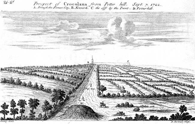
CROCOLANA, from the drawing by Dr. Wm. Stukeley, 1722.
ROADS are a fascinating study. From the primitive track of the African savage to the modern concrete motor road there is a vast gap, which marks as great a difference in civilization as it does in the methods of communication. Good roads and good road construction, though not necessarily indicating a high degree of civilization, are the mark of a practical and in all probability a conquering race; and among the great road makers of history there are two outstanding examples—the Roman and the British Empires. Yet we can only lay claim to the road as a test of civilization in the last hundred years or so. For fourteen hundred years the Roman roads had to serve our ancestors and were immeasurably the best and often the only roads in the country. Even at the present day our finest motor roads have for the most part a Roman foundation and direction.
The Roman road was essentially a military institution; it was planned originally to enable the legions to move with the utmost celerity from place to place, and in order to fulfil this object it ran straight, taking no heed of natural obstacles unless they were completely impassable. Even nowadays, when the point arises as to whether a road is of Roman origin, the first question that is put is: "Is it straight ?" In addition to straightness, however, there is another essential factor to speed on all roads, namely, a good and dry surface, which again necessitates a firm foundation, and it is this factor in which the Romans excelled as road builders; the Roman road-foundation lasted for all time.
All the surface soil was removed down to the fresh and unweathered ground, and on this surface a layer of rather large stones was succeeded by six inches to a foot of coarse concrete topped with fine concrete, and, finally, larger paving stones might be superimposed. This process is only to be seen in the finest examples of Roman roads in Britain; sometimes a fine gravel was used instead of the concrete, whilst the use of paving stones is not so frequent, although it was employed wherever possible, especially in stony districts. A very fair idea of the foundation of a Roman road can be seen in the section of the Fosse Way on the summit of Cotgrave Hill, showing layers of gravel, varying from coarse gravel at the base to fine gravel for the surface of the road. The effect of this foundation is to raise the road to form a small embankment or causeway, especially in low-lying districts, and many of these Roman roads can be traced at the present day by such slight elevations in the ground, as, for instance, the line of the original and early part of the Fosse Way near Margidunum may still be seen in the fields and is known locally as the "hump."
Nottinghamshire is not well endowed with the magnificent highways built by the Romans nineteen hundred years ago, for it preserves only two trunk roads which are definitely Roman, and of these two the great highway running from Leicester to Lincoln, known as the Fosse Way, is by far the best known and the most important at the present day. The other road crosses the north of the county, running from Lincoln (Lindum) to Littleborough (Segelocum) and thence through Sturton-le-Steeple, North Wheatley, Clayworth and Bawtry to Doncaster (Danum). This was a branch of the Ermine Street from Lincoln to York; on the east side of the river Trent where it is disused, it goes by the name of Till Bridge Lane.
The Fosse Way is still one of the most striking relics of the Roman occupation of Britain, for nowhere else in this country can a road be found running almost dead straight for 200 miles, viz., from Seaton on the Dorsetshire Coast, through Bath and Cirencester to Leicester and Lincoln. It was no mean feat at the period of the Roman Conquest to survey and drive such a highway through a hostile country, devoid of conspicuous landmarks, and covered with vast tracts of dense, primeval forest and still wilder districts of bare heath and moorland.
It would appear that the Fosse Way had a greater significance than being merely a means of communication from one town to another, and that it was originally constructed as a strategic road and military boundary during the conquest of Britain. For Tacitus in his Annals (XII, 31, 2) states that Ostorius Scapula, the Roman general in command in A.D. 46, "kept the enemy in check by erecting forts on this side of the rivers Severn and Trent." This passage, taken in conjunction with archaeological evidence as to date provided by the excavation of the early Fort of Margidunum, seems to indicate that the Fosse Way was laid down by Ostorius Scapula as a frontier-line from S.W. to N.E., right across Britain, and as a base of communications from which he could wage war on the British both to the east and west of the line. Such a road, with forts built at frequent intervals, was an excellent means of holding down a country and erecting a barrier between hostile tribes. Now in the best-known part of the Fosse Way, namely, between Leicester and Lincoln, we find Roman forts occurring at regular intervals of 13½ miles, with occasional half-way stations; on this section, described in the "Sixth Iter of the Antonine Itinerary" (a Roman road-book compiled in the latter part of the second century), four stations are given between Leicester and Lincoln, viz., Ver-nemetum, Margidunum, Ad Pontem and Crocolana (or Crococolanum), whilst the return journey (given by the Eighth Iter) leaves out Ad Pontem. The average distance between these forts is about 13 miles, with Ad Pontem occurring at the half-way mark between Crocolana and Margidunum. Here, therefore, in Nottinghamshire there is a speedy means of communication between frequent military forts, which implies (as already indicated) that the Fosse Way was originally a military frontier-line combined with a base of operations. This average distance of 13 miles between forts occurs on other Roman roads, e.g., on the road between Manchester and Templebrough, near Sheffield. Here the distance from Templebrough to Brough in the Peak district is 13½ miles and from Brough to Melandra Castle is another 13 miles, and the same distance lies between Melandra and Manchester. This interval of 13 miles between Roman stations is, of course, not a hard and fast rule, but it does seem to occur on roads which were originally military in character. It is a curious coincidence that an African porter at the present day considers 13 miles to be a fair day's march, and for a fully laden man such as a Roman soldier this distance would seem to form the most convenient marching stage under ordinary conditions, although it could naturally be increased in times of necessity.
The original Fosse Way would seem to have run in places a little to one side or the other of the present line, according to the most advantageous lie of the land, keeping to the higher ground wherever possible. For instance, a little to the north of Margidunum, about 100 yards west of the road, there is a well-defined ridge running through the fields. It is about 20 feet wide and is still known as the "hump"; and still further north, between the Red Lodge Inn and the right-hand branch road to Flintham, the old and original line of the Roman road can again be traced on the west side of the present road for about half a mile along the higher ground.
The only evidence now in existence as to the original width and construction of the Fosse Way is afforded by the section on the top of Cotgrave Hill. Here the road would seem to have been 18-20 feet wide with a coarse gravel foundation and a top-dressing of finer gravel. Originally it may have been paved in places where stone was easy to procure for that purpose, and near Cotgrave, Stukeley mentions "great blue flagstones laid edgewise very carefully." Elsewhere he says the road was paved with smooth flints set upon a bed of gravel. All traces of paving, however, have been obliterated, for the road seems to have been used as a quarry, since the same authority in 1722 stated that in some places people "dig the very stone and gravel out of it to mend their streets." Stukeley's prints of the road show a trackway in poor condition between hedges about a hundred feet apart, and until recently the stretch from Cotgrave to Six Hills was swampy and in a very bad state owing to the blocking and obliteration of the deep drainage ditches which originally bordered the road.
The positions of the forts on the Fosse Way in respect to present-day names is indicated on the map. The site of Ad Pontem, once a subject of fierce controversy, may now be fixed definitely in the field on the east side of the present road opposite Stoke Hall, where the mound of the western gateway can still be seen and Roman pottery can be picked up on the surface of the field, whilst the original road can be seen leaving the western gateway of the camp as a well-marked ridge or causeway. The name Ad Pontem has been taken to indicate a bridge across the Trent, but the land on the opposite shore is liable to flood, and a high causeway here would be necessary, of which there is no trace. It may, therefore, be suggested as an alternative that the Fosse Way on proceeding northwards from Stoke ran over a series of culverts across the marshy area between Stoke and Newark, and hence the camp derived its name of Ad Pontem. British roads in Africa to this day are constructed over swamps by means of a high embankment pierced by culverts. The causeway which can be traced to the north of the camp at Stoke is well marked and is still of a considerable height.
The other definitely Roman road across the county from Lincoln to Doncaster is less known, although the route can still be clearly traced and is distinctly marked on the Ordnance map. This road would seem to have been a branch of the Ermine Street, being preferred perhaps to the more direct road to York, which involved a crossing of the Humber. This road leaves the Ermine Street just north of Lincoln, crosses the Trent at Littleborough and continues via North Wheatley through Bawtry to Doncaster.
There is plenty of evidence for the Roman origin of this road apart from the obvious line shown on the Ordnance map. The Fifth and Eighth Itinera of the Antonine Itinerary give the route for both the northward and southward journeys; and the distance from Lincoln (Lindum) to Littleborough (Segelocum) is given as 13 miles and that from Littleborough to Doncaster (Danum) as 21 miles. At Littleborough the Roman settlement was on the west bank of the Trent, practically where the modern village now stands. Here in the Trent at low tide in a dry season portions of the Roman causeway can still be seen quite clearly. There does not seem to have been a bridge. The causeway is about 18 feet wide, with a margin of large stones, and it was originally staked on either side by oak poles, but the greater part of this causeway has been removed for purposes of navigation. There is, however, a solid portion of the paved descent still visible on the western bank. An altar and numerous other finds have been discovered at Littleborough and Roman remains are to be found along the whole length of the road, whilst at Styrrup a Roman villa has been excavated. From Bawtry onwards the road seems to adhere to the present line of the Great North Road.