
< Previous
SNEINTON CROSSROADS:
A View From the Sixties
By Stephen Best
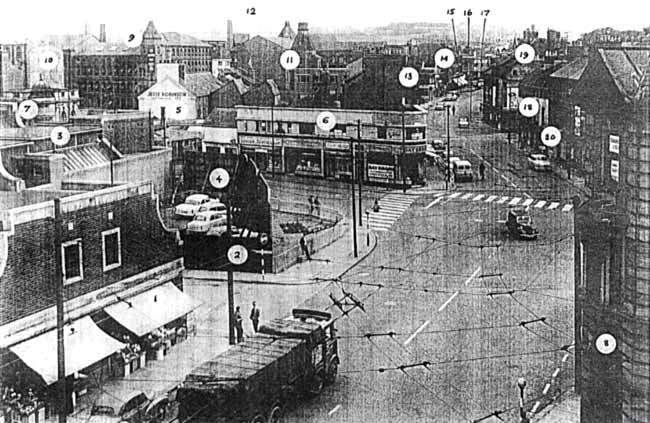 VIEW FROM TOP OF BUS DEPOT 1963
Wholesale market on left: Salvation Army Men’s Hostel at left background. Bath Street is in the centre
THIS BIRD’S-EYE VIEW WAS CAPTURED by the late George Roberts, who as a member of the staff of Nottingham Local Studies Library photographed innumerable scenes now lost to the city. To gain this particular vantage point he must have had access to the roof of the City Transport depot offices.
The date of the picture is August 1963, and Harold Macmillan’s six year tenure as prime minister has just two months to run. In the United States John F. Kennedy’s presidency will end on 22 November in his fatal visit to Dallas. Throughout Britain the Beatles are enjoying phenomenal success as a pop group.
Here in Nottingham a three-bedroom house in Sneinton Boulevard is on the market at £850, while £3,995 is being asked for an ‘immaculate’ five-bedroom home in Mapperley Park. A local department store is offering £1,000 a year for a fashion buyer, but other jobs advertised in the Evening Post are not nearly so well paid. A kitchen maid at the General Hospital earns £7.9.0d (£7.45) for a 42-hour week, and a junior clerical assistant with Carlton Urban District Council enjoys a starting salary of £270 a year. A new Ford Zephyr car is priced at £790, while a nine-gallon cask of Whitbread’s Bitter may be had for £6 at Burton’s of Smithy Row.
The Nottingham Playhouse in Goldsmith Street has recently closed its doors for the last time, and the city awaits the opening in December of the new theatre building in Wellington Circus. Although the number of Nottingham cinemas has dwindled noticeably over the past decade, fifteen remain open in 1963 to list their programmes in the paper.
Nottinghamshire’s new opening batsman from Yorkshire, Brian Bolus, is on his way to becoming the highest scoring batsman of the season, and has just been selected for England against West Indies. Many Nottingham people still go on holiday by rail, and trains to and from the seaside swell the total of summer Saturday departures from Victoria Station to nearly sixty.
Although much of what appears in this photograph still survives forty three years later, a good deal has gone. The camera is, of course, looking up Carlton Road, with, in the immediate foreground on the right, the Westminster Bank at the corner of Manvers Street. Across the road is the wholesale market, with the bottom of Bath Street just beyond.
Quite what we should call the thoroughfare in the foreground is a bit of a puzzle, Somehow one always thinks of the entire length of road between Lower Parliament Street and the Bath Street/Sneinton Road junction as Southwell Road, but it is not as simple as that.
Properties in the very short stretch between Manvers Street and Sneinton Road on the right- hand side of view - the invisible end of the zebra crossing is at the foot of Sneinton Road - possessed Carlton Road numbers, the bank being no. 2. On the left-hand side, however, matters were a little different. Here Southwell Road numbering used to go up as far as Finch Street - predecessor of Freckingham Street in the picture - while the short distance from there to the Bath Street corner was described in directories simply as ‘Sneinton Market.’
The odd-numbered side of Carlton Road thus began at the far corner of Bath Street, some thirty or forty yards further up the road than the start of the even side. For the sake of clarity, though, I shall follow local usage and treat all the road between the camera and Bath Street as Southwell Road.
The photograph was evidently not taken on a Sunday, as the fruiterer’s just beneath the camera is open, and a further half-dozen shop blinds are in position. One or two lorries parked by the kerb higher up Carlton Road also suggest a weekday. Compared with today, the amount of traffic is minimal, but what there is gives a strong flavour of the fifties and sixties. The big twelve-wheeler lorry is passing a Morris Minor 1000, while a Ford Prefect turns out of Bath Street into Southwell Road. The reader may recognize other cars of the period at the roadside or behind the hoarding. A cyclist tackles the slope of Carlton Road, while a pedestrian with hands in pockets appears to be taking his time in crossing the road farther up.
A handful of bystanders enlivens the scene. Two young men watch the passing traffic from the corner of Freckingham Street, while a third leans against nearby railings. If that is a suitcase beside him, he may be awaiting a lift, but I think the object may be just a box. Just around the corner are two more people doing nothing, one of them a man in a flat cap. Could they all be waiting for opening time? There were certainly plenty of pubs within a very short walk of this corner. Only two of these - the Duke of Devonshire and the White Lion - appear in the photograph. They will be mentioned in more detail later on.
Missing from the scene is any sort of public service vehicle. This is a pity, since Sneinton was in 1963 still very much a part of the Nottingham trolleybus network, as evidenced by the overhead wiring. The first trolley route had been converted to ordinary bus operation in 1962, but the others would not be dismantled until 1965 or 1966, when Nottingham’s last ‘trackless’ ran.
Here we see a spot where two busy routes coincide, and which also sees the sporadic passage of trolleybuses leaving Parliament Street Depot (usually referred to locally as Carter Gate,) to go into service. The 44 route from Bulwell Hall to Colwick Road comes down Bath Street, turns right, and then immediately left into Manvers Street. The westbound service 39 from Carlton Post Office Square to Wollaton runs down Carlton Road towards the camera, crossing the 44 route underneath the impressive array of overhead gear in the picture. The eastbound Wollaton - Carlton journey, however, bypasses this location, using Handel Street as a one-way link between Bath Street and Carlton Road. It joins the latter at a spot between the two pubs already referred to, which are just visible at the top of the photograph.
The fruiterer’s in the left hand foreground is structurally part of the ‘new’ Sneinton Wholesale Market, then only 25 years old. This site was previously occupied by a grid of streets, almost entirely comprised of cramped and insanitary back-to-back dwellings lying between Gedling Street and Southwell Road. For some years the City Council had been anxious to get rid of Nelson Street, Pipe Street, Lucknow Street, Brougham Street, Sheridan Street, and Finch Street, but it was not until 1934 that demolition began. Virtually every building in this area disappeared, with the prominent exception of the Fox and Grapes pub - now the closed-down Peggers - at 21 Southwell Road, just off the photograph to the left.
Late in 1935 the Council approved a plan for replacement of the existing wholesale market, which had been moved here from the Great Market Place in the summer of 1900, and was housed in a collection of what cannot have been very hygienic sheds, erected between Sneinton Retail Market, Bath Street, and Finch Street.
The new wholesale market was of course an immense improvement on the old, the sections devoted to fruit, vegetables and flowers coming into use in June 1938. The old street names fared badly in this renewal. Although Nelson Street was allowed to retain its name after modernisation, its new neighbours became nothing more exciting than Avenues A, B and C. The avenue built nearest to the site of the old Finch Street has, as already mentioned, a more interesting name. Freckingham Street is so called after Alderman John Henry Freckingham, chairman of the Markets and Fairs Committee, who officially opened the flower, fruit and vegetable sections on 16 June 1938.
The fish market was not opened until a year later, just before the outbreak of war. Occupying Avenues D and E, it was laid out at right angles to the other blocks, between Freckingham Street and Bath Street. There used to be a plaque in the market recording the market’s opening, but this has sadly disappeared in recent years.
The market site became increasingly congested for the amount of business it was doing, and in 1957 extra space was made available in the ground floor of the telephone exchange in Gedling Street. By 1995, however, it was time to move to a new site in Clarke Road, near the Eastcroft incinerator, and behind the Cattle Market. The former wholesale market has become Sneinton Square, the individual stalls being let to a variety of small businesses. There have, unfortunately, always been too many empty and shabby units for the venture to be considered a complete success.
The retail fruit stall in our picture is at 25 Southwell Road (1), for many years owned by Frank Sims. Freckingham Street is, as the two traffic signs show, one-way only, with traffic permitted from the Gedling Street end (2). Immediately above the fruiterer’s can be seen the parapet of a public lavatory in Freckingham Street, and above that the louvred roof of one of the fish merchants’ stalls in Avenue D (3).
The Bath Street corner is graced by an advertising hoarding set diagonally across the site. Following the prevailing fashion of 1963, it has some rather puny planting in front, in an attempt to persuade the public that it is an ‘amenity.’ The camera angle reveals the struts holding up this bit of street scenery, behind which the inevitable parking space has been created (4).
At the time of writing, late summer 2006, the left-hand half of the former fruit stall has just been taken by Dan, whose fascia reads: ‘African Food - Quality Kwanga.’ The other side, however, remains unoccupied since the departure of Caribbean Fried Chicken. A modem building now stands on the site of the hoarding at the Bath Street corner. Currently the home of Tropics (aquaria, pets, aviaries, etc.) this was previously the premises of Jesse Robinson, fish fryers’ sundriesmen. As can be seen in the photograph, Robinsons are by 1963 already well-established in the neighbourhood, having premises in Bath Street, and around the corner in Longden Street, where their name is boldly displayed (5).
The opposite corner of Bath Street does little more to raise the spirits than does the advertising hoarding. This site was once filled by the Albion public house: massive and cheerful, with a tall curved gable turning the corner into Carlton Road. Closed in 1934, the pub was soon afterwards demolished, to be replaced by a row of shops which no doubt appeared very modem at the time. By 1963, however, this glum little block is already looking fairly down-at-heel (6).
On the corner is the once-familiar Daybook Laundry and dry cleaners, late the Ideal Laundry service. The next-door premises accommodate a ladies’ hair stylist, while another Nottingham old faithful can be seen at no. 6: during the 1950s James Coombes’ shoe repairers had had seventeen branches in the Nottingham area. Ron’s gents’ hairdressers occupies the end shop in the block, displaying a big advertisement for Senior Service cigarettes, and the tiny and much older building is John Pownall’s antiques and second-hand shop. This name was very familiar in Nottingham, the famed Jacky Pownall being regarded as a prince among scrap merchants.
In 2006 the place of the laundry on the corner of this rather woebegone block is occupied by Susan’s Sandwich Bar, but the former ladies’ hairdresser’s premises has been insensitively converted by the bricking-up of its shop window. Coombes’s old cobbling premises are now Bubbles Spa massage, and the former gents’ hairdresser’s is unoccupied, its most recent tenants having been the Haven Housing Trust shop, who followed S. & J. Spare Parts here. Men can still have their hair cut nearby, though, as EKO Barber’s Shop now plies its trade in Pownall’s former building at no. 10.
Just above the roof of the fish stall (now disused, like the men’s lavatory in front of it) can be seen the little dome embellishing the Midland Bank at the corner of Bath Street and Longden Street (7). This was one of five bank branches which surrounded Sneinton Market at the time, mainly serving market traders and other nearby businesses. All five buildings survive in 2006, although none functions as a bank any longer, the Midland now being Allen Joyce Architects. Others were the National Provincial at the corner of Handel Street (now empty, but most recently Sofa So Good, second-hand furniture:) Lloyd’s in Southwell Road (which has lately changed hands several times, and is currently Nottingham Disco & PA:) and Barclay’s (now Bunker’s Hill pub) at the bottom of Hockley.
The fifth bank is the one mentioned earlier, close to the camera in the right-hand foreground of the photograph (8). Designed by the architects Swann and Wright of Wheeler Gate, Nottingham, it was opened at the end of 1908 as a branch of the Nottingham & Nottinghamshire Bank. Eleven years later this company was absorbed into the London County, Westminster and Parr’s Bank, and by the time of the photo was of course the Westminster Bank. In 1969 this became the National Westminster, later NatWest. The branch closed in the 1990s, and now houses the Denture Clinic, with a firm called Titanic Diving upstairs. Here in our 1963 scene the top floor is occupied by Chambers & Son, ladies and gents’ tailors, whose business is advertised on placards in the window.
We return to the upper top left-hand part of the photograph, to the previously mentioned sign on the gable end of Jesse Robinson’s Longden Street premises. Behind this building, in Aberdeen Street, is what looks like a tall factory, with a corner turret topped by a conical roof (9). On this turret is a board which reads: The Salvation Army Hostel for Men. As late as the 1970s this hostel provided accommodation for 132 men, and also housed an industrial therapy workshop for men with learning difficulties.
The building was indeed originally a hosiery factory, fulfilling this role until acquisition by the Salvation Army just before the Great War. Across the road from it is another factory, its end wall clearly showing the roof slope of another vanished industrial building which had formerly abutted against it (10).
From 1886 to 1914 this was occupied by George William Bancroft’s lace frilling manufactory, famous for making nurses’ caps. Bancrofts moved in the latter year to the huge factory at the corner of Roden Street and Robin Hood Street, built in the late 1860s for the silk throwster William Windley, and situated about 100 yards off the picture. This building overlooking Victoria Park, where Bancrofts specialized as blouse manufacturers, has recently been converted into apartments.
The old Aberdeen Street factory vacated by Bancrofts was for many years tenanted by the Nottingham Making-Up Company. It, too, has now been demolished. The Salvation Army hostel across the road also has gone, together with the factory attached to it, their site marked today by the car parking space lying between Longden Street, St Luke’s Street, Handel Street, and Aberdeen Street. In spite of laudable attempts to soften this area by tree planting, it is now a sadly empty heart for this unsung corner of Sneinton. The immediate neighbourhood is far from beautiful, but a walk round it reveals several buildings worth more than a passing glance.
The photograph shows several factory chimneys in the immediate locality, all of them now dismantled. To the right of these can also be seen the boiler house and chimney stump of another factory (11). Only a few years before the picture was taken, this chimney, with a cap of magnificent fancy brickwork, had stood to its full height. It is seen here at the rear of the rather fine Victorian factory which turns the corner from St Luke’s Street into Longden Street.
In 1963 this factory is known as ‘Tomahawk Works,’ home of T.H. Knightall Ltd., hosiery manufacturers. The building, with the remains of its chimney substructure, can still be found in 2006, just behind the Earl Howe pub in Carlton Road. The factory, with its 1866 date stone, has received new windows, now bears the name Longden Mill, and at the time of writing is in the course of conversion into apartments.
On the print of the photograph in my possession, a faint, humped shape is just discernable on the skyline between the third and fourth factory chimneys from the left (12) . This is St Bartholomew’s church on Blue Bell Hill Road, which was pulled down in 1971, in common with many of the houses in its parish.
The remaining area of interest lies in the top right-hand part of the scene, the stretch of Carlton Road from the Bath Street/Sneinton Road junction to Alfred Street. In spite of a degree of decay since 1963, the western (left- hand) side of the road has undergone comparatively little structural change over the ensuing forty years. With the help of a magnifying glass, several landmarks can be made out. At the corner of St Luke’s Street, just to the left of the man crossing Carlton Road, can be seen the two tall gables, oddly topped by grey stone chimney stacks of the former St Luke’s Parish Schools (13). The PDSA had premises next door for many years [see note at end of article], and the old school was for a time in the 1950s also used by the Russell Boys’ Club.
On the facing corner of St Luke’s Street is a little row of shops dating from the late 1920s, which form the Carlton Road frontage of the Nottingham City Mission just around the corner. This attractive little composition (14), designed by the Nottingham architect A.J. Thraves, who was also responsible for the Palais de Danse, occupies the site of St Luke’s church, closed in 1925 and demolished very soon afterwards. At the time of the photograph in 1963 the shops consist of a branch of Nottingham Trustee Savings Bank, The Baby Shop, and the premises of Thomas Kirk, house decorator. They are easily picked out by the Dalek-like lantern on the highest ridge of the roof.
A couple of doors further on, the sunblinds are out at, I think, the old established firm of Whitings the pawnbrokers (15). Beyond these, at the corner of Handel Street, the rebuilt Duke of Devonshire pub, locally ‘the Madhouse,’ is identifiable by its little dome, which echoes the one on the Bath Street bank (16).
All these buildings still stand in 2006, though some of them are now put to new uses. The old St Luke’s School is in reasonable condition, even though its gables are now chopped off at the level of the bases of the chimney stacks. After being for over three decades the headquarters of the Tennant Rubber Co., who moved here from Fisher Gate, this building, too, is undergoing conversion into apartments and retail space. The City Mission building is used today by the Congregation of Yahweh, and the little row of shops along the frontage of the mission has been incorporated into this place of worship. The foundation stone survives, dated 19 October 1926. Next door, a pleasant building with stepped gable has in recent years become the Moot Hall pub.
The old Whitings premises are tenanted by the Job Centre and the Renewal Trust, while the Duke of Devonshire continues in business at the end of the block. A painted board explains the pub’s nickname. The General Lunatic Asylum, founded in 1810, stood across the road, at the top of what is today King Edward Park, and its patients are said to have been allowed out with friends and family, and to visit the original Duke of Devonshire pub on this site. During the nineteenth century the asylum operated a remarkably enlightened regime, which included a varied diet for inmates: and any employee mistreating a patient was severely dealt with.
At the corner of Alfred Street South and Carlton Road can just be seen a flat-roofed building (17). This is another renewal of very old licensed premises, and although nobody could call the present White Lion a lovely building, it does have a long and interesting history, especially in connection with early cricket in Sneinton.
In the summer of 1839 the White Lion Cricket Club issued a challenge in the Nottingham Review to the Basford and Hyson Green clubs, to play a match for a purse of ten
or twenty pounds a side. Three years later, a match between Sneinton and Carlton took place at the White Lion ground, resulting in a victory for Sneinton by 30 runs. This fixture was held on 16 October, which says something about the subsequent change in climate, or the hardihood of old cricketers. Some years ago the White Lion succumbed to the craze for pub renaming, and was burdened for a while with the name ‘Alfred’s.’ Happily, the old name was restored in due course.
The opposite side of Carlton Road has, however, changed out of all recognition. Here we see some of the oldest buildings in New Sneinton, erected in the 1830s, and at the time of the photograph having only a few years of life left in them. Several have the long upper windows which indicate a framework knitter’s workshop, where maximum light was required by the operator at the knitting frame.
A number of the businesses seen in the picture have traded here for many years, among them Hutchby’s newsagents and wholesale tobacconists at 26-28 Carlton Road. This shop is at the nearer corner of North Street, the first turning on the right in the photograph (18). Mr Les Hutchby of this business had been a friend of my father since their time together in the Boys’ Brigade at Dakeyne Street Lads’ Club. I remember being taken into the shop as small boy, and thinking the interior crowded and Dickensian. Some of the buildings backing on to these shops were equally fascinating. The photograph shows the delightful pantiled roofs to Hutchby’s and its next-door neighbours, with the gently sloping roofs altering to a steeper pitch halfway between ridge and gutter.
Like several other shops in the photograph, no. 30, on the other corner of North Street, appears to be already closed down. Painted on its end wall above the large poster is an advertisement, of which the words ‘Woods’ and ‘Biscuits’ can just be made out on my print.
These mark the premises of Elizabeth Woods, com and flour dealer (19), successor to Crofts Brothers, who had previously carried on the same trade here. As I know from another photo,
the full wording of this painted advert is ‘WOODS SELLS AND RECOMMENDS SPRATT’S BISCUIT DOG FOODS’ The letters of the word Spratt’s were, as many will remember, formed in the shape of a Scottish terrier. The rear of Woods’ shop and its neighbours was especially interesting, with an old industrial building behind no. 34 which, so I was told many years ago, had been a nail making workshop.
Closer to the camera, no. 22 is a greengrocer’s and fruiterer’s, run during the 1950s by Philip Bentley (20). An outdoor display of his wares (or a successor’s) is, I fancy, visible on the pavement just above the roof of the car parked on the right hand side of the road just beyond the zebra crossing.
Every building on this side of Carlton Road between Sneinton Road and Walker Street was obliterated during the Sneinton redevelopment of the late 1960s, and their site soon afterwards occupied by the existing small modem bungalows for elderly people.
The decrepit air of this row of old shops in 1963 is mirrored more than forty years later by the abandoned state of many of the shops on the other side of Carlton Road. As I write, little remains open between Bath Street and the Earl Howe pub, although until comparatively recently there were a post office, launderette, pharmacy, butcher and baker. There have been a couple of recent new businesses, but one would have to be a super-optimist to expect a complete revival here. It would be good to be proved wrong.
If this picture, and all the old views of the neighbourhood like it which have appeared in Sneinton Magazine since 1981, embody a message, it is this. Should a local scene interest you, please go and photograph it while you still can, for it may not be there this time next year, or even next month. Parts of the area seen in the picture will probably be swept away before long. And remember: the more humdrum and everyday the subject may seem, the less likely it is to have been recorded by anyone else.
NOTES
These other pubs near the Bath Street/Cariton Road/ Sneinton Road crossing included the following.
Bath Street
The Sir Robert Clifton is still open, but now called the Market Side, the name by which it has for many years been known locally. The Bath Inn was derelict for several years recently, but in spite of local pessimism re-opened as a pub a year or so ago.
Handel Street
The Vine was also closed for some time, but has since reestablished itself.
Carlton Road
The Earl Howe is still in business.
Sneinton Road
The Wheatsheaf, at the corner of Carlton Road, was demolished in the 1960s.
The New Inn, a little way up Sneinton Road at the corner of Haywood Street, was pulled down in the same decade. Confusingly, the modern pub now standing on the site of the New Inn is called the Wheatsheaf.
The Smiths’ Arms at the foot of Sneinton Road survives, but is now the Lamp, which is what locals used to call it anyway.
Manvers Street
The King William IV at the corner of Eyre Street closed down quite recently. There seems at present little likelihood of this very old Sneinton pub being revived.
Southwell Road
The derelict Fox and Grapes in Southwell Road still stands at the edge of the old Wholesale Market. As mentioned above, the pub last traded as the Peggers. The building is almost certain to disappear as a result of the forthcoming East Side redevelopment, as is the entire market site.
There were of course other pubs almost as close to the Southwell Road /Bath Street junction as the above were. One of these is The Fox, which has been empty for a year or more as I write. Small local pubs in cities do face economic difficulties, and there are also cultural reasons why nowadays fewer Sneinton residents are potential pub users. Nonetheless, it defies credulity that this very old public house cannot be made to pay. Lying as it does at the heart of Sneinton’s historic core, across the road from the church and almost within the shadow of the windmill, it seems ideally sited to catch passing trade from visitors in search of food and drink.
I had always believed (and written) that the old St Luke’s School building had formed part of the PDSA premises based next- door at 25 Carlton Road. This, however, now appears doubtful, and my memory may be at fault Enquiries and investigation have proved inconclusive, and informants with memories of the locality have offered contradictory accounts. I would be grateful if any reader can reliably state what the old school was used for before being taken over by the Tennant Rubber Co.
I am grateful to Nottingham Local Studies Library for permission to reproduce the photograph which is the subject of this article.
< Previous