
< Previous
HARDLY TO BE SURPASSED IN MISERY:
Parrott's Place and its times
By Stephen Best
'Some parts of Nottingham are so very bad as hardly to be surpassed in misery by anything to be found within the entire range of our manufacturing towns'. (J.R.Martin 1844)
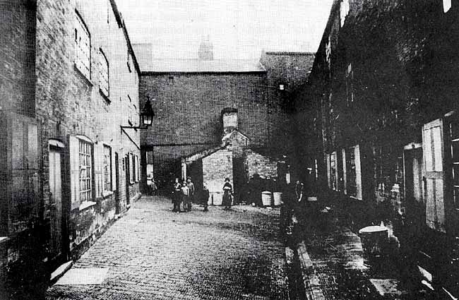
A PHOTOGRAPHER from Nottingham Corporation Health Department has set up his camera in Parrott's Place, probably sometime in 1931, drawing to the scene a couple of residents and a handful of neighbouring children. The latter are nicely posed, contrasting happily with their grim surroundings. Parrott's Place lay between Brook Street and Bath Street, and was reached through tunnel passages beneath houses at either end. These stood in Freeman Street and Corn Street, both of which led up from Brook Street towards Bath Street. Redevelopment and rebuilding of the area make it slightly difficult to pinpoint the spot in the landscape of Nottingham in 1994, but the site of the houses seen here lies, partly on the north side of the present-day Brook Street, and partly in the roadway itself, between the Huntingdon Street Sorting Office and the BT buildings across the road. Just around the comer is Cowen Street, featured in Sneinton Magazine no. 48. 1931 is certainly the likeliest date for the picture; at a Special Meeting of the City Council on March 2nd of that year, Parrott's Place was scheduled as part of Colwick Street no. 2 Clearance Area, and a compulsory order issued.
Parrott's Place was a funnel-shaped confined space containing nine back-to-back dwellings; it is worth repeating what this meant, as the term is often misapplied nowadays. Back-to-back houses were built with only one outside wall; they were joined by other houses, not only on either side, like thousands of terrace houses which survive in Nottingham today, but also at the back. Their rear wall was, therefore, also the back wall of a house in a neighbouring street or yard.
Built just after 1830, Parrott's Place is first found listed in an 1832 directory of the town. Its houses exemplified Nottingham's infamous practice of erecting slum houses, not even in the most cramped of streets, but in courts blocked off at the ends by 'front houses'. With the boom in the lace trade in Nottingham in the 1820's, the so-called 'twist net fever', so many workers had flocked into the town, and so scarce had land become, that the space required for a new street was begrudged by builder or developer, and solutions like the one illustrated were resorted to. Although there was at this date plenty of open common land surrounding the built-up area of Nottingham, it was, in pre-Enclosure days, given over to the use of the Freemen or Burgesses of the town, who enjoyed the right of grazing animals on it, and, in order of seniority of Freeman, could be allotted small parcels of land for their own use. The inhabitants of Nottingham as a whole were allowed to use this land for recreation, but from October to March it was of very limited value in this respect. There had been calls for the enclosure of this common land as early as 1787, but a candidate standing on this platform was heavily defeated. The Freemen, defending what they conceived to be their own vested interests by blocking any move to make building land available on the common land, found allies in the owners of small plots of land in the built-up town, who could see their pockets being hit if cheaper land for housing became obtainable on the undeveloped fields. So it was that Nottingham's population grew from about ten thousand in the middle of the eighteenth century, to 50,681 by 1831, without any real expansion of the town's built-up area. It was estimated that, of the 12,661 houses standing in Nottingham in 1841, more than a quarter (3,617), had been built between 1821 and 1831. A little earlier, it was reported that there were between seven and eight thousand back-to-back dwellings in the town. These were hurriedly erected, much more for the enrichment of the builder than for the health of the occupant. After the passing of the 1845 Nottingham Enclosure Act, the building of back-to-backs in the town was prohibited, and building was permitted on the common lands in the Meadows, the Clay Field (what we now think of as St Ann's), and the Sand Field (roughly the area between Shakespeare Street and the Forest). The Enclosure Commissioners, however, took twenty years to make their Enclosure Award, and in the intervening years much development took place which was far from desirable. That, though, is another story.
Even when newly built, Parrott's Place can hardly have possessed the elements necessary for an ideal home; as an instance of a back-to-back court development, its only access was, as already mentioned, by means of tunnel passages at each end. These were typically three feet wide, eight feet high, and some 25 feet long. Quite how residents were able to get their furniture in and out of such a cramped entrance is a puzzle; perhaps they had such pathetically few and insubstantial possessions that the problem rarely arose.
More seriously, these confined courts were desperately unhealthy, lacking the beneficial effects of a through current of air, and of sunlight. A few yards from the houses in the picture ran Brook Street, built, a few years earlier, on top of the Beck stream, culverted in the 1820s, and then serving as a main sewer. At this stage of the town's development, Nottingham's sewers were, on the whole, inadequate and unhygienic, and the Beck was no exception. In 1845, Thomas Hawksley, the great Nottingham water engineer, gave evidence to a Parliamentary inquiry; no man in the nineteenth century could have done more to save the lives of ordinary people in Nottingham through improving the town's hygiene, and his replies to queries are enough to chill the blood; 'The sewer formed on the course of the River Beck is even now incapable of conveying the waters of heavy rains, and has therefore occasioned the houses in its vicinity to suffer from inundation when these have occurred'. Add to this that the ground floors of these houses were of porous bricks laid on earth, and that none possessed damp courses, and the picture begins to take nightmarish shape. Even worse was the provision for the disposal of excrement. The photograph shows a group of outside lavatories at the Freeman Street end of Parrott’s Yard; by 1931 these had for some years been water closets, but at the time the houses were built they were the most appalling earth privies, middens, or ashpits. Readers anxious to savour to the full the details of Nottingham's dreadful sanitary arrangements of the nineteenth century are invited to read Peter Hammond's account in Sneinton Magazine no. 42; it is enough here to say that enlightened authorities of the time were outspoken in their condemnation of the system. It is a measure of the frightful nature of the earth privies that the town authorities felt very proud in the 1870s and afterwards when pail closets began to succeed them. These were emptied at stated intervals, ranging from once a day to every six days. By 1912 there were still some 12,000 pail closets left in the town, not all of which would be converted to water closets until 1923. Some houses, like the ones shown here, would have possessed decent flushable lavatories for only a short time before their demolition.
A further evil of the back-to-back systems was the existence of the 'blind-back' house, examples of which can be seen in the photograph. There was no reason why the Freeman Street houses across the end of Parrott's Place could not have been provided with proper windows at the rear, ensuring them of, at least, a healthy through draught. Such an opportunity was, however, ignored, and these dwellings have received only a couple of the pokiest peep-holes imaginable. As we look at the picture, we must picture the layout of the immediate surroundings of Parrott's Place. The houses on the left abutted on to similar back-to-back dwellings in Ivy Row, while the ones opposite shared a common rear wall with houses in Brook Street. The Parrott's Place homes were typical of their sort, with just three habitable rooms; on the ground floor was a communal living and eating room, and on each of the upper floors a single bedroom. Under the stairs would have been a cubby-hole for the storage of food and coal.
The water tap in Parrott's Court is a reminder of what would have been the sole source of clean water in the 1830s and 1840s. At this time it was quite common for one tap to supply a number of houses, but in many ways the provision of water was, ironically, one of the better features of Nottingham's sanitary provision. Thanks entirely to the heroic Hawksley, water was delivered under pressure through pipes, despite the incredulity of many great and good people, who believed that the feckless poor would inevitably steal the pipes and sell them for their scrap value.
When Nottingham was divided into municipal wards in the 1830's, Parrott's Place fell into Byron Ward. This contained some of the very worst slum housing in the town, including the notorious Meadow Platts area, on whose northern fringe our featured houses stood. Hawksley stated that, in 1845, the mean age of death in Byron Ward was 18.1 years, compared with 22.3 in Nottingham as a whole, and with a nationwide average of about 29 years. In Byron Ward, he calculated, the number of deaths of children under ten was double the rate in the more fortunate Park Ward of Nottingham. Adults who had not yet reached old age fared little better in Byron Ward; the occurrence of deaths of people below the age of seventy was, in Nottingham as a whole, 40% above the national average, while in Byron Ward it was an appalling 55% higher than the national figure.
When, in 1832, the town suffered an outbreak of cholera, the Meadow Platts was one of the worst affected parts of Nottingham. This district lay between Platt Street and the Beck stream, (in today's terms the land between Lower Parliament Street and Brook Street). Parrott's Place was within a few yards of this notorious tract of slums, which, like all the town's least healthy areas, was low-lying, and not built on the sandstone rock. After an epidemic of this sort, infected houses would be lime-washed inside and out to remove any lingering trace of disease, but it is unlikely that this made them any more pleasant to live in. Walls, as we have heard, lacked damp courses; they were often thin and porous, and foul water frequently ran or stood close to, or under, the homes of the poor. The previously mentioned shortcomings of the Beck sewer can only have made life in Parrott's Place even more hazardous. The photograph gives a further reminder, in the gully which crosses the court, of the sanitary arrangements endured by the original occupants of the houses. All surface water would once have been carried away by this; the one illustrated does not even lead out through the passage into the street, but appears to end (or begin) in the region of the lavatories. When one remembers that, in the 1830s, these would have contained foul and decaying waste matter, awaiting its value as manure to appreciate before purchase by one of Nottingham's 'muck majors', the plight of the residents almost beggars the imagination.
In his report on the Sanitary Condition of Nottingham in 1844, J.R. Martin described one locality in which 4,200 people occupied an area 220 years square; that is, one person to every ten square yards. This must, even for Nottingham, have been an extreme case. Parrott’s Place, though bad enough, was never quite as awful as the example just quoted. The census of 1851 affords us a glimpse of its occupants, at a time when the houses were just on twenty years old. All nine houses were lived in at that date, the most crowded home being that of William Foster at no. 1, A 31 year-old framework knitter, Foster shared the 3-roomed house with his wife Mary, his two stepsons, aged 11 and 7, and the couple's three younger sons, of 5, 3, and one. Besides the children at no. 1, thirteen other children of twelve and under lived in the Place: seven boys and six girls. Of these a 12 year-old girl worked as a lace mender, while a lad of 11 was employed as an iron- founder's assistant: Foster's elder stepson (in 1851 parlance his 'son-in-law') was described as a cotton winder. Five of the children listed were 'scholars', though, since one of these was only two years old, we may doubt the total accuracy of this description. The infant son of Alfred and Phebey (Phoebe?) Sheard at no. 2, by the way, bore the resounding Christian name of Hamlet. Sheard was a cordwainer (shoemaker), and three heads of households in addition to Foster were framework knitters. Other men worked as general porter, gardener, and iron-founder, and all the women giving occupations were in the lace or hosiery industries. Of the 42 residents of Parrott's Place in 1851, 27 were bom in Nottingham; Alfred Sheard and his elder son shared the most distant birthplace, Birstall in Yorkshire. Only three residents were over fifty, with a further six in their forties. It is evident, then, that none of the houses was noticeably overcrowded, though there must have been several instances of bedrooms being uncomfortably full.
We can compare the situation in 1851 with that of 1891, the latest year for which the census enumerators' returns have so far been made public. In this latter year, seven houses only in Parrott's Place were occupied, nos. 3 and 4 being empty on the date of the census. The population had decreased slightly, to 39, but, taking into account the empty houses, this meant that the average number of residents per home had risen a little. Nobody from 1851 was still living here, and the population of the Place reminded a predominantly young one. Two of the houses accommodated nine people. At no. 2, Joseph Johnson, a bricklayer's labourer, and his wife Martha, lived with their seven children, two boys and five girls. These ranged in age from 15 year- old George, who was out of work,to Victoria, who was 8 months old. All the Johnsons had been bom in Nottingham, as had the seven children of James and Charlotte Maltby at no. 9. The parents were natives of Derbyshire, and the eldest of their children was Florence (15), a lace hand; George, the youngest, was under a month old. John and Jane Danaghey at no. 7 had the comparatively rare distinction of having their house to themselves, though, as both were unemployed, they might well have been glad of a lodger. One lodger in Parrott's Place had come a long way; this was Daniel Painter, a 21 year-old wood chopper from Dundee, who shared no. 8 with his landlord, his landlord's son and two woman lodgers in their forties, both employed as shirt finishers. William Williams, the householder here, was the only resident at no. 8 who was unemployed. Of those of working age in 1891 at Parrott's Place, twelve were in jobs, and five out of work. Once again, most of the women were engaged in the lace and hosiery trades, while the men had such occupations as joiner, carter, and bricklayer's labourer. Nearly half of the Parrott's Place population of that date was made up of under-12s, no fewer than 19 such children living there. The progress in universal education since 1851 can be seen by the fact that fifteen of the children were 'scholars', while the remaining four were babies, the youngest under a month old. There were again only three over-50s resident, and just five people in their forties.
We leap a further four decades to 1931, the probable date of the photograph. Nottingham had seen many changes in the intervening years, and had, following the Great War, begun a massive programme of housing replacement. New estates had appeared on the outskirts of the city, beginning with the Stockhill scheme. The Garden Suburb ethos informed the planners, and the new Council houses offered standards of accommodation, with attractive gardens, that would have seemed like a dream to the residents of 1891. There were, though, still plenty of homes like those in the picture, or worse, to be demolished and replaced.
What can be gleaned from the photograph about the state of Parrott's Place and its inhabitants at the beginning of the thirties? The children all look cheerful and clean, and appear to be properly shod; one constantly has to remind oneself that poor housing conditions did not automatically imply scruffy, irresponsible families. The opposite was frequently the case, with parents working desperately hard to keep their families clean, properly fed, and healthy. The woman on the right is engaged on some cleaning task involving a bucket or tub; perhaps she is busy scrubbing out the handcart which rests beside her, its handles pointing up into the air. The cart looks as if it is homemade, fashioned from a simple wooden box. On the wall near the camera hangs a sweeping brush, evidence of more efforts to keep Parrott's Place tidy; there is, however, an unsightly scatter of litter around the dustbins and along the edges of the gully. We must not assume that the residents had caused this; marauding cats or local hooligans could have been responsible. The yard is paved with the once-familiar patterned blue bricks, of which a few examples can still be found in and around Sneinton. The houses themselves appear to be in pretty poor structural condition, with signs of damp all along the ground floors; the lavatory walls, too bear indications that they are wet and unhealthy. All the houses retain their original shutters, but, unless I am mistaken, none of them possesses a letter-box. Can this be the case? If so, the postman would have had a wearisome time knocking on every door. One gas lamp is the only illumination that can be seen, though there may have been a second behind the camera; it is almost certain that none of the houses had electricity laid on.
Pets evidently survived in these unpromising surroundings - the dog in the foreground has much too proprietorial an air to be a passing visitor on the doorstep. Someone had evidently made a solitary attempt at making Parrott's Place a bit less forbidding, as what looks like an abandoned window-box projects below an upstairs window; plants would at least have seen a little more light at this height than if left to struggle at ground level.
Six dustbins can be seen in the court; in 1931 these would have been more than sufficient to give each occupied house one to itself. The schedule for the Colwick Street no. 2 Clearance Area indicates that, in fact, only five of the Parrott's Place houses were lived in. We are, alas, not told the occupations of the residents, or how many people were in their households, but we know that the tenants were, at no. 3, Charles Smitham: no. 4, Miss Maria Silvana Phipps: no. 5, William Henry Brett: no. 6, Mrs Ada Wesson: no. 7, Mrs Ellen Gisby. The houses were all owned by John Russell, a former lace manufacturer, of 17 Zulla Road, Mapperley Park. Like many owners of slum housing, Mr Russell lived a good distance away from these properties. Does anyone survive who remembers any of these last occupants of Parrott's Place? It is over sixty years ago, but a child or grandchild may still be alive, who can recall something of the flavour of life here.
With the continued programme of housing replacement in the 1930s, Parrott’s Place and the surrounding streets were swept from the map soon after the photograph was taken. One hopes that all its residents found decent, affordable housing to live in. Every enlightened citizen no doubt breathed a sigh of relief to see the progress of the campaign against conditions like these, which placed a section of the community at such an appalling disadvantage. How outrageous it seems to us to read that, in a certain ward of Nottingham, people were more likely to die seven years earlier than the national mean age, and that three people in this ward below the age of sixty should die for every two in an 'average' locality. How dreadful, too, that residents of two wards in Nottingham should run almost 50% greater risk of dying before they reached 65, and were 2.5 times as likely to die of respiratory disease, than if they lived in an area of Nottingham with the average local death rate. Appalling and inexcusable, we say. Yet, while the first two statistics just quoted come from Thomas Hawksley's comments on Byron Ward in the 1840s, the last two refer to Manvers and Trent Wards, and were collated by Nottingham Trent University in the 1990s. Parrott's Place may be long gone, but it is not yet time for anyone to feel complacent.
THE PHOTOGRAPH is reproduced by courtesy of Nottinghamshire Local Studies Library, Angel Row, Nottingham
< Previous