
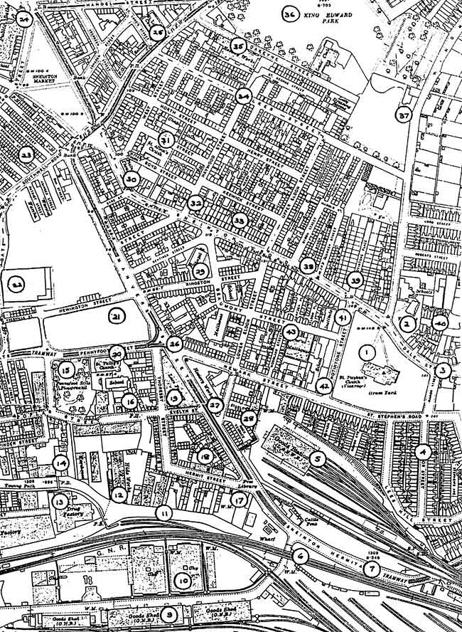
< Previous
TOTALLY LACKING IN CHARM:
Sneinton from the air in 1923
By Stephen Best
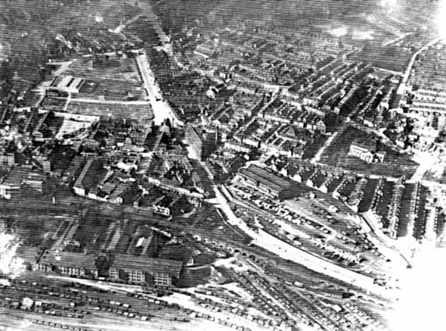
HERE WE HAVE what is probably the first photograph ever taken of Sneinton from the air. It was secured on a sunny afternoon some time during 1923, by one of the companies set up after the Great War to exploit the new market in aerial photography. This shot in many ways complements another taken in 1927 by Surrey Flying Services, which was the subject of an article in Sneinton Magazine no. 44. Some places appear in both views, but the one reproduced here shows many interesting parts of the neighbourhood not covered by the 1927 picture. The latter photograph concentrated on the site of the Nottingham Corporation Bus Depot in Carter Gate, seen here in the upper left of the picture, while the camera in 1923 appears to have been directed mainly at the railway installations on either side of Manvers Street, and at the factories and warehouses close by. Happily, it also provides us with an unrivalled panorama of the tightly packed and populous residential district of New Sneinton, lying between the church, Manvers Street, and Carlton Road. Of the buildings standing in this area 73 years ago, hardly a handful survive today, while the railway layout visible here, and the complex of industrial buildings, have all but disappeared. The fact that the photograph is fuzzy in places, with a variety of other technical imperfections, in no way detracts from the fascinating scene it reveals.
The old settlement of Sneinton is chiefly represented by the parish church (1) on its hilltop site. Apart from the crossing tower of 1839, St Stephen's as seen here is only just over a decade old, the body of the church having been rebuilt in the years before the Great War through the munificence of its incumbent, the Rev. and Hon. Robert Dalrymple, youngest brother of the 11th Earl of Stair, and vicar of Sneinton from 1902 to 1917. The light stonework of the new parts of the church stands out in sharp contrast to the soot-blackened tower. Despite its youth, the building, in its large wooded churchyard, is unmistakeably the focal point of Sneinton. To the north of the church, set back behind its garden at the corner of Windmill Lane, is the vicarage (2), just three years older than the church tower. Other remnants of Old Sneinton can be seen nearby, in the Fox public house (3), the adjacent cottages, and in St Stephen's Lodge at the corner of Manor Street: location, as it would be for another three decades, of Dr Sparrow's medical practice. Unfortunately obscured here by a blemish on the print, this attractive group survives in 1996, though St Stephen's Lodge has been sadly meddled with by builders in recent years.
Between the church and the railway lies a development of very late nineteenth century houses in streets such as Manor Street (4), St Stephen's Road, and Lees Hill Street; much of the land on which they stand formed, until its demolition in 1894, the garden and grounds of Sneinton Manor House, which lay on the extreme right-hand edge of the site shown here. Slightly older than these streets is Manvers Street Goods Station (5), laid out on top of the levelled - off sandstone rock overlooking Sneinton Hermitage, and opened in 1888 by the London & North Western Railway. Its construction necessitated lowering the surface of the rock by twenty-five feet, and the demolition of the rock houses that lay in the path of the railway bridge crossing the Hermitage. Since the grouping of British railway companies on January 1st 1923, it has been part of the London Midland & Scottish Railway, but the name of the new owners has not yet replaced that of the original company, just visible on the original print with the aid of a magnifying glass. The railway warehouse stands here as originally built; after air-raid damage in May 1941 it would be reconstructed with a flat roof. The main entrance to the goods station can be seen in Newark Street, just above the warehouse, while alternative access for vehicles is provided below the station in Manvers Street. This divides into two arms; a steep incline leads up to the station yard, while a tunnel (not visible here) runs from Manvers Street to a spot directly underneath the floor of the warehouse, where a hoist facilitates loading and unloading of drays and lorries into and out of the station. Manvers Street Station has over 40 years of life ahead of it, before its eventual closure by British Railways in 1966. A considerable amount of goods traffic can be seen in the yard; some seventy wagons are being dealt with, with timber apparently the main commodity. There are also wharves for the handling of mineral and livestock traffic, but there is no sign in the photograph of the banana vans which were conveyed to Manvers Street by fast goods trains, mostly running at night. The site of the station is in 1996 occupied by Newark Crescent, and only the huge retaining wall remains, with the abutments of the Sneinton Hermitage bridge, just off our picture on the right. The short Manvers Street Goods Branch was the only line in Nottinghamshire to have been owned solely by the North Western.
On the opposite side of Sneinton Hermitage lies another landscape created totally in the nineteenth century. The LNER (formerly Great Northern) viaduct (6) snakes along the south side of the road, on its way into Nottingham Victoria Station. For all its -dominance of the townscape, it was to have a working life of only seventy years or so. Opened in 1899, it would cease to carry passenger trains in 1967, hanging on precariously for about seven years longer as a stub of its old self for the movement of freight traffic. The railways completely altered the character of this part of Sneinton, and have now in their turn been almost entirely wiped from the face of the neighbourhood. The Great Northern viaduct, with its associated works, caused the resiting of the Sneinton Hermitage carriageway (7) to a line about 60 feet north of its old course, a piece of road building which brought about the final obliteration of Sneinton's famous rock dwellings to the west of the bridge. The last of these, the White Swan and Earl Manvers' Arms public houses, had gone by 1898. Despite wild, and frequently repeated, tales of their being the original homes of the followers of Snot, the supposed Anglo-Saxon founder of Nottingham and Sneinton, there is no mention of rock houses at Sneinton before the sixteenth century.
To the south of the viaduct are the busy goods yards (8) and warehouses of the Great Northern Railway, since the beginning of 1923 the LNER. The magnificent warehouse designed for the Ambergate Railway Company in 1857 by T.C. Hine of Nottingham stands (9) to the left of the early 20th-century Great Northern warehouse, which was to be extensively damaged by fire in December 1993. The volume of wagons being dealt with here reflects the extent to which the railways in the 1920s still dominate the carriage of freight in Great Britain, while the almost universal use of coal as a domestic fuel explains the presence of several coal merchants' sidings in the goods yard. Goods traffic was to be dealt with at London Road until 1967, with the yard lingering on for a further 20 years after that to accommodate parcels trains. Immediately above the warehouses can be seen retort houses and a gasholder of Eastcroft Gasworks (10), which was developed and enlarged on this site from the 1850s, and would continue to produce town gas until well after the Second World War. The land occupied by railway sidings to the right of the railway warehouses is now taken up by the new Manvers Street bridge spanning the the surviving railway line to Lincoln.
Beyond the viaduct the truncated Earl Manvers branch canal, named after Sneinton's chief landowner, runs towards the east (11). This extension of the 1835 Poplar Arm of the Nottingham Canal originally terminated at wharves at the Hermitage, but was shortened when the GNR viaduct was constructed. To the north of it lies a higgledy-piggledy collection of industrial buildings, with Hermit Street on their farther side. One warehouse has impressive arched openings, for convenient loading and unloading of canal boats, and a short distance away from it to the west is a long building with a hipped roof, its end wall highlighted by the sun. This is the hide works of the Nottingham Hide, Skin & Fat Market Co Ltd (12) in Poplar Square; animal by-products are an important industry around here, and its next-door neighbour is a sausage skin factory. The hide works marks the point at which the Brewery Cut branch of the canal leaves the Poplar Arm. Its entrance only dimly picked out by the camera, the Brewery Cut curves around Island Street to a dead end adjacent to London Road. A narrow basin runs alongside the length of the hide works, while the nearby buildings follow the diagonal path of the Brewery Cut, until it turns sharp left. All these branches form part of the Nottingham Canal, which shared the fate of many waterways in the 19th century, being bought up by a railway company (in this case the Great Northern). The railways found that owning a canal was often the quickest way to eliminate one of these rival concerns, by running it down to the extent that total closure became a foregone conclusion. In post-Second World War days, all the stretches of waterway visible here were to be abandoned, and their traces gradually obliterated. The last vestige of the Poplar Arm was closed in 1982.
On the extreme left of the photograph, Boots Island Street factory can clearly be seen, with huge lettering (not quite legible here), announcing it it to be 'Boots Manfg. Chemists' (13). First moving into Island Street in the 1880s, when they took over premises formerly used by Elliott's cottondoubling factory, Boots gradually acquired all the land in Island Street, occupying it with their own installations. Just above Island Street are two or three industrial buildings erected not long before this date, including the Boots power-station and cold store in Pinder Street, and Harvey's frilling factory in Plough Lane (14). Across the street from Harvey's is Pennyfoot Street playground (15). Opened in 1906, this little recreation ground, about three quarters of an acre in extent, and locally often called Cottee Park, was created on a bit of waste ground at the corner of Pennyfoot Street and Plough Lane, at a cost of £500. Children from local schools attended the official opening, and, as previously related in Sneinton Magazine, were all rewarded with a bun and an orange.
Along Poplar Street from the park can be seen premises housing Keetley's woollen waste merchants, Hague's hosiery factory, and the former Press Studs works, before the Poplar Tree public house is reached; this survivor into comparatively recent years is just recognizable here by its position, set back from the pavement, and by its prominent ground-floor bay windows (16). Just east of the pub is the junction of Poplar Street, Evelyn Street, and Thoresby Street. The last-named leads towards the camera, becoming Hermit Street where the buildings turn sharp right. At the Hermitage end of Hermit Street stand the former Sneinton Public Offices (17), administrative headquarters of the Sneinton Local Board, which had charge of municipal activity here before Sneinton became part of the Borough of Nottingham in 1877. At the time of our photograph, the building is nearing the end of its long spell as Sneinton Public Library and Reading Room. This opened here in 1878, and was to continue in use until the new branch library in Sneinton Boulevard opened in 1929. As the camera plainly shows, this makeshift library is most inconveniently situated, a very long way from the homes of most of its potential readers. Almost facing the library are the premises of Hermit Street Girls' Club, set up to help poor girls, who are taught cookery, drill, needlework, singing and dancing, under the direction of Miss M. Robinson, described as 'a good disciplinarian'. After serving as the old Reading Room, the former Public Offices would see a variety of uses, including a spell as Trent Ward Conservative Hall, before eventually coming into the ownership of Boots, who were to take over the whole of the Hermit Street site on its closure as a public thoroughfare during the Second World War. The quadrilateral of buildings (18) bounded by Hermit, Thoresby, Evelyn and Manvers Streets encloses cramped little houses tucked away in Providence Square, Thoresby Place, Belton's Yard and Sir Robert Peel Yard; the pub that gave its name to this yard was to survive until 1995, though latterly closed for several years. Just beyond, the triangular building facing along Manvers Street is Hill's Factory, occupied in 1923 by the lace manufacturing concerns of Boden & Co. and Edwin Mellor (19).
At this point, a brief word about one or two local street names may help to clarify the history of this little area. The Island Street site was indeed virtually an island while the River Leen followed its old course; even after it was diverted into the canal at Lenton, much of the old river course remained through the 19th century, with the Poplar Arm of the canal crossing and then joining this old course. As seen here, the former Island has become something more akin to a peninsula. The brewery, from which the Brewery Cut took its name, was built at great expense about 1794 on the land occupied in the photograph by the hide works; it did not, however, last long, being closed down after three years, and was largely demolished after being used as a barracks by an infantry regiment in 1799. Its materials were used to build a number of small tenements, which were given the name Poplar Square. During the 19th century some people living in this neighbourhood described their homes as being in 'Poplar', and this name briefly took on the unofficial status of a district of the town. The eastern part of the old Butcher Street came, at various times, to be referred to as either Poplar, or Poplar Street, and this last name was eventually applied to the entire thoroughfare between Evelyn Street and Plumptre Square. The loss of the original name of Butcher Street infuriated the local antiquarian and chronicler of Nottingham's streets, James Granger, who used to complain bitterly about the wilful and ignorant alteration of the names of several historic thoroughfares in the town.
In Pennyfoot Street stands St Philip’s church (20), opened in 1879 as a memorial to the Nottingham lace manufacturer Thomas Adams, and destined to remain in use until 1963, mainly because of the devotion and dogged hard work of the Rev. John Goulton, its vicar for half a century. Behind the church lie St Philip's schools, which would survive the demolition of the church by a year or two. Across the road from the church is an expanse of land (21), here almost cleared of buildings, which once contained most of the population of St Philip's parish. Officially known as the Carter Gate/Manvers Street Unhealthy Area, it had been one of Nottingham's most deprived districts, packed with houses of the poorest sort, and was largely demolished during the Great War. What remain here of the old buildings are a few houses in Fredville and Newington Streets, a couple of warehouses in Patriot Street, and a few shops in Southwell Road. New development, and a sign of changing times, is visible in the premises of the Carter Gate Motor Co.(22), which have stood here for about two years at the time of the photograph. The Unhealthy Area is described in detail in Sneinton Magazine no. 14.
The area beyond Southwell Road is very indistinct in the photograph, but the crowded streets of back-to-back houses lying between Southwell Road and Gedling Street can just be made out (23); built very early in the 19th century, they would survive here until 1934, being pulled down to make way for the new Wholesale Market. To their right are the sheds of the old Sneinton Wholesale Market, moved here in 1900, with the Bath Clock (24) faintly visible nearby, at the very top of the photograph. The clock tower dates from the rebuilding and enlargement of the baths in 1894-96, to the designs of the Borough Engineer, Arthur Brown. East of Bath Street are a number of buildings destined not to remain for much longer, among them St Luke's church, Carlton Road, which was to be demolished within two years of the photograph, after an existence of only 62 years (25), its parish being thereafter united with St Philip's. The rather unimpressive tower of the church enables one to pick it out, with difficulty, but the parish schools, which survive today as the Tennant Rubber Co., are, like most of the buildings fronting Carlton Road, just a shadowy smudge in the print.
The remaining part of the photograph shows the area, already referred to, known as New Sneinton. Its development, from 1804 onwards, on the land lying between Old Sneinton and Nottingham, was responsible for the dramatic growth in Sneinton's population, from 558 in 1801 to over 11,000 in 1861. Some of the oldest houses seen here are back-to-backs, with only one external wall, and so deprived of much necessary light, air, and sanitation, while others are of much grander character, having once been the homes of prosperous merchants and professional men. Manvers Street presents a very different appearance from its largely drab and characterless 1996 state, and visible here is an unbroken line of houses, shops, and public houses along its eastern side (26). Of the last-named, the Duke of Wellington can clearly be seen, at the corner of Newark Street, which is also lined by houses up to its junction with Notintone Street. Facing the pub across Newark Street is the large, triangular, hosiery factory of I. & R. Morley (27), a major local employer. This is a rebuilding of a factory on the same site, destroyed in 1874 in what was said at the time to have been the most costly blaze ever to have occurred in Nottingham. The factory seen here would itself become a victim of fire, being gutted during Nottingham's worst airraid in the night of May 8/9 1941. Repaired after the war with the loss of its upper storeys, it still exists, accommodating several businesses, among them a snooker centre. Manvers Street appears almost empty of traffic, apart from two electric trams, both, I think, going towards Sneinton Hermitage. The tram route to Colwick, opened in 1907, still has another twelve years to go before its conversion to trolleybus operation. The trams serve to emphasise just how little road traffic there is in this scene; apart from what may be a lorry at the bottom of Bath Street, there is not a single motor vehicle to be seen. It would be idle to pretend that life is easy for many residents of the Sneinton of our photograph, but at least the streets are safe, from a traffic standpoint, for children to play in.
Between Morley's factory and the goods station lie two courts of back-to-backs, reached from Lower Eldon Street (28); the last occupants of Rock Terrace and Stanley Terrace would not be rehoused until the late 1950s. One of the most striking things about Sneinton Road as seen here is the way that the Albion Chapel (29) rises above all the surrounding buildings, dominating the roofscape, with only its ugly rear extension detracting from its handsome appearance.
Its setting is in stark contrast to its 1996 situation, overpowered by neighbouring high-rise blocks, with no real street pattern around it. Opened in 1856, to the designs of Thomas Oliver of Sunderland, the Albion Congregational Chapel in 1923 has the Rev. Arthur Briggs as its minister, successor to a notable preacher, the Rev. Speight Auty, who died three years before the photograph was taken, after 'a zealous and useful ministry' of 26 years at the Albion. On the bend at the foot of Sneinton Road is the Sneinton Picture Palace (30), opened in 1913, and owned by Edwin Widdowson, evidently a man of wide interests, being also a wholesale druggist at Bulwell. The Palace would never be considered one of Nottingham's more stylish cinemas, but was to hang on as a place of entertainment until final closure a few days before Christmas 1945. Almost next door is a much more distinguished architectural ornament of Sneinton, St Alban’s church (31). In 1923 this is still the church of its own parish, and one realises with surprise that our scene contains no fewer than four Anglican parish churches: St Stephen's, St Philip's, St Luke's, and St Alban's. Their presence certainly reflects the density of population in the neighbourhood, if not the number of regular churchgoers. St Alban's was founded in 1880 by Canon Vernon Hutton, Sneinton's celebrated and formidable vicar, the present building, designed by Bodley and Garner, being erected in 1887, after a tin church had occupied the site for a few years. It was to be a parish church until 1961, when it was united with St Stephen's; the building is nowadays used by a Catholic congregation. Like the Albion, St Alban's in 1923 can be seen to its full advantage, its proportions not yet obscured by taller buildings around it.
Sneinton Road is a real main street here, full of variety and character, with some far- from-negligible buildings. At the corner of Haywood Street is the handsome New Inn, sharply picked out by the sunshine (32). On this site in 1996 stands the modern Wheatsheaf, but in 1923 the pub of this name is at the very bottom of Sneinton Road, on the corner of Carlton Road. Just above the New Inn is Minerva Terrace, a row of houses standing high above the road, their front gardens reached by steps (33). In the early 1920s its residents include the Rev. F.C. Finch, vicar of St Alban's: Miss Edith Colton, piano teacher: Charles Pool, of Pool's Tools, Carlton Street: George E. Sissons, dentist: and D.L. Baguley, plumber.
The last two named were still to be in business here up to the time of the demolition of the houses in the late 1950s, though the plumbers had by then become 'Baguley & Son'.
Behind Sneinton Road, the grid pattern of New Sneinton stretches away as far as Dakeyne Street. From the New Inn, Haywood Street runs as far as Walker Street, with Upper Eldon Street parallel to it higher up the hill. These are crossed first by Bond Street and Keswick Street; beyond these, North Street and Henry Street run up from Carlton Road to Eldon Street. Bond Street has no connection with the fashionable London street of this name, but is called after Abijah Bond, a nineteenth century lace manufacturer, whose premises were situated here. Walker Street (34), which would be one of the first streets in the picture to be redeveloped with new houses, takes its name from Mrs Dorothy Walker, who owned the land in 1832, when the street was laid out. In Dakeyne Street (35) can be seen several industrial premises, including those of Wilson's hosiery factory and Swain's lace dressing establishment. Behind the factories stretch the nine acres of King Edward Park (36), purchased by Nottingham Corporation in 1908, and formerly part of the grounds of the General Lunatic Asylum, where patients received remarkably compassionate treatment and care from 1812 until 1902. Dakeyne Street Lads' Club (barely visible here) occupies what remains of the asylum buildings. At the top of the park, in Windmill Lane, stands the large house once occupied by the superintendent of the asylum.
We now move back to Sneinton Road, on what is almost the last lap of this journey in time and imagination. Above Upper Eldon Street little side streets lead off; first Byron Street, then Camden Street, with the Paul Pry public house (38) between them. Ten Feet Street follows, fully living up to the promise of its name. However, those same houses whose poky back yards line the east side of Ten Feet Street look out at their front on to a very different scene, situated as they are in Notintone Place (39), with its pleasant gardens and handsome trees. Here just about a century old, Notintone Place displays its elegant layout to the aerial camera. It is thought that the street was developed by members of the Shilton family, solicitors of St Peter's Church Side in Nottingham. Several of the Shiltons, among them the resoundingly-named Caractacus D'Aubigny Shilton, have memorials in the churchyard over the road. Their former family home, Sneinton House, can just be made out, lying across the top end of Notintone Place, and facing down it. Until just before the date of the photograph Sneinton House has been the residence of the local fruit and potato merchant, Tom King, and is here the home of Albert Lokes, another man in the same line of business at Sneinton Wholesale Market. (A worthy figure, Lokes served on Nottingham City Council as Liberal councillor for Manvers Ward from 1920 until his death in 1932, aged only 50. Well- known as a local football referee and administrator, Mr Lokes was active in Hockley Primitive Methodist Chapel, and in the allotment garden movement.) In 1923 Notintone Place is already a place of pilgrimage as the birthplace of General Booth, dead now for some eleven years, but has declined somewhat from its genteel heyday, one or two properties having been turned into apartment houses. Its roll of residents, however, still includes a solicitor, a silk and woollen manufacturer, and the Sneinton parish clerk, Edwin Gibson. This busy man also runs the Sneinton Sub-Post Office, located in one of the large nineteenth-century houses fronting Sneinton Road between Notintone Place and Windmill Lane; next-door to the post office are the premises of Frank H. Sketchley, 'professor of music'. Round the corner in Windmill Lane, the Victorian buildings of the Church School stand behind the vicarage, with the Old School Hall, used in 1996 for community purposes, visible immediately above the double row of houses in Perlethorpe Avenue, built in 1902 (40).
Close to the starting point of this brief survey, there remains for our attention the area immediately to the west of the church. In Notintone Street stand two prominent local buildings, the first of these the Sneinton Church Institute at the corner of Beaumont Street (41). Opened in 1880, it was founded through the generosity of Mrs Sarah Davidson of Sneinton Manor House, who gave £3,000 for the purpose. In 1923 the Institute provides a variety of activities, including drama groups, working men's and boys' clubs, scouts and guides, and Bible classes, and has some four decades to go before being destroyed by fire in the 1960s.
It may be mentioned in passing that Beaumont Street is notable as the birthplace, in 1859, of a man who, next to General Booth, was arguably the most famous late 19th and early 20th century son of Sneinton. It is unlikely, though, that any laudatory plaque will ever mark the spot, for we are speaking of Ernest Terah Hooley, sometime owner of Risley Hall: audacious and unprincipled businessman, four times a bankrupt, and perhaps the most persistent and thorough-going fraudster, on a vast scale, of his time. Having eventually left Risley to take up a three-year residence in Parkhurst, Hooley would die in a Long Eaton boarding house at the age of 88. One cannot escape the feeling that he would have felt completely at home with much of the business morality of the 1980s and 90s. In his autobiography Ernest Terah Hooley makes no mention of Sneinton, leading the reader to believe that he was a native of Long Eaton. He was, however, indisputably born here, so it is appropriate for him to be saluted in Sneinton Magazine, even if only with a gesture of contempt.
Across Beaumont Street, and lower down Notintone Street, is Sneinton Council School (42), since 1919 no longer under the headmastership of the formidable Arthur Barker, a man spoken of with awe some thirty years afterwards by my father, who had, quite literally, suffered at his hands on more than one occasion. An account of how this school came to be erected appears in Sneinton Magazines 50 and 51, and it is sufficient here to remark that the building was opened in 1877, serving the district for about 90 years before its replacement in the late 1960s by the present modern William Booth School. Behind the school, in Beaumont Street, loom the impressive shapes of Nathan Pratt & Sons' maltings (43). In 1923 the smell of the maltings is a Sneinton characteristic, forming a heady mixture with other scents so well remembered by local veterans; those given off, in varying intensity, by the gasworks,
the chemical factories, and the railway yards. Of the source of another ingredient of the Sneinton aroma I can, sadly, find no trace in this photograph, though older members of my family often alluded to it in later years. I refer, of course, to the insistent, and constantly encountered, tang of horse muck. The horse, however, despite close scrutiny of the print, seems to have deserted Sneinton on this particular day.
The parts of the Sneinton of 1923 shown here do not give us the whole picture of the suburb. Among other things, we have no glimpse of the windmill, or the attractive Old Sneinton houses in such places as Belvoir Hill or Castle Street. Nor do we see anything of the the extensive late Victorian and Edwardian housing developments on either side of Sneinton Dale and Colwick Road. Incomplete as our view is, it still affords a priceless picture of what has since been swept away. Laid out before us here is an inner-city area with a great deal of poverty and, it cannot be denied, a degree of squalor; indeed, some thirteen years before the date of this photograph, Everard Guilford, in his Nottinghamshire volume in the Methuen 'Little Guides’ series, was constrained to stigmatize Sneinton as being 'totally lacking in charm.' Some of us will feel that this judgment was a superficial one, and that the neighbourhood possessed admirable, even lovable, qualities. Nonetheless, we see here a part of Nottingham where many residents are employed in factories situated very close to their extremely humble and, by modern standards, inadequate houses. This state of affairs, while reducing the cost and inconvenience of travelling to work, does nothing for the purity of the air they and their families breathe, nor for the beauty of their environment. Coal is everywhere the fuel used for heating, and reaps its inevitable winter harvest, fog. When Sneinton residents wish to go anywhere, they take the tram, or they walk - the private car, as we have seen, is still virtually unknown here in 1923. Most striking of all, perhaps, they live in a time when the popular conception of a high-rise building is that of the church tower, the Victorian factory, or the Bath Clock, and when buildings of inhuman scale have yet scarcely begun to be inflicted upon the neighbourhood.
The photograph is reproduced by courtesy of Nottinghamshire County Council Leisure Services, Local Studies Library, and I am grateful to the staff for making it available to me.
< Previous