An Ancient Village Site. Whimpton, Nottinghamshire.
By Dr. T. Davies Pryce and Mr. F. W. Dobson.
MIDWAY between Dunham-on-Trent and Darlton the high road describes an abrupt turn to the north, and at this point passes through some ancient earthworks.
They lie chiefly in the thirty-acre field to the south of the road called Whimpton Field, and are situated on rising ground. Some remains are also to be found to the north of the road and in close proximity to the farm-house marked on the 25ms. O.S. as Ragnall Field.
To the north-west are some fields named Whimpton Moor, and to the immediate north is a house called Whimpton Moor Farm. It should also be mentioned that in an old parish map of 1861, the farm-house now named Ragnall Field is marked as Whimpton House.
The salient features of these works may be summed up as consisting of sunken road-ways, earthen enclosures mostly rectangular in outline, and a raised earthen platform.
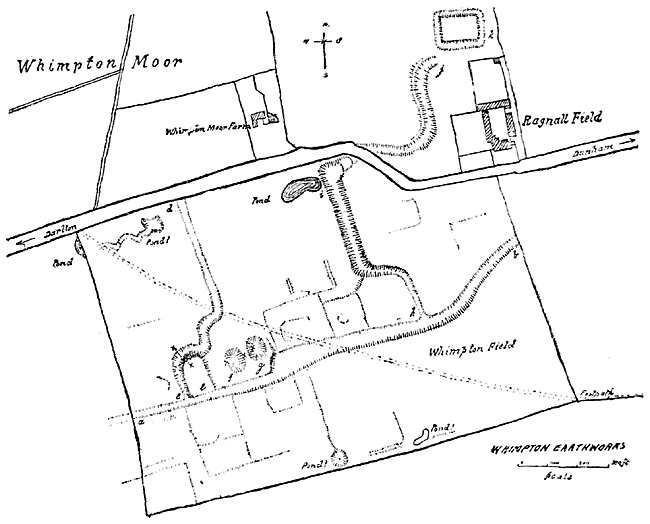
Whimpton earthworks.
The well defined roadway a b extends the whole length of the field from west to east, following the ridge of the hill for most of its course. Its width varies considerably, as can be seen by reference to the accompanying plan, and there is evidence of its continuation in a field to the west, but no traces are to be found in the cultivated field on the east.
The field to the south of this road-way bears distinct evidence of past cultivation, which, however, is entirely absent to the north. Two road-ways leading from the one already described, take their course down the hillside. The one, c d, skirts the platform e on its western and northern sides and continues a tortuous course to the hedge bordering the highway. The other, commencing at h, describes a winding and deep course as far as the pond i, where, turning to the east, it has evidently been cut through by the later highway, for its well-marked continuation is to be found in a field close to the farm-house. It terminates at j, and in close proximity to the rectangular and moated enclosure k, which probably represents a late manorial site of the moated homestead type.
The raised platform, e, is 120 feet in length and 70 feet in width at its southern end. Its northern face is steeply scarped, and rises some six feet above the roadway. Across it at this point a trench was cut into the platform, but no evidence of occupation was found.1
Scattered about the field, both north and south of the road-way a b, but mainly abutting on to it, are a number of enclosures and ridges.
The question which arises, is how far can we determine the date and origin of these earthworks. Reasoning by a process of exclusion, we may feel quite sure that they bear no resemblance to any early or Celtic work, still less is there evidence of Roman occupation.
On the other hand the positive characteristics of these works are such as to warrant the conclusion that they represent an ancient village site, and that this village was the Wimentun of Domesday seems amply supported by the present-day names of Whimpton Field, Whimpton Moor, and Whimpton House, identified with this locality.
Excavations were made on the borders of two shallow depressions, marked f and g. At a depth of nine inches, in every case, an artificial layer of broken stone, boulders, and pebbles was found. There was no evidence of mortaring. The present limited extent of the exploration does not permit of any expression of opinion concerning the date or use of this layer, which at one point was laid bare over an area of five square feet. Control excavations in other parts of the field gave no such result.
Historically, the first mention of Wimentun occurs in Domesday, where it figures as one of the four berewicks of the King's Manor of Duneham. "The berewick," Professor Maitland says—
("Domesday and Beyond," pp. 114-115.) "Seems primarily to signify a wick or village in which barley is grown; but like the 'barton' and the 'grange' of later days, it seems often to be a detached portion of a manor which is in part dependent on, and yet in part independent of the main body. Probably at the berewick the lord has some demesne land and some farm-buildings, a barn or the like and the villeins of the berewick are but seldom called upon to leave its limits; but the lord has no hall there, he does not consume its produce upon the spot, and yet for some important purposes a berewick is a part of the manor."
It is thus evident that the berewick did not enjoy the corporate life of the typical village community, and this gives us the clue to its occasional decay and disappearance.
Wimentun existed long after Domesday, and we find various references to it in the Pipe Rolls. In 15 Henry II., amongst the fines, we come across Roger Mercator de Wimentun 40s. In 4 Edward I., we read of Roger fil de William de Wimpton, and Thoroton, quoting records, temp. Edward III., speaks of the jurisdiction of the View of Frankpledge claimed by the Prebendary of Dunham of his tenants in Wymton.
The Rev. Howard Chadwick, of Dunham, has called our attention to a reference in the "Registrum Album" of the Chapter of Southwell. It is a decree, dated 1414 (2 Henry V.), by the Commissaries of Southwell, Richard, Andrew, and William Lambley, in a cause between the inhabitants of Dunham and Richard Allerston, Vicar there : wherein it is decreed, "that there shall be an able chaplain provided dwelling within the town of Dunham and Wimpton, and the inhabitants of the same to be restored to their former situation at the expense of the Vicar aforesaid."
A recovery of land in the Court of Dunham, 14 Henry VI., mentions appurtenances in Dunham, Ragenhill, and Wympton.
The latest mention we have seen is in an Inquisitio post mortem on the properties of Robert Nevyll, 20 Henry VIII. ("Thoroton Society Record Series," vol. iii., p. 182), and this record is doubly interesting as being the only occasion on which we have found a reference to Swarnesterne—here called Swaynstorn—the other lost berewick of the manor of Duneham.
But at this date there is no doubt that both Wympton and Swarnesterne were little more than field names, and that as inhabited sites they had ceased to exist.
Thoroton, writing 150 years later, speaking of these two berewicks, says, "Wymentun and Swarnesterne are now totally lost except the remembrance of some closes of Wymton or Swensterne still continue," and Cox, in his "Magna Britannia," published about 1730, carries on the tradition when he writes "the remembrance of it (Wimentun) is kept up by some closes called Wympton Closes."
With regard to the origin of the name Wimentun, we can only conjecture. Undoubtedly it is Saxon, and possibly comes from the same source as Wymeswold, in Leicestershire, Wymington, in Bedfordshire (spelt Wimentun and Wimtun in the Pipe Rolls), and other similar place names. The suggestion that they might have been the manors or estates of Wimund or Wigmund, a powerful Saxon thane, who, in the gth century, married the daughter of the King of Mercia, we leave unanswered.
Our thanks are due to Mr. J. T. Drewery, of Ragnall Hall, for having given us permission to make the excavations, which, we hope, may be continued at a future date.
(1) The sites of exploration are located on the accompanying plan by the letter X.