Autumn Excursion.
ON Tuesday, the 8th September, the Society made a half-day excursion to the villages of Car-Colston and Screveton. The party numbered about forty, including Mr. James Bell, Mr. G. G. Bonser, Mr. T. M. Blagg and Miss Blagg, Mr. J. Potter Briscoe, Mr. George Fellows, Mr. Harry Gill, Mr. J. T. Godfrey, Mr. James Granger, Mr. Everard L. Guilford and Miss Guilford, Mr. G. Hore, Mr. F. Pickerill, Major G. C. Robertson, Mr. John Thorpe, Mr. J. C. Warren and Miss Warren, Mr. T. C. Smith-Woolley, Miss Ashwell, the Revs. A. Du Boulay Hill, W. Laycock, A. H. Sutherland, and J. Standish. The brakes left Nottingham at 1.15 p.m., starting with the party from Victoria Station.
On arriving on the Fosse Road, at the site of Margidunum, situated a little to the north of the turn for Newton village, a stop was made for the purpose of inspection. No paper was read here on the occasion of the visit, but since that date the Rev. J. Standish has been over the site, and also made the following notes.
Margidunum
By The Rev. J. Standish.
![Water pipe found at Margidunum. [This is actually a hypocaust flue tile [know as a 'tubulus']](../../../../images/eastbridgford/tts1908/margidunumheatingblock1908.jpg)
Water pipe found at Margidunum. [This is actually a hypocaust flue tile known as a 'tubulus']
Speaking of this site, which he calls Ad Pontem, Stukeley in his Itinerary writes as follows: “The Roman station upon the Foss I found to be called Boroughfleld, west of the road: here a spring arises under the hedge, called Oldwork spring, very quick, running over a fine gravel; the only one hereabouts that falls eastward, not directly into the neighbouring Trent, toward Newton. Hereabouts I saw the Roman foundations of walls, and floors of houses, composed after the manner before spoken, of stones set edgewise in clay, and liquid mortar run upon them: there are likewise short oaken posts or piles at proper intervals, some whereof I pulled up with my own hands. Dr. Batteley tells us of oak very firm, found at Reculver, under the Roman cisterns: the earth all round looks very black: they told us that frequently the stones were laid upon a bed of pease-straw and rush-rope or twisted hay, which remained very perfect. Houses stood all along upon the Foss, whose foundations have been dug up, and carried to the neighbouring villages. They told us too of a most famous pavement near the Foss way: close by, in a pasture, Castle-hill close, has been a great building, which they say was carried all to Newark. John Green of Bridgeford, aged 80, told me that he has taken up large foundations there, much ancient coin, and small earthen pipes for water: his father aged near 100, took up many pipes fourscore yards off the castle, and much fine free-stone : some well cut and carved: there have been found many urns, pots, and Roman bricks; but the people preserved none of them; and some that had coins would by no means let us see them, for fear we were come from the lord of the manor.”1
Stukeley visited this Roman station Sep. 7, 1722, and made a sketch thereof, from an eminence a mile to the south. The first edition of his book was published in 1724.
In his “History of Newark,” Mr. Cornelius Brown notes that Esdaile in his "History of Bingham” records the discovery of the base of an octagonal tower in Castle Hill field. The family of the late Rector of Bingham, Canon Miles, found between 1845 and 1883 vast quantities of Roman remains in the fields named Old Wark, Camberlins (Cumberlands), and Newton Springs; and, on the south-west side of Newton Springs, enormous quantities of staghorns and boars’ tusks and every kind of animal bones were found, besides immense quantities of broken pots; as if this part had been a refuse ground of the camp.
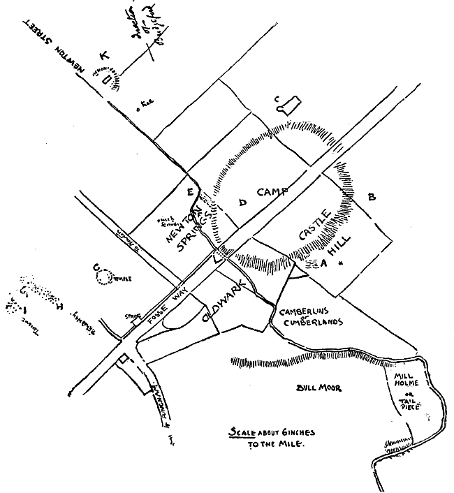
(A) Skeletons found here; feet to east, sixty years ago.
(B) Pot of coins said to have been found here.
(C) Pond at west corner, a part of bank sunk forty years ago.
(D) Arch exposed here, and other masonry, fifty years ago.
(E) Hypocaust tile found. Now in Nottingham Museum, circa 1870.
(F) Great quantities of deerhorns, sawn, found here.
(G) Supposed site of round temple. Pot of coins said to have been found here eighty years ago.
(H) Gravel road, exposed about twenty years ago; Roman key.
(I) Quantities of tesserae, ditto, about one-and-a-half inch square.
(J) I imagine a mill and waterwheel stood here, probably that called Sir John Lowdham’s, but whether as early as Roman times is another question. An old woman said she could remember masonry above ground in Castle Hill Field. Rev. Rt. Lowe, Rector of Bingham, lowered the high ground in Castle Hill Field. Quantities of stone were taken away to Flintham Hall about 1820.
(K) Supposed amphitheatre.
(L) In the old Bingham terrier mention is made of a bridge on the Foss. I am inclined to think there was a Roman bridge here crossing the marsh.
“Reasons for thinking this Station AD PONTEM:—
The name BRIDGEFORD proves it; because there is no evidence of a bridge since the Conquest, as special mention is made of the Ferry at Gunthorpe in a grant from the Priory of Shelford to that of Thurgarton, which deed seems to have been about the 13th century. Yet the very name BRIDGEFORD implies there was a bridge before there was a ford, or at any rate there was a bridge some time or other. So it must have been the Roman bridge, a bridge of boats, communicating with the county on the other side of the Trent. At right angles to the Fosse road an ancient street runs down to the Trent, starting from this camp and going down a very steep cutting to the Trent side. This is called Newton Street, and it was used as a packhorse way till the end of the last century. In the ordnance map an old road is shewn on the opposite bank of the Trent where the Roman way goes down to the water. Here we have then a bridge over the Trent— and a made road (on the map will be seen near E, the pitched causeway, exposed about twenty years ago) running directly to the Trent, and to the place on the Trent most suitable for a bridge. Surely then, this camp is AD PONTEM, TO THE BRIDGE, the camp on the great road, where you turn off to cross the Trent. The Newton Street is guarded at its descent to the Trent by a Roman fort called PANCAKE HILL. Some people think East Bridgeford was Margidunum and this camp Ad Pontem. The name Margidunum, I imagine has nothing to do with Marl, but is Margo-dunum—the marge or verge of the hill, that being the common meaning of margo—the margin of a river—and it exactly suits the situation, East Bridgeford being essentially a village on the verge of the long range of hill. Throsby mentions (Throsby’s Thoroton’s History Notts., 149) an earthen pot full of coins being found at Castle Hill. Then my mother was told of a pot of coins being found in the grass field near the site of the round temple, which is said to be traceable in very dry weather. But I cannot make out that any quantity of Roman remains have been found at East Bridgeford. When any have been found at Castle Hill, which is a mile and a half from Bast Bridgeford, they have been described as found at East Bridgeford, as that is the nearest village and most of the Roman camp is in East Bridgeford parish and part of it is glebe of that place. There were probably outlying suburbs and villas which extended the Roman settlement almost to the banks of the Trent. North and north-west of the camp, parallel with Newton Street, the fields are mostly called Barrow or Borough, and in an old Bingham terrier there is much mention of places called Borough, as Littleborough, Netherborough, Overborough, all of which places seem to have been in the neighbourhood of Newton and Oldwarke. At K, in the map, is a curious excavation in the side of the rising ground, which, I am almost sure, is an amphitheatre. It is just close to the street and is similar in size to that at Silchester, but not so deep. At C, is a very curious pond on the top of rising ground. At the west corner of this pond the bank sunk, about forty years ago, some seven or eight feet, altering the shape of the pond from a parallelogram to the figure shewn at C. There was every appearance of some subterranean cavity having fallen in. At D, masonry and an arch were exposed, in digging for stones, some fifty years ago, an eye-witness told me. At F, while draining or digging for stones, some twenty years ago, great quantities of old stag horns, boars, tusks, and old shoe leather were found, and some of these are now in the Castle Museum. At E, was found the hypocaust now in the museum. At H, my mother can remember a gravel causeway being exposed some thirty years ago. I have indicated its apparent direction. At I, at the same time, quantities of tesserae, as if for the pavement of a villa. At A, were found, about 1820, numbers of skeletons, feet to the east, showing Christian burial. The field called Camberlins (or Cumberlands in some maps) seems to me to preserve the name Camp, and the three fields Oldwarke contrast with Newark and the neighbouring Newton.Frank Miles, 1884.
(1) Itinerarium Curiosum, pp. 105, 106. Second Edition, 1776.