It was with the hope of discovering, among other things, something of the ground plan, that excavation was attempted in the summer of 1933. Throughout, the work was handicapped by the necessity to fill in again each day. Although digging was carried out on two days only the party was numerous. The two places at which excavation was undertaken are marked “A” and “B” on the accompanying plan. On the first day digging was confined to the north-east corner, “A” only, but on the second day one party worked at “A” while a second worked at the north-west corner “B.” At each of these corners there are suggestions on the existing wall (almost 5 feet thick) of angle towers, and the first aim was to see whether angle towers had been a feature of Greasley or not. The first day’s digging, i.e., at “A,” produced no sign of foundations of any tower, even at a depth of nearly 6 feet. It seemed that the wall went straight on, an idea which had to be abandoned after the second day’s digging. At a depth of 3 feet 6 inches and below, pieces of broken pottery were found along with small pieces of charcoal and coal, part of an 18th-century clay pipe, and small pieces of bone. Most of the pottery was afterwards declared by the Curator of the Nottingham Castle Museum to be of 17th-century date. Much of it was glazed inside but not outside, a characteristic of pottery used in the kitchen.
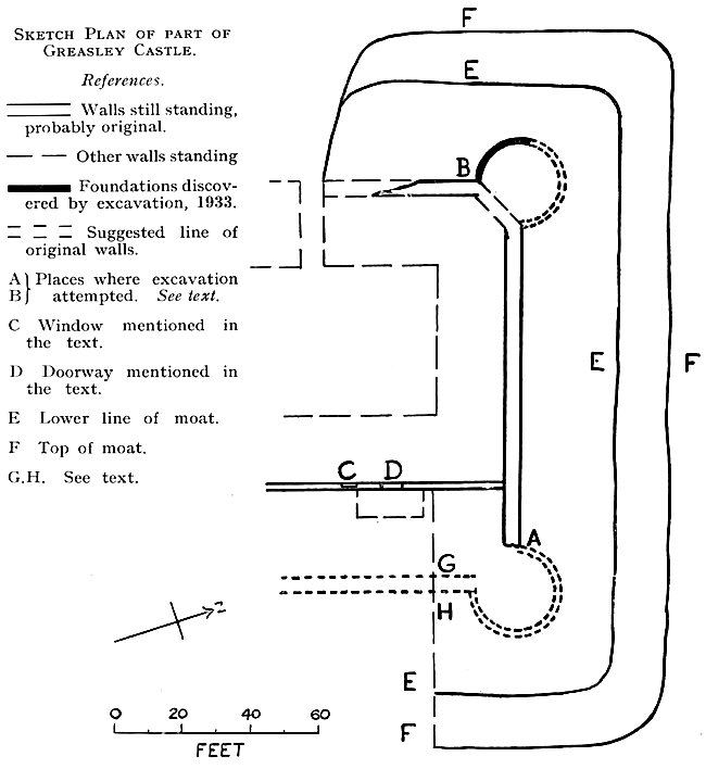
The work on the second day produced more satisfactory results. The party working at “B” soon met with success and, before filling in had to be considered, the base of a round tower some 20 feet or more in diameter had been uncovered to about one third of its circumference. The other end “A” again failed to give positive results. Although two trenches were made at “A” in an attempt to find a continuation of the existing wall, or the base of a tower, neither was found. But in spite of this it still seems probable that a tower did originally exist at this corner, for the projections on the wall at this end are very similar to those at the north-west corner where the existence of a tower was definitely established. The plan will show that if a tower existed at “A” the same size as that discovered at “B,” the distance between its outer edge and the top of the moat, would be the same as the distance from the outer edge of the north-west tower “B” and the top of the moat.
In the 14th century angle towers were generally built square, reverting to the form which has been superseded for military purposes by the round tower. The existence of a round tower in a fortified house of the date of Greasley is somewhat unusual, but not very surprising, as the shape did not matter much. In manor houses no attempt was made at the scientific flanking of a curtain wall such as had been developed in castles of the 13th century.1
Is it possible from the evidence available to form any idea of the ground plan of Greasley? It must be stated at once that it is not possible to be definite. The best that can be done is to put forward a theory which seems to be justified by the information we have. In the first place it seems reasonable to suppose that Greasley was square or rectangular with angle towers. But this is not saying much, and no description of a medieval manor house is complete without reference to the hall, the kitchen and buttery, and to the solar and other family apartments. The hall at this period and for centuries afterwards was easily the most important room in the house. It has been said that the hall was not so much the heart of the house but the house itself.2 The tendency which has persisted to this day, to call the principal house of the parish “the hall” is not mere chance. At one end of the hall was the solar to which the lord might retire when he desired privacy; at the other end was the kitchen department, the headquarters of the servants. The entrance to the hall was placed at the servants' end, whereas the “high table” at which the lord and lady sat, occupied the upper or solar end, away from the draughty entrance. The discovery of the position of the hall, the solar and the kitchen at Greasley would be an important step in solving the problem of its ground plan. How important may be seen from the statement made by J. A. Gotch that “the main idea of entering the hall at its lower end, of the kitchens being at this end and the solar or family rooms at the other, is so universal as to furnish a clue to the unravelling of the mysteries of many a complicated ruin.”3 Will this prove to be true in the case of Greasley?
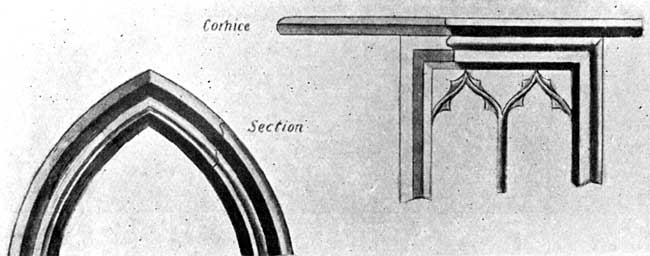
Portions of old windows in ruins of Greasley Castle. Taken from Baron Von Hube's Book GRISELEIA.
In the wall at the back of what is now a stable are a door and a 14th-century square-headed window both built up (marked D and C respectively on the plan).4 It is not unreasonable to suggest that this door might have been the entrance to the hall from the courtyard. The finding of coal and charcoal, small bones and pottery intended for kitchen use at position “A” seems to point to the existence of the kitchens at this end. If the door “D” were the entrance to the hall its position would be in accordance with the general practice mentioned above. The window “C” looking into the courtyard would not present to an enemy an easy means of entering the house. If this suggestion is correct we might expect to find a hall about 33 feet wide, and of an unknown length. The hall of Oakham Castle, said to be the finest example in England of an early hall, is 65 feet long by 43 feet wide.5 The hall at Stokesay Castle (1240-1290) is 52 feet by 31 feet,6 that at Haddon 43 feet by 28 feet, 4 and that at South Wingfield Manor 71 feet 7 inches by 36 feet 5 inches.7
Against this theory of the position of the hall it may be urged that the position of the window should be further to the south than “C,” for it is likely that the only use of the window would be to illuminate the dais. On the other hand, as the window seems to be a little later than the door, it is possible that an oriel window existed somewhere further along that wall and that the window “C” is an inserted window. It is at least a theory that might be investigated.8
Mention has already been made of the description given in the Victoria County History of Nottinghamshire of the earthworks surrounding Greasley Castle, and forming apparently two courts. It would be interesting to know whether these ramparts were surmounted by a wooden stockade or a stone wall. There is no evidence to suggest a stone wall, although in places the ramparts have been cut through to make roads, or for other purposes.
It is unfortunate that no prints or plans have come to us to solve the problems which Greasley presents, but further excavation would probably be worth while. The excavation attempted in 1933 handicapped as it was by the necessity to fill in again at the end of each day's work, was never intended to be more than a trial excavation. The work at Greasley and the writing of this article will be considered worth while if interest in Greasley Castle is increased, and if the house is, as a result considered with Haddon, South Wingfield and Wollaton, in the story of the growth of the larger English house. It would be a good thing if a society or group of antiquarians, more expert in this branch of local history, and with greater resources than the writer of this article, would continue the work begun, and give to the county a fuller and more satisfactory account of this interesting medieval fortified manor house. It may be of use to suggest that in the event of further excavation a trench from G to H (see plan) might reveal the existence of the foundations of the outer wall, and help to solve the problem of the north-east angle tower. In addition a more thorough examination of the north-west tower would probably give interesting results, and a trench cut across the moat might lead to the discovery of its original depth.
(1) Professor A. Hamilton Thompson.
(2) The Growth of the English House,
J. A. Gotch, p. 24.
(3) The Growth of the English House, J. A. Gotch, p. 27.
(4) In Baron von Hube’s Griseleia between pp. 92-93 drawings of these
are reproduced. They are both called windows but there seems to be little doubt
that one is a door.
(5) Gotch, p. 27.
(6) Gotch, p. 37.
(7) Gotch, p. 70.
(8) For the valuable criticism of the theory of the position of the
hall contained in this paragraph I am indebted to Mr. J. Holland Walker.