
< Previous | Contents | Next >
6. Rivers—(ii) The Tributaries of the Trent.
Within the county the Trent receives many more tributaries on its left than on its right bank.
A glance at the map shows that those on the left may be classified into long streams which rise on the Western Hills, and short ones which rise on the Central Hills. To the former belong the Erewash, the Leen, the Dover Beck, and the Idle with its tributaries the Rainworth Water, Maun, Meden, Poulter, and Ryton.
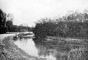
The Meden at Budby (typical Bunter Sandstone stream).
The last two rise outside the county; the remainder on either side of a short watershed which trends from west to east through the Robin Hood’s Hills. From this a minor water-parting runs southwards and separates the basins of the Erewash and the Leen. The latter has on its left side a solitary tributary, the Daybrook, which rises on the Central Hills.
A long strip of the county is characterised by the fact that it gives rise to very few streams. It is narrowest at Nottingham. Thence it widens northwards until it occupies nearly the whole of the north-west quarter of the county. The streams which cross it exhibit a general absence of tributaries.
The longest watershed is one which passes along the crests of the Central Hills. A few small streams flow westwards from this line and fall into the Leen, Maun, and Idle. Many more flow eastward. In the upper parts of their courses they are little torrents and have made for themselves waterfalls and gorges. The latter are sometimes 20 to 30 feet deep and are known as “dumbles.” They lie at the bottoms of broad open valleys and are hidden from view by overhanging trees.
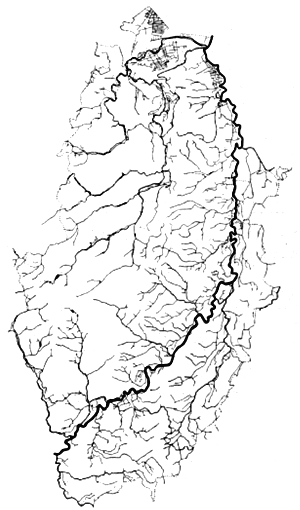
The River-Systems of Nottinghamshire (showing every tributary-stream and dyke, and the marked contrast between the Sandstone country on the west and the Clay country on the east).
To the right of the Trent the main water-parting runs north and south along the Wolds. From Newark to the point where this meets the Trent there are no tributaries. All the drainage from the area east of the divide is collected by the Smite and the lower reaches of the Devon. Both these streams rise in Leicestershire, but the former runs for the greater part of its length through Nottinghamshire. From the other side of the Wolds the streams at first flow westward. One continues in this direction and falls into the Soar, the remainder turn sharply to the north and enter the Trent.
There are no natural lakes in the county. One known as the Whitewater formerly existed just south of Styrrup, but it was drained and now forms Whitewater Common. Several artificial lakes exist on the courses of the Maun, Poulter, and Rainworth Water.