< Previous | Contents | Next >
The domestic buildings
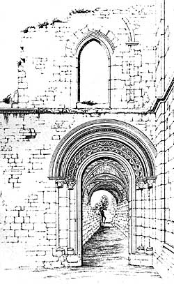
Entrance to Cloisters (c. 1875).
The sum total of all lands belonging to Worksop Priory, when these were bestowed upon Francis, earl of Shrewsbury, amounted to 2,333 acres, 2 roods, and 19 perches. To him also were given the monastic buildings. From this survey it appears that a considerable portion of these last was then standing, but in a ruinous condition; in it the Priory is thus described, "Imprimis, an auncient house, wh in tymes past was a Priory, being much decayed, adjoyning unto Worksop church." There is mention made also of a kilnhouse, granary, and brewhouse, situated near the mill in Priory Foulds, between the other priory lands on the east, and Pond Yards on the west. A small portion of the Priory has survived the lapse of years since the above-named date, consisting chiefly of a wall pierced with a fine doorway, marked [o] on the Plan, adjoining the north-east angle of the north-west tower of the church, and of the same date as that tower.
This doorway opened into a passage [p], having a groined roof, now forming the vestry of the church.
There are also in the said wall two small round-headed windows, and a third that has been converted into a doorway, in addition to another original round-headed one.
Until lately a portion of an upper storey to this building remained, in which was one plain pointed window and indications of others. The eastern face of this wall [q], from its traces of arches and its brackets, shows that it was connected with a groined roof, and the northern one of the passage above-mentioned [p], that that roof was supported by a central row of pillars. These facts, in addition to the testimony of foundations of walls that have been found, point to the former existence of a building here 85 feet long and 25 feet wide; its height also was declared to be equal to that of the clerestory of the church, by a gable of the same, containing a window that existed until the recent alterations. This feature (marked L) was probably the dormitory of the Priory, built above on undercroft.
The passage [p] was the vestibule, or approach to the cloister [M], which was continued as far as the transept, as indicated by the windowless north wall of the church and the brackets in the same, until it was rebuilt. There is no positive evidence as to where the other three sides of the cloister ran, excepting the discovery of foundations that certainly favour the lines given in the Plan, which thus form an exact square, having the still existing Priory well [N] in its centre. On the north side of the cloister we might expect to find the refectory, in accordance with the usual monastic arrangement; and that such was the case at Worksop can scarcely be doubted, from the evidence of a discovery made about thirty years ago in excavating for the foundations of the Girls’ National School. Remains of an ancient building were then disclosed, consisting of very large carefully squared stones, laid upon oaken piles; and also a portion of a stone pavement. This building is marked [O] on the Plan; and from the discovery of many animals’ bones turned up around it, as well as of boars’ tusks and portions of deer’s horns, we may fairly assume that there was the refectory, with the kitchen adjoining it.
On the eastern side of the cloister we naturally look for the chapter-house; and the discovery of foundations, as indicated at [P], leads us at least to suggest that such was its position and size.
The usual position of the Prior’s lodgings would incline us to search for these at the north-eastern angle of the cloister, but no foundations have been disclosed there; sometimes, however, this building was at the opposite angle of the cloister, as at Bridlington; and, as at Worksop, remains of ancient walls existed until lately at [Q] including a lofty well designed chimney springing from a moulded bracket; there, we may at least suggest, were the Prior’s Lodgings, immediately communicating with the cloister entrance. At some distance to the east of the church was the Priory infirmary, a detached building in a field formerly called the "Fermery Yards," where now is the New Cemetery: and here, not long since, was found a small floor of stones having a raised margin around it, which probably had formed the hearth of the Infirmary, as the stones were strongly marked with fire. Beyond this is a deep depression in the ground, running north and south, which is perhaps a portion of the "magnum fossatum" of Richard Lovetot’s charter, beyond which he gave a mill to the Priory, and a tenement: "totum videlicet situm villce de Wirksop, iuxta ecclesiam, sicut per magnum fossatum clauditur usque ad pratum de Bersebrigga, et extra fossatum sedem molendini cum mansura und." A mill and tenement still existed at Bracebrige in 1636, which may be those here alluded to, near which was "Jesus House," mentioned in a survey of that date as being "moated about," and standing in part up to this time within the remains of its moated enclosure, a little to the south-east of Bracebridge. The road leading from the Priory gateway to Jesus House and Bracebridge was formerly called "Long-wall way," but now "Cheapside." Its first designation was probably derived from one of the large "closure waulles" of the Priory, spoken of by Leland. To what use "Jesus House" was applied is not known.’
South-west of the Priory gate-house, in a close called Marecroft, was the Priory-barn, whose site was marked until lately by the remains of an old building; south of this were other Priory lands, respectively called Laith Fields, Arnall Park, and Arnall Park Wood. West of the Priory, and between it and the mill, was a small close, termed Priory Fould, adjoining a field called Great Pond Yard, probably deriving its name from the vivarium, or fish-pond, mentioned in the Priory charters as. being near the church; beyond this was another field called Buslings (Pratum Buslini).
North of the Priory was a small meadow called Little Pond Yards, and beyond it another, termed Prior’s Well Meadow; the road adjoining is also still called Prior-well-way, because it led to a fine spring of water, gushing into a trough on its western side, from a source in a field formerly called Wellhouse Yards, which spring is now diverted.
From the above-named survey it appears that the tenants of the Priory lands were, in addition to their money payments, required to render certain capons and ling to their landlords; on the death of a tenant a small payment was also demanded, "nomine Heriot," as it is termed.
The only other object of interest in connection with the Priory that we need allude to is a fine groined bridge, that stood about thirty yards to the north of the present one, over the mill-race, but which was needlessly destroyed by an officious surveyor of the highways some years ago. True it was of no use, as the stream it once spanned had been previously directed into a new channel; but as it was no impediment to the road, and was an interesting relic of the past, its destruction was a needless act of vandalism which is to be regretted.