The Old Streets of Nottingham.
No. III.
By James Granger.
IN the latter half of my second paper I directed attention to some thoroughfares in the vicinity of St. Mary's Church, and will now refer to another matter relating to that locality. As regards the old town, the ground near the church is probably as high or higher than most of the other parts near. I have a full recollection of seeing, in St. Mary's Gate, sixty years ago, an extra large piece of granite, which was used when paving the middle of the road, and probably measured twenty inches by ten. After enquiries I was informed that this stone was to mark the spot as being on a level with the top of the Castle rock. It was, I believe, from forty to fifty yards nearer to Pilcher Gate than the upper and north side of the churchyard, and possibly of the altitude stated; though I cannot vouch for this.
I desire to correct an inaccuracy which passed unobserved in the latter part of my previous paper (No. II.), when referring to the waterworks near the Leen. There were two places in that locality at different periods, from which water was supplied to the town, the one mentioned commencing in 1827 but matters of an earlier date were being referred to, and therefore it should have been said that the "old waterworks" (1696) were near the Leen, "at the lower end of Finkhill Street;" still, as a fact, the more modern structure going back full sixty years, was termed " the old waterworks," to distinguish it from the supply afterwards obtained near the Trent Bridge, and still later from various other sources.
By 1827 an additional supply was necessary, and one was acquired near Scotholm, Basford, where a small reservoir was formed. From thence by iron pipes the water was brought down the valley of the Leen ; and for much of the latter part on its bank, to Brewhouse Yard, and then forced up to a small reservoir, which now forms part of the infirmary ground. Before the formation of the Lenton (now Castle) Boulevard, the upper side and joints of the iron waterpipes could be seen in many places, when walking that way to Lenton; for with some their depth in the ground was barely sufficient to cover them. I thought that the natural fall of the valley was probably the only cause for the water running to Nottingham. The internal diameter of the pipes I considered did not exceed nine inches, though said to be more.
The next place for consideration will be St. Peter's Gate, which is one of our oldest thoroughfares, and in times long passed was occasionally termed "lane," but its description proved that St. Peter's Gate was really referred to. See Records, vol. i., page 367 (after 1284), also p. 374, 1305, &c. Until about 1870, in this roadway especially, but also in Bridlesmith Gate, &c., some very old and interesting houses were to be found. In his " Nottingham Castle," when alluding to the year 1870, Mr. Hine says, "Peter Gate widened. Some interesting timber constructions, and enriched panel work in some were unfortunately demolished."
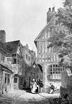
THE UPPER PART OF ST. PETER'S GATE, 1870, looking eastward, with the fine old oak framed house, at the north-east corner of St. Peter's Church Yard.
Happily I am, however, enabled to make some amends, with an excellent illustration of various old structures in that immediate locality, together with a view of its narrow upper and eastern end, where vehicles could not pass. This part was first enlarged, and the addition obtained mainly from the southern side. In 1884 numerous remains were removed from the churchyard to the Church Cemetery, and the additional ground required for the street taken from the graveyard. The rare wood-framed house exhibited as being close to the corner of the churchyard was unfortunately but necessarily demolished, its site being required for the roadway. Of its kind it was probably the finest of any in or near Nottingham, and a constant object of admiration. The old street was considerably wider at the lower than at the upper end.
I propose now to comment upon the two roads or ways, one at the north and the other at the south of St. Mary's graveyard, and beginning with the former, which is termed Kaye's Walk. This comparatively is a modern name, and unknown to Glover, who published his Directory of Nottingham, in 1844, but it is in that of Lascelles and Hagar's dated 1848, where I find it as "Kaye's Walk, St. Mary's gate." Approximately, therefore, it dates back about sixty years. I have, however, some recollection of its being previously entitled St. Mary's Church Walk or Yard, which would agree with the names of similar passages near St. Peter's and St. Nicholas's Church.
I am induced to refer more carefully to this footway to disabuse the minds of some who have inaccurate ideas respecting it, and I am fortunately enabled to give an extract from one of Mr. William Stretton's numerous manuscript notebooks, some of which are now in the possession of Mr. John T. Godfrey. As Mr. Stretton was alive at the time referred to, and residing in or near Nottingham, his evidence is conclusive. He says:—"St. Mary's Churchyard was inclosed by an iron pallisading in July, 1806; a road was taken off the north side, which was before open to the churchyard—the north and west walls then built—the east wall was built in 1804, and the south wall with the pallisading thereon in the year"--(blank). This will shortly be shown to have been 1792.
It is here proved that the footway to the north of St. Mary's Church was severed from the graveyard last century, and in 1806. Its present title therefore is not an old one, and no doubt others besides myself still remember the time of its adoption. It is derived from the Very Rev. Sir Richard Kaye, Bart., LL.D.; Rector of Kirkby-in-Ashfield, Notts.; Rector of Marylebone, Middlesex; Prebendary of Southwell; Archdeacon of Nottingham; and Prebendary and Dean of Lincoln; who died December 25, 1809, and is buried at Lincoln.
In the Borough Records, vol. 3, p. 476 (1487) the editor says, "St. Mary's Churchyard, lane by—probably Kaye's Walk."
This is incorrect as may be proved from the remarks just made. There are also references on pages 259-60, to lanes and gates, which imply roads for vehicles 319 years previously, and cause me fear that the editor was not so fully provided with the various old histories, plans, illustrations and documents relating to old times in Nottingham, as it was proper he should have been, when bringing out an official work of such great importance as the Borough Records.
On various occasions, by his references, we have evidence that he no doubt had Deering's and Thoroton's Histories at command, and if in connection with this matter he had fortunately once more referred to the plan of Nottingham in Deering he would have perceived that in 1744, except it might be by stiles and a footpath, there was no road whatever across the north side of the old graveyard. This was still the case about fifty-six years later, as shown on the large and unique plan of the town in my possession, and formerly mentioned as dating from 1800.
At different periods and places in the Borough Records, it is proved that a few centuries back there were stiles to each of the three old churchyards, and respecting St. Mary's Church, it will be found in vol. iv., that on pages 130, 154, and 316, there is an allusion to one on each occasion. Regarding the latter page it relates to what occurred in 1614. In paper No. II. I refer to a large and very fine old engraving of Nottingham from the east, dating about 1690, by I. Kip, and on it the stile just mentioned, is plainly exhibited. It is at the east, or Stoney Street end of the footpath across the graveyard, and close to its northern boundary. These explanations will, I consider, enable all to comprehend how and when the various changes were made in relation to the old footpath, and the forming of the passage now termed Kaye's Walk.
The ground next adjoining the old graveyard and footpath (to the north) and reaching from Stoney Street to St. Mary's Gate, was owned by two persons, and with the buildings thereon was in two occupations. The one next to Stoney Street reached backwards and toward St. Mary Gate, about three-fifths of the space, and the house in St. Mary Gate occupied the remaining portion, or about two-fifths. Many persons still alive will, with myself, remember them as they were before demolition ; and each in its way was worthy of notice.
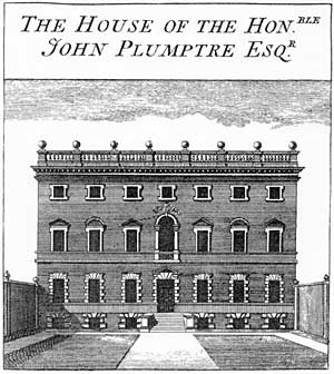
Plumtre House as depicted in Deering's History of Nottingham (1751).
Deering, next to page 8, introduces an excellent engraving of the eastern one, as representing an old town residence entitled Plumptre House. It was, no doubt, one of the finest to be found near, and from its elevated position, and being rather higher than most other buildings, it was a noticeable object from the east and south of the town. This was one of the last and most elegant of the old Nottingham mansions, and belonged to the Plumptres. I have seen it stated a time or two that it was built in 1707, and various circumstances in a large degree testify to the accuracy of this statement. The family had an earlier residence in Nottingham on the site of which the late Dr. Ransom's house and others were erected at the upper end of Low Pavement, next to Drury Hill, the ground reaching nearly through to Broad Marsh.
John Plumptre, who was the last of that family to occupy Plumptre House, died 1791, at his London residence, Jermyn Street, Westminster, in his 80th year. Alderman Wilson lived in the house many years, and also others at intervals. There was—for a town house— a considerable quantity of land attached to it, even when deprived of the vista, and on February 21, 1853, the Date Book informs us that "Plumptre House and grounds" were "sold by auction," and "knocked down to Mr. Alderman Birkin for £8410." Both sides of Broadway, as regards the new street and grounds, were included in this purchase.
On his plan of the town Deering shows that Plumptre House, looking eastward, had much the largest vista in Nottingham attached to it. Commencing from the opposite side of Stoney Street, and with a fine avenue of trees, it is shown as reaching to Bellar Gate. This was a number of years before Plumptre Street was formed; but the avenue occupied much the same position, and no doubt from the altitude of the house, the prospect would then be a fine one. At that time the nearest houses to the south, or right of the vista, were those on Short Hill.