The other house referred to in St. Mary Gate, and close to the west end of Kaye's Walk (when formed) was an old one, wood-framed, but of a good size; and respecting which I have found a few incidental references in the Borough Records, of two or three centuries since. In 1806, and probably some years earlier, it was occupied by Mr. William Trentham, sen., and he was living there until 1820, and probably a few years after. Some of these details were obtained from poll books, and some from the Date Book, where I consider it to be accurate. It usually is, I believe, but probably not in all points in this case.
On page 284 it informs us that on April 27, 1812, at 9.45 p.m., an attempt was made to murder Mr. William Trentham, sen., an extensive hosier of this town. He had been to a convivial meeting at a friend's house, and was returning home; had knocked at his house door, facing the churchyard, for admittance, and while waiting for it to be opened, two men stepped up to him from amongst the gravestones (? they must have got over the fence), and one of them instantly, without uttering a word, discharged at him the contents of a large horse pistol.
He was dangerously wounded, and at first, recovery was doubtful, but with care and attention he was ultimately restored to health. The Date Book says that his house door was " facing the churchyard," but on various occasions when voting both he and his son described their residence as being in St. Mary Gate; and a gentleman who years afterwards frequently visited at the old house, assured me positively that the entrance was in St. Mary Gate, and other circumstances point to this as doubtless being the fact.
Still another tragic event occurred as regards a resident in this house. It appears very probable that Mr. Trentham, upon leaving, was shortly succeeded in the tenancy by Mr. Daft Smith Churchill, who lost his life in the wreck of The Forfarshire steam vessel in 1837, when Grace Darling so nobly endeavoured to rescue the passengers and crew. In the Nottingham General Cemetery a large monument was erected by his fellow directors to commemorate his death. In this ancient house were various interesting old fixtures, and amongst them some antique and noted chimney pieces, one or more of which were removed afterwards to Pietermaritzburg, Natal, South Africa, by a son of Mr. Daft Smith Churchill, who had settled there.
The old house and premises were probably demolished nearly fifty years since, and warehouses erected on the site, the chief frontage now being to Kaye's Walk. During the excavations for the cellars and foundations, the workmen came upon a large tunnel, running northwards from the graveyard, and going for a distance under the ground belonging to the old house. It had no doubt been there for at least several centuries, though all knowledge of it had been lost. A few articles were found therein, proving its great age, but not of special interest. Afterwards, as soon as convenient, a strong wall was built across it, on which to rest the front of the warehouse in course of erection, and but few people saw or knew of the tunnel at the time. I received this information from Mr. Wallis, who owned the property at that period.
In my paper, No. II., I refer to the row of houses forming part of the southern boundary of St. Mary's graveyard, commencing from St. Mary Gate; these were pulled down in 1792, as stated. There was, however, at one time, as shown on Thoroton's plan, another house at the south-east angle of the churchyard, which also was pulled down, a number of years before the row referred to ; and from what Deering tells us it appears to have belonged to the Duke of Kingston, who allowed the corporation to remove it to obtain increased facilities for those going up Hollow Stone, by considerably widening the road-way at the top.
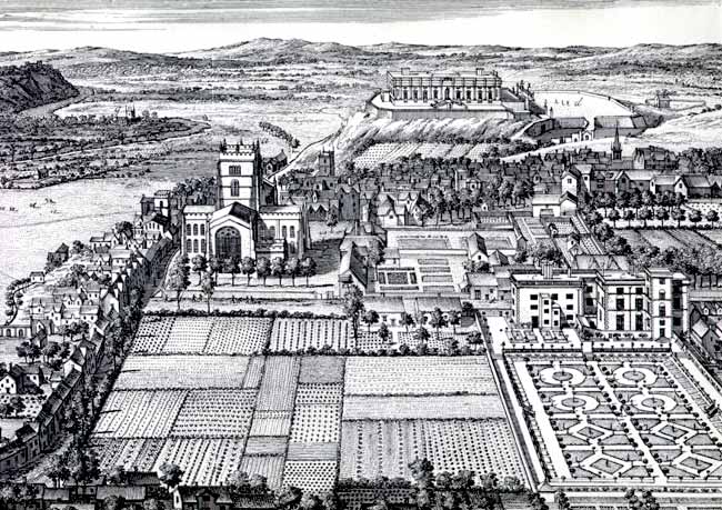
Jan Kip's "East Propect of Nottingham" (c.1707-8).
I have mentioned before that large, old, and fine eastern view of the town, by Kip, which is very rare, and proves that the north end of Stoney Street was practically level with the graveyard. Deering, on p. 4, tells us that the widening of Hollow Stone commenced in December, 1740, and though not directly mentioned, there can be little doubt, I consider, that the Stoney Street cliff was also cut away a few years previously, which with the removal of the house, at the angle, and a wider road, would then allow of vehicles getting round into that street on more level ground. After the alterations that end of the street is by Deering (see page 12) called "St. Mary's Hill;" but the name was not long or generally accepted.
Respecting the cliff which was once at the south end of Stoney Street, some doubt has been expressed in reference to what is stated in paper No. II., although its accuracy is vouched for by the rare old eastern view of Nottingham then alluded to, which dates back approximately to 1690, and would be contemporary with the cliff. Yet, strange to say, the explanation from the illustration is improperly ignored, and what is mentioned respecting it is treated as theory only, in place of hard fact.
Fortunately there is further, and undoubted proof of the thorough truthfulness of what is exhibited on the fine large eastern view as described, and which can be remembered by myself and many of my older fellow citizens. I am now referring to the period about 1852. At that time the rocky cliff to the north of Hollow Stone and at the lower part was probably twenty-five feet or more in height above the causeway, but lessened gradually as Stoney Street was approached, and at that corner it is considered (by persons remembering) to have been probably more than twelve feet high.
Commencing against Plumptre Street, there were several houses when going towards Hollow Stone, some having many steps to their front doors. The rocky cliff was continued round the corner from Hollow Stone to these houses. In Hollow Stone, and also in Stoney Street, the soil at the top was cleared away for a foot or more to the hard rock of the cliff, and a wall was then built upon it for its whole length. The rock visible on the east side of Stoney Street to its termination against the houses was incontrovertible proof that there had once been a cliff at the end of the street, and that it had been cut away. This, however, was of course many years before the erection of any warehouse on the north side of Hollow Stone.
I now desire to remark upon the roadway from St. Mary Gate in the west, to Short Hill in the east. For a number of years at the latter end of the 18th century, and also at the commencement of the nineteenth, it appears to have been entitled "St. Mary's Church Side," and that term is applied to it in Willoughby's rare little Directory of 1799. Blackner on page 71 (1815) places it amongst the "Names of the Principal Streets."
We still have St. Peter's Church Side, reaching from Church Gate to Albert Street, and before the latter street was formed, extending to the bottom of Hounds Gate, and in some degree comparable in that state with St. Mary's Church Side.
It must be nearly ninety years since the latter name was superseded by a return to the former and present title of "High Pavement," which, though spelt in various ways, has been attached to this street since the 14th century, and there appears to have been as little or less change in its name than with most old names.
Respecting this roadway, and possibly in a few other instances, some little changes may perhaps be occasionally observed in my remarks when compared with what has previously been said, yet further research necessitates some modification. During the last few years much additional information has been obtainable from my old and unique plan of Nottingham, together with a number of other matters of reference, plans, illustrations, manuscripts, &c., recently acquired. Accuracy, therefore, demanded that some preceding ideas and statements should be varied, for which I ask the reader's favourable consideration.
Some attention will now be given to Hollow Stone and Malin Hill, which are two old roadways leading into Nottingham, chiefly from the south and east, and appear to be first mentioned about the same period. In the Records (vol. i., page 433) Hollow Stone appears to be referred to in 1357, and on page 436 (1303), John Malyn is mentioned, and that from him the hill probably derived its name. According to the Records there can, I consider, be little doubt that for two or three centuries after the dates given, Malin Hill, as regards importance, ranked quite as high, if not higher, than Hollow Stone. In proof I will give an extract from the Records (vol. i., page 433) where, in reference to a document, it says:— "A.D. 1366, the Holoughstone, near Malynhill."
I am convinced from its environment, that as regards the acclivity, Malin Hill is much the same now as it was more than 500 years since, but respecting Hollow Stone, I have no doubt from the conformation of the ground near, and especially in the lower part, close to what is now termed Plumptre Square, that if in former times there was no cliff, the hill was so steep and rugged as to render it unadvisable to take some animals into the town that way. At various dates we may read of improvements being made to the road, of which the most important was probably as mentioned in 1740, previous to which time the roadway appears to have been so narrow that vehicles could not pass each other.
These circumstances, I consider, point to it as a fact that at one period many horses and probably other animals, would be taken up Malin Hill when coming into the town, and its continuous use accounts for the constant reference to it in the Records. Even at this date, after many improvements, it is not pleasant to take a conveyance by Hollow Stone from Plumptre Square into Bellar Gate, although, as may be perceived by the steps into the burial ground, it has been considerably lowered at its southern end, to favour the descent to, or ascent from Plumptre Square; and even when crossing the square the ground, as may be observed from Fisher Gate and the opposite side, has been raised to favour the hill.
Long Stairs will next be brought under notice. The first reference to them appears to be in 1531 (see Records, vol. iii., page 368) when Edward Chamberleyn pays 2s. 8d. "for a lyttle hous and the pynfold att the fote of the steirez into the Narromershe and II tenementes ther" —In vol. iv., p. 383 (1623). October; the Mickletorn Jury say, "Wee present ye commen well at the staires foote betweene the Narow Marsh and Malin Hill to bee extraordinarily anoyed (harmful) and exceeding dangerous.—Filled upp."
But little imagination will be needed by most to induce the belief, that the water of a well in such a position could not be pure. The year 1531 appears to have been the first in which Longstairs are referred to, but they were probably being used many years previous to that date. There were also two other pinfolds in the town at that time, one at the Bridge End (Plumptre Square), and the other in the Sandfield, a little below Fox Lane, or the modern Woodborough Road. It is shown on the unique plan of Nottingham as situated in York Street on the opposite side to the "first" St. Mary's Workhouse.
Barker Gate. Vicus Tannatorum. In the Borough Records, vol. i., p. 428, there is a reference to this street in 1309, i.e. 600 years ago. Allowing for variations in spelling, its name has changed but little since its introduction. It suggests a relationship with tanners, yet excepting that some connected with that calling may possibly have resided in the street, there appears to be little or no cause for presuming that it ever had much, if any, direct association with the business.
In the past, Bellar Gate has in some degree been connected with Barker Gate. Respecting the larger of these two thoroughfares, I may add that in former times it was termed Berkergate and Bergergate, according to the Borough Records, vol. i.; and in vol. ii., p. 433, we are told in reference to what has been said that "It would seem from this that the names of Bellwardgate (= Bellargate) and Barkergate were once applied to the present Barker Gate, probably to different parts of the street, Barkergate being, according to the first quotation, the part of the street nearest Sneinton." The smaller street, in vol. i., p. 428, is referred to in 1315 and entitled Belwordgate and Belewordgate; in vol. ii. we read of "Bellewardgate," but it is now known as Bellar Gate.