I am sorry to say that on October 28th, 1904, name-boards were affixed at the ends of Narrow Marsh entitling it "Red Lion Street." This is a common title for public houses, and an attempt was made to impose it 0n the road about 1821, but to their credit the people of that period appear to have rejected it, and I shall not blame them if they again refuse that unseemly designation, for we ought not to sever one of the chief links with the past. If there must be a change, why not call it "Tanners' Gate," which would keep in memory its old associations ?
In this case it is not alone the abolition of an old historic name, but also the substitution of an inept and previously discarded one. Respecting Broad Marsh there is little to be said, for, unlike Narrow Marsh, not only was the population of Broad Marsh much less, but there was an entire absence of business there. There can be no doubt that in former times, from what may be gathered in the Borough Records, "Marsh" was a proper designation for these places; as in winter and wet seasons, the localities must have been in a most undesirable condition on frequent occasions.
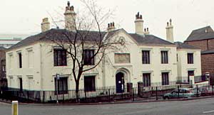
Plumtre Hospital (1998).
I now propose to make some remarks respecting the open space, in former times known as Bridgend, at the eastern terminus of Narrow Marsh and the northern end of what is now called London Road, but which was in my recollection, and in that of many others, entitled "Bridge Street" (from the large old Leen Bridge, otherwise the "Bridge of Nottingham"). Bridge Street once terminated at what is now called Plumptre Square; a name derived from the Plumptre Hospital at its rebuilding, in August, 1823, as mentioned by the aldermen who were present when the first stone was laid. The earliest reference I find to this place is in the Records, vol. i., page 179, 1362, as Brighend (Finis Pontis), also as Brigend, Bridge End, and rarely Bridgefoot, but from 1801 until 1823 it had been known as Red Lion Square, which unworthy designation was superseded by one much more becoming in its relationship with the past in that part.
Some attention will now be given to Fisher Gate, together with the old lanes or passages once at its eastern end, including Pennyfoot Row, Pennyfoot Lane, and Pennyfoot Stile. Respecting the first, it is an old name, but not of much historic note. In the Records, vol. i., page 431, it appears to be first referred to in 1315 as Vicus Piscatorum. It was also known in olden times as Fesshergate, Fysshergate, &c. To the eastern end and near it, various changes have been made in connection with the thoroughfares, during and since Deering's time (1749).
On referring to Deering's History, page 13, respecting Pennyfoot Lane, he says "see Back-Lane;" from this it appears that a short time before, the latter name had been substituted for the former. Pennyfoot Lane is a peculiar and interesting title, recalling various incidents connected with the past, and it is one of those which have died hard. Various theories have been advanced respecting the name "Pennyfoot," but nothing which I considered to fully explain it. Deering, on page 13, alludes to Pennyfoot Lane; Pennyfoot Row; and on page 122 to Pennyfoot Stile; and during his time the three different ways of using the name appear to have been commonly accepted.
I have long thought it probable that the term "Pennyfoot" originated in connection with the stile, which formed a portion of the town boundary in that part. On various occasions in my remembrance, and also of many others, toll was demanded in accordance with a Corporation list at a number of the entries into the town, from those bringing different specified articles and matters for sale at fairs. This, however, was a pathway purely for foot passengers, and across fields which were in Sneinton parish, and over the stile into Nottingham ; and I can easily imagine, from being one of the ways into the town, that pennies were frequently demanded and paid there as toll in former times; and that Pennyfoot Stile originated Pennyfoot Lane and Pennyfoot Row. Some are still left who will recollect the stile and foot road, as it was full sixty years since. Deering, in his eastern view of the town, shows it plainly.
Respecting Pennyfoot Row (see Deering's plan), it reached from the ends of Fisher Gate and Carter Gate to Backlane (which name the people rejected), now Water Street; the term "Row " being no doubt applied from the houses being mainly on the north side. In 1780, Willoughby's Hospital, which was formerly on Malin Hill, was rebuilt in what Deering terms Pennyfoot Row, and from that date it has been known as "Willoughby Row;" and so called by those living there when voting, etc. Pennyfoot Stile, on the town side for a short distance, was a narrow footpath between fences, and without houses in 1780 and also later. A few years since, Fisher Gate was advanced eastward to Water Street, and old Pennyfoot Row or Willoughby Row is now included in it.
During the years 1791-1792, Denison's cotton mill was built on the south side of and close to Pennyfoot Stile, and within a few yards of the Beck rivulet, which runs near there and bounds Nottingham and Sneinton. In going from this mill by footpath either to Sneinton Hermitage or to Sneinton Church it was necessary to cross not only Pennyfoot Stile, but also the little wooden bridge over the Beck. For those times, the mill was an exceedingly fine structure, and of great height. There are a few good illustrations of it still to be seen when on fire, November 28th, 1802; one of them, in the Mechanics' Institution, shows the mill to have been seven storeys high, each having fifteen windows, and the old plan says 115ft. long. About 300 people were thrown out of work by its destruction, and unfortunately it was not afterwards rebuilt. I was never able to fix the exact spot occupied by Denison's mill until assisted by the unique plan of the town which has been noticed.
What was called Pennyfoot Stile is now much enlarged and entitled Pennyfoot Street, and as regards the roadways, that part has during the last fifty-eight years been entirely transformed, and the Beck rivulet covered over. There were a number of different ways of spelling this singular name in olden times, such as Penyfot, Penyfut, Penyfote, and Pennyfootlane; or, as the case might be (see above), Pennyfootstile, for they are distinct places; yet in the Borough Records, vol. ii., page 445, the editor appears to consider that Penyfot lane (1408) was Pennyfoot Stile.
Deering, on pages 12 and 13, explains the case very differently, and tells us sufficient to decide that what was once Pennyfoot lane was renamed Back lane, then Water lane, and is now Water Street. The editor, in the Records, vol. i., page 437, says "Penny Foot Stile; called Pennyfoot Lane by Thoroton," and it is numbered 83 on his plan of the town (page 490). On Deering's plan the same place is numbered 24, and in the "References to the Plan," that number represents "Pennyfoot Row."
This is a grave discrepancy between our two old historians, but I consider that in such a case, Deering's version is more worthy of belief than Thoroton's, for Deering resided in Nottingham, and Thoroton twelve or fourteen miles away in the county, therefore the former would be far more likely to be acquainted with the small thoroughfares, &c., than Thoroton. As Pennyfoot Lane ran northwards, and Pennyfoot Stile eastward, they must be distinct, and the south end of the former and west end of the latter were contiguous, according to Deering.
On his plan of Nottingham (next to page 490), respecting No. 58, Thoroton says "Swine gate;" a name apparently unknown in the Borough Records, which for reference in such cases is usually a very reliable work. In them it is designated "Swine Green," a title which is also generally given to it in the 18th century and earlier, in our plans, directories, and reliable histories. In these matters of detail, I should be sorry even in appearance to charge Thoroton with lack of care, but rejoice in the fact that those coming after him in Nottingham have far superior opportunities of obtaining knowledge respecting Nottingham and verifying historic statements, than were possible in his time.
The first reference to Swine Green which I have observed, is in the Borough Records, vol. ii., page 63, 1408, when the Mickletorn jury say or report "that Edmund Wheatley has made a wall upon the common ground on the Swynegrene." Those who carefully peruse the Records will find that such acts were far too common amongst all classes of our ancestors. Except in spelling, there was little change in the name until early last century, for at an election in 1806, all voters for that part mentioned Swine Green as the place where they resided, whereas when voting in 1812, all entitled it Carlton Street. It has therefore been known by its present name for about a century.
In this part and commencing westward, a few yards within Gridlesmith Gate (Pelham Street), was the town mansion of the Gregory family, which after some changes many years since, was occupied by Wright's bank. By a singular coincidence, and commencing early in the 17th century, there were two families named Gregory occupying a prominent position in Nottingham, but probably in no way connected, except by name. In 1527-28 Thomas Gregorie was a sheriff, and after that at various intervals, others of the name were mayor, &c., until 1620-21, when Marmaduke Gregory occupied that position.
I wish, however, to make a few remarks respecting William Gregory, butcher; see Records, vol. iv., page 320, 1614, where it is said that he was fined for refusing to be "Chamberlayne," yet in 1616-17 he accepted the office. In 1618-19 he was one of the sheriffs, he afterwards became an alderman, and was mayor in 1632-33 and 1639-40. He was no doubt a most successful man in business, as proved by the property he purchased and bequeathed, and the positions occupied by his descendants.
His grandson, George Gregory, 1638-1688 (see pedigree, Godfrey's History of the Parish and Priory of Lenton), owned about half the land as now bounded by Carlton Street, Broad Street, Parliament Street, Clumber Street, and Pelham Street. This refers to the eastern and largest portion of this large piece of town land, and the Records, vol. 5, page 3x8, as regards the family house mentioned above, which was being built in August, 1674, informs us that it was considered by the council whether any encroachment should be allowed upon the street, and they ordered " that George Gregory Esquire shall not build upon the streete and Towne's Wast on the Swyne Green, without an Annual rent or acknowledgement to the Mayor and Burgesses."
This was a gross case of encroachment, and entirely unnecessary, for the land reached northwards to Back Side (Parliament Street) presumably 700ft., and was probably the largest piece attached to a house at that date in Nottingham, and shown as exceeding what was connected with Thurland Hall. In the remembrance of many still alive, the top of Pelham Street was but just wide enough, with very narrow causeways, to allow one vehicle to pass into it from Carlton Street (Swine Green), and in such a case the gain or loss of one yard only would make a material difference.