
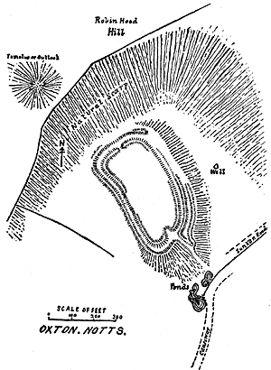
Oldox or Hodox camp, Oxton
by Mr. T. Davies Pryce.
The history of early man is indelibly written in the earthworks which score and scar the face of the land, and could we but read them aright, they would furnish us with valuable evidence of his habits and customs.
Unfortunately archaeology in its best aspect, that of scientific spade-work, is as yet only in its infancy, and little more can be done than the formation of an approximate guess as to the dates and uses of an earthwork of this type.
Still, even our present imperfect knowledge justifies certain conclusions. The main features of this camp are sufficiently characteristic to warrant the statement that it is Celtic in its origin. In the absence of archaeological finds it is, however, impossible to say whether it belongs to the Romano-British or the pre-Roman period, or even to the far off Bronze age. Possibly excavation would reveal evidence of successive habitations during all these periods, and even in later times.
The camp is situated about a mile and a half to the N.N.E. of the village of Oxton, is roughly oval in form, and covers an area of some four-and-a-half acres. It is placed in a comb formed by a bend in the hills, and is thus to a considerable extent sheltered from the elements and from the sight of the enemy. It is a curious fact that a number of such camps exist, commanded, as they are, by superior heights in the immediate neighbourhood. The only explanation of this remarkable arrangement appears to be that they were definitely habitation sites—as distinguished from camps of refuge—and that the heights in their proximity were used as outlooks from which the approach of the enemy could early be signalled.
The rounded and partially artificial eminence to the north-west probably served this purpose. This eminence might, however, have been sepulchral in its origin. This point and the natural height to the immediate north command a wide range of territory.
The most interesting feature of the earthwork is its multiplicity of circumvallation. Three tiers of ramparts rise one above the other on the sharp slope of its eastern side, and elsewhere the camp is defended by a double rampart and an intervening fosse. The method of entrance is also peculiar. The approach to the camp is almost directly from the south, where a raised causeway terminates near a pool of water. Proceeding by a sunken way—now much silted up— an apparent or sham entrance is encountered. Here the sunken way divides and is continued by means of two ditches —which encircle the camp—to the north where the real or actual gateway is found.
This arrangement of multiple rampart and circuitous entry is distinctly an early characteristic as evidenced by a like method of defence in the great camps of Maiden Castle and Badbury which date back to the Bronze age and possibly to an earlier period. Later fortifications, i.e., Norman and late Mediaeval, rarely, if ever, possess this feature.
History also supports the view that this type of circumvallation was a feature of early forts. Thus the Monk of St. Gall, writing in the 9th century, describes the vast Hunsring of the Avars as consisting of nine concentric ramparts.
The Book of Leinster (compiled 1150-1160) describes the dun of Aedh, King of Ireland, A.D. 624-639, as being surrounded by many ramparts.
Giraldus Cambrensis (12th century) states that the early forts of Ireland were mostly triple fossed—unde et fossata infinita, alta nimis, rotunda quoque, et pleraque triplicia.
To the south the camp is approached by a raised causeway, the continuation of which can be traced to a lane which leads to Oxton.
To the east also a deeply sunken road leads from over the ridge of the hill to the southern extremity of the earthwork.
These trackways are, I think, sufficient evidence of the importance of the place and of its—at one time—permanent occupation.
It must, however, be noted that probably these roadways were in use long after the camp was deserted, for, as Mr. Blagg has pointed out, there is evidence of later cultivation on the hillside to the south-east.
The greater part of this camp—its southern two-thirds— has evidently been artificially raised with much labour.
Lastly it should be noted that the water supply is abundant, consisting of a small streamlet and two ponds.
The Rev. W. Laycock, whose courtesy I wish to acknowledge, has pointed out to me a walled well, shown on the plan.
Whether this dates from the same period as the earthwork it is impossible to say. Judging by the infrequency with which wells are found in connection with early camps, I am inclined to look upon it as a later addition.
The numerous tumuli and small camps scattered about this district suggest a comparatively dense population in early times.
No actual discoveries have been made on the site of the earthwork, but bronze finds have come to light at Combs, about a mile to the north, and somewhere in the immediate neighbourhood Major Rooke, in the 18th century, explored a late Celtic or, more probably, Anglo-Saxon barrow.
Excavation of this interesting little camp would, I feel sure, yield interesting results.