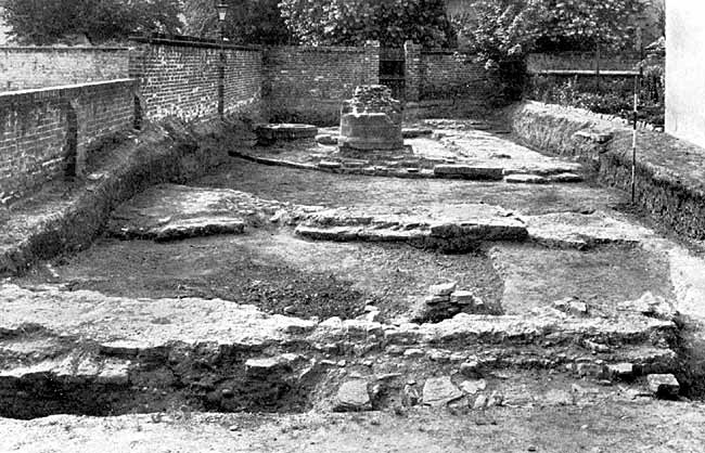
Lenton Priory–General view of the excavations from the North.
2. Results of excavations, 1935-6.1
Previous attempts to reconstruct the ground-plan of Lenton Priory have been based almost entirely upon conjecture. As a result of excavations begun in the autumn of 1935, the position of the monastic church has been definitely established. Much also has been discovered of the plan of the church. As monasteries were fairly regular in plan, the discovery of the position of the monastic church is of first-rate importance. Although it is evident that streets, houses, yards and gardens cover a large portion of the site of the monastery, opportunities may occur to excavate at fresh points and this account may be supplemented in later volumes of the Transactions.
Early in the 19th century, William Stretton bought a portion of the Lenton Priory demesne lying close to the priory. Here he built himself a house, giving it the name of “Lenton Priory.” Greatly extended, it is now occupied by the Sisters of Nazareth and is known as Nazareth House. J. T. Godfrey, in his History of the Parish and Priory of Lenton2 and in his introduction to the Stretton Manuscripts,3 states that Stretton’s house occupied the site of the prior's lodging. As, however, no evidence is given to show the reason for supposing the foundations discovered to be those of the prior's lodging, it is not wise to accept the statement.
According to Godfrey, Stretton made a series of excavations on the site of Lenton Priory to ascertain its ground plan, and “not only dug out seven very fine specimens of the ancient pillars to the height of a few feet from their bases,” but was also “enabled nearly to trace out the ground plan of the whole.”4 Notes made by Stretton on these excavations were not to be found with the rest of his papers, and very little of the information he obtained concerning the ground plan has come down to us. In the Introduction to the Stretton Manuscripts5 it is stated that the Norman font, the most beautiful of the relics of Lenton Priory, now in Holy Trinity Church, New Lenton, was unearthed during Stretton’s excavations. According to other statements, however, the font was presented to Stretton by the churchwardens.6 This seems to be the more probable, for Throsby's edition of Thoroton7 (1797) mentions the font in a description of the parish church of Lenton5 and gives a rough drawing of one of its sides. It seems that Stretton’s interest in archaeology served to destroy rather than to preserve the remains of Lenton Priory. By building his house on a part of the monastic site he effectively hid from future generations a considerable portion of the foundations of the priory. His failure to publish a plan of the monastery, or put his notes into permanent form, has resulted in a lamentable loss. From his own statement it is known that in building his house he took up thousands of the monastic tiles.8 A few tiles from Lenton Priory are in the Castle Museum. What has happened to the rest may be imagined. The most important information about Lenton Priory in the volume of Stretton Manuscripts is to be found among notes called “Nottinghamshire Memorabilia.”9 In these, the statement is made that the cloister and cloister buildings were on the south side. This appears to be correct. Another important statement is that the end of the monastic church was semi-circular. The truth of this Has been proved beyond doubt during the recent excavations.
For the last fifty or sixty years, interest in the buildings of Lenton Priory has been centred upon the remains of two circular piers in a garden at the corner of Priory Street and Old Church Street. Because of a paragraph in Godfrey’s History of the Parish and Priory of Lenton,2 these have been wrongly assumed to be part of the calefactorium.10 Godfrey’s paragraph is as follows :
“These bases are five feet in diameter and five feet apart, and exhibit the base mouldings entire. Mr. Swann (Rev. Kirke Swann, M.A. of Forest Hill, Warsop), informs us that when his father purchased the garden, there were bases of four pillars remaining, of equal size and at equal distances apart, forming a square. Two of these have now disappeared except some portion of the foundations, which have been found in digging at the spots pointed out by Mr. Swann . . . These pillars must have formed part of the great calefactorium.”11
The absence of any kind of evidence that the piers had been part of the calefactorium prompted the excavations of 1935. The desire to test Godfrey's statement was increased by the difficulty of imagining any part of a monastery which would have four massive pillars only 5 feet apart, and in the form of a square. When digging was begun, it soon became clear that there had not been four piers in the form of a square and that the two bases were part of the arcade piers of the apsidal east end of the monastic church. An account of the discoveries to date is given below. Nothing has been included on the plan for which there is not sufficient evidence. Some possibilities are mentioned in the text, but are not included on the plan.
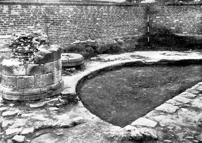
Lenton Priory—Apsidal east end showing remains of piers of Norman arcade.
During the excavations in the garden at the corner of Priory Street and Old Church Street, it was discovered that the two piers mentioned in the preceding paragraph had been built upon a semi-circular foundation 7 feet wide, with an internal diameter of 26 feet. Across the diameter of the semi-circle was another foundation-wall also 7 feet wide. Such foundations have been found across the apsidal ends of other churches, but their purpose is hard to discover. It was obvious that other piers had existed forming a semi-circular arcade, the two ends of which extended in a westerly direction along the main body of the church after the manner of the arcades of St. Bartholomew’s, Smithfield, and of the chapel in the keep of the Tower of London.12 Two trenches driven into the next garden proved this.13 The chamfered base of a pier of the north nave arcade and the foundations of the south nave arcade were discovered in this garden.
One of the remaining piers of the apsidal arcade stands to a height of 4 to 5 feet. It is circular in form with early-Norman base comprising of a chamfer and flat torus-like moulding. The pier is faced externally with millstone grit and filled with rubble and lime mortar. Only the base of the other pier exists.
Surrounding the apsidal arcade was revealed an ambulatory 13 feet wide, the level of which appears to have been slightly higher than the floor of the apse. To the north of the ambulatory were discovered the remains of an apsidal chapel.14 In many places there were traces of lime mortar screed which was formerly paved with tiles. Only a few tiles came to light, but this did not cause surprise as the site had been disturbed by Stretton and by others since his time. A trench driven across the land between the apsidal chapel and the present graveyard disclosed no foundations.
There is good reason to believe that portions of the wall of the present graveyard (marked B and C on the plan) were originally the face and return of the north transept. At the angle may be seen remains of Norman flat buttressing. Such excavations on the east wall of this north transept as the proximity ot inhabited houses would allow, suggested that an apsidal chapel had existed there. For about 50 feet of its length the south boundary wall of the present graveyard (marked A on the plan) shows signs of having been the external face of the north aisle of the monastic church. If this wall is approached through one of the yards on the north side of Priory Street, the rubble filling of the wall may be seen. It is hoped that further excavation along this wall may determine the length of the nave. From what has already been done, it is clear that part of Priory Street covers the site of the south aisle and transept of the church, and that houses, yards and gardens on the north of this street stand where the nave and north aisle stood. It would appear that the overall width of the nave and aisles, including the thicknesses of the walls, was approximately 80 feet, whilst the width over the transepts approached 140 feet.15
The stones used in the construction of the pillars, walls and foundations, described in the preceding paragraphs, are chiefly local stones. All the foundations are of magnesian limestone, commonly called Bulwell stone. All the facings of pillars and the wall near the present graveyard are of very hard and resistant millstone grit, probably from its nearest local outcrop, which occurs over wide areas just beyond Derby. In the filling of the pillars there is a variety of local rocks, including magnesian limestone, and skerry bands from the Keuper Marls of the Lenton district. Another mass of stone consists of the very hard Barytes cemented sandstone from Bramcote. This is the stone which forms the cap rock of the Hemlock Stone.
(1) In writing this section I have been
greatly helped by the advice and suggestions of Mr. F. W. C. Gregory, F.R.I.B.A.,
and Mr. H. H. Brittle.
(2) p. 222.
(3) p. v.
(4) Godfrey: p. 222. Stretton MSS.—Introduction, pp. v, vi. (2) p. vi.
(5) Godfrey, p. 279. See also E. D. Ginever, The Parish and Priory of Lenton,
1930, pp. 66-68.
(6) Vol. II, pp. 204, 224.
(7) The church now called the Priory Church.
(8) Stretton MSS., p. 172.
(9) Ibid., p. 209. (2) p. 222.
(10) A plan of Lenton Priory based upon this assumption was printed in Some Account
of the Priory of Lenton by E. A. Beresford and H. M. Leman, 1893, p. 5, and in
The Parish and Priory of Lenton by Rev. E. D. Ginever, 1930, p. 41. The church
and, indeed, all the monastic buildings are placed too far to the north. The
measurements are purely arbitrary. No side chapel is included in the plan. The
prior’s lodging is shown separate from the rest of the buildings, although no
evidence exists that this was so.
(11) Godfrey’s next supposition that “some massive fragments of masonry from
which the external ashlar casing has been removed,” were part of the wall of
the north transept appears to be correct. This makes it all the more surprising
that he considered the bases of the piers to be part of the calefactorium.
(12) The Cluniac Priory of St. Pancras, Lewes, had this feature
(13) For permission to excavate in this garden, I am indebted to Mr. Lovett the
owner, and Mr. T. Berry the tenant.
(14) English Cluniac houses did not follow one uniform plan. The 12th-century
churches of Lewes, Thetford, Castle Acre and Dudley, ended in an apse. Lewes,
the chief Cluniac foundation in England, like Lenton, had an ambulatory. The
others mentioned did not. See plans in the Official Guide to Lewes, ed. by W.
H. Godfrey, F.S.A., and guides to Thetford and Castle Acre: H.M. Office of Works.
See also English Monasteries, A. H. Thompson, p. 45.
(15) Some idea of the size of the monastic church at Lenton may be obtained by
comparing the measurements given with those of other churches: Southwell Cathedral
(as now standing) 72 feet; 135 feet. Lewes Priory (Cluniac) 87 feet 6 inches;
161 feet. Castle Acre Priory (Cluniac) 67 feet 10 inches; 111 feet. Thetford
Priory (Cluniac) 66 feet; 124 feet. Dudley Priory (Cluniac) 33 feet; 92 feet.