A comparison between the perambulations of 1232 and 1588 shows a great addition to detail in the boundary marks. In 1232 the regarders were content when they left Linby Mill to specify 'thence descending by the same water (Leen) to the Town of Lenton, and thence as that water was wont of old time to run as far as to the water called Trente,' but in 1588 for the same section was specified more fully:
"From the Trent Bridge at Nottingham, the same ascendeth after the River of Trent through Wilford Pasture to the place where the old course of the Leen falleth into the Trent which is directly against Wilford Church, where is found three courses of the old Leen and two of them do fall into the Trent in one stream directly over against the said Church, but that which is most west of the said three courses is old Leen. From the Trent it ascendeth first through Wilford Beast Pasture and Wilford Meadows to a ditch and a hedge which go southward from the Old Leen towards the Trent. And then it parteth Lenton Holmes clearing them on the south west from Wilford Meadows and clearing them on the north west, and so goeth to Willow Holme leaving it on the East, and there the highway from Wilford to Lenton is on the West, and then the same Old Leen crosseth over the said Highway at the south end of Wilford Lane and so goeth into the right course of the Leen on the West side of the Abbey Mill of Lenton, and so ascendeth to Buttrey Mill, then to another mill at the North end of Lenton, then to Radford Mill, so to Allin Mill from thence to Bobbers Mill, then to Lovett Mill, so to Yellandhall where is a mill also, from thence to Basford where the stream is turned from its old course to serve a mill there, and it is turned from that old course at a place named the Old Carr, and it cometh into its course again a little beneath Basford Church, which Church is on the West side of the said river, and so from Basford to Bulwell, and then (as the old Forest Book saith) it leaveth the Leen and goeth from thence Westward into Thirswell and from thence unto the hill of Hyndale and thence to Milne Gate, from thence to Watnow-stighe, then to Hucknall Ditch, and so by the same ditch and by Bulwell Grounds it goeth to Rudds Ditch and so to the Leen—which meeres because that most of them are worn out of mind and unknown to the inhabitants of Bulwell we passed after the Leen to the Walkmiln and so to the ford above Walkmiln at Beskwood Parkside, then to Waterfall gate on to Lyndeby Mill."
The rest of the perambulation is similar in its extensive details.
Again, where one perambulation speaks of following the Doverbeck to the Trent and from the Trent to the Bridge of Nottingham, the later parambulation for the same section adds the names of Salterford Dam, Oxton Mill, Epperstone Mill, Grimesmoor, Woodborough Mill, Lowdham Mill, Gonalston Mill, Bakers Mill, Hoveringham Mill, Caythorpe Mill, and the site of the Old Mill at East Bridgford and many others.
Several places named in the perambulations are matters for speculation. Conyngeswath1 has been identified with the place marked on the modern ordnance survey as Conjure Alders near Haughton Park; Blakestone Haw appears to have been between Rufford and Hexgreave, but in spite of the additional note in the 1662 perambulation "now known as Southfellers" cannot be found. Estrelde, Hayter or Otter Bridge may perhaps have been at Newbound Mill near Pleasley; and Milneford Bridge near Fackley Hill on the Tibshelf to Skegby road. Between the old castle of Annesley and Nuncargate, Scolgat, Scolestighe, Tharlasty all remain to be positively identified.
In the patent rolls and close rolls there are many records of grants made by the king of privileges, of deer and of timber, both to private individuals and also to the abbeys, the churches, or for national purposes. In the early part of the 13th century, for example, a grant was made of six oaks for the repair of Newark church, and ten joists for work on the church at Wurmegay, Norfolk. In 1281 Thomas, Bishop of St. David's, was granted four live bucks and eight live does to stock his park at Plesele. In 1287, Robert de Typotot, constable of Nottingham castle, was granted four oaks from Bestwood for the repair of the castle. In 1349 the wood in Linby Hay was ordered to be cut down and sold, and the proceeds to be expended in enclosing Bestwood park. In 1323-4, at the time of the Gascon campaign, wood was granted for the construction of springalds and quarrells. In 1287 the Abbot of Rufford, by his charter, took 476 oaks and 253 blitrons (saplings) for building purposes, "therefore he is quit."
Wood from the forest was also in demand for use in building the ships of the fleet, and great beams of timber 47 feet long, 13 inches in diameter at the small end were required for the rebuilding of St. Paul's after the great fire of London.
 |
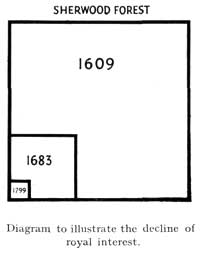
The forest frequently suffered damage and loss through storms and fire, in addition to the depredations of those who cut down trees without licence. In 1222 a great storm caused immense damage throughout the land and orders were sent forth for the sale of fallen timber. At the latter end of the forest's history, in 1714, a hurricane uprooted hundreds of trees; and Bailey gives an amusing account of the financial side of the affair. The value of the fallen timber was estimated at £2,473 6s. 4d.; but when all claims for surveying and superintendance, and for fees, poundage, customary allowances, patent salaries, and other expenses had been met, not a penny reached the Treasury.
During the great drought of 1624, Sherwood Forest suffered from a great fire, and White (Worksop, the Dukery, and Sherwood Forest) quotes from a manuscript preserved in the British Museum in which it says that there was such a mist of smoke and particles that people thought it was an eclipse of the sun, but when the true cause was discovered "there came command from the justices to raise the country there about and to bring pickaxes, spades and shovels to make dikes and trenches to break the fire in the forest." This fire, four miles long and half a mile wide, was stopped at the wood between Mansfield and Nottingham. A very similar, though not quite so extensive, fire broke out in the woods near Edwinstowe in the late nineteen-twenties, with a similar effect of an eclipse.
1 Firth, J. B., Highways and Byways in Nottinghamshire, p. 279. Place Names of Nottinghamshire, E.P.N.S., Vol. XVII, pp. 69-70.
