< Previous | Contents | Next >
There were many Indictments against the Inhabitants of Parishes and places for not repairing the common way, highway, or King's way; or "for non repair of a "layne" or "venelle," &c, &c.
The name of the way is not always mentioned in the records.
These records of Indictments are interesting at the present day, as they show to some extent the courses of the old highways, and where there was most traffic. It may be assumed that the parishes and places indicted were the more populous and important.
The following is a list of the Parishes and places indicted:
(1). Near Nottingham.
| Basford | Lenton | |
| Bilborough | Radford | |
| Broxtowe | Snenton | |
| Bulwell |
Among the roads named in the Indictments of these Parishes are:
[In Basford]. " From Bobbers Mill to fields of Basford " (1692).
[In Basford.] " From Two Mile Thome to Henry Wards " (1692).
(2). West of Nottingham.
| Woollerton | Greasley | |
| Trowell | Awsworth (spelt Alsworth) | |
| Strelley | Newthorpe | |
| Cossall | Brampcote | |
| Nuthall (also spelt Notehall) | Chilwell | |
| Kimberley | Watnall |
Among the roads named in the Indictments of these Parishes are:
"A highway from Woollerton to Strelley" (1676) ;
"The Dead Lane leading from Trowell to Cossall" ;
"Highway [in Nuthall] from Nuthall to Basford" (1678) ;
"Bridleway [in Greasley and Nuthall] from Gilt Hill to Awsworth" (1684);
"Highway [in Kimberley] from Gilt Lane to Asworth " (1678) ;
"From Nuthall to Nottingham" (1692);
"Guiltbridge Lane" and "Guilt Lane" [in Nuthall, Awsworth and Greasley];
"Way from Greasley Church to Nottingham" (1692);
"Way [in Greasley] from Moore Green to Willey Wood" (1692); and
[In Watnall] "From Watnall to Graysley" (1692).
(3). In the Soar Valley.
| Ratcliffe on Soar | Sutton Bonington | |
| Kingston | Normanton on Soar |
Among the roads named in the Indictments of these Parishes are:
"Way [in Kingston] near Kegworth Bridge" (1621);
"Kingsway [in Sutton Bonington] at Ravenhedge" (1614);
"Kingsway between Sutton Bonington and Normanton" (1614)
(4). South of Nottingham.
| Cortlingstock | Hickling | |
| Widmerpool | Plumptree | |
| Broughton Solney. |
Among the roads named in the Indictments of these Parishes are:
[In Plumtree] "Highway to Market" (1603); and "Kingsway in Plumtreefield" (1613).
(5). Between Nottingham and Newark—North of the Trent.
| Carlton | Gonaldstone (also spelt Goniston | |
| Gedling | and Gunalston) | |
| Burton Joyce | Thurgarton | |
| Bullcott | Hoveringham (or Horringham) | |
| Stoke Bardolph | Gibbesmere | |
| Lowdham | Bleasby | |
| Gunthorpe | Fiskerton (spelt ffisgarton) | |
| Woodborrow | Morton | |
| Epperstone | Rolleston (spelt Roldeston) | |
| Aram (Averham). |
Among the roads named in the Indictments of these Parishes are:
"From Carleton to Nottingham" (1692);
"Way between Gedling and Carlton" (1682);
"Highway [in Gedling] between Burton hedge and the Stone Bridge" (1683);
"Highway [in Burton Joyce] in a certain place called Crockfield" (1634);
"Kingsway [in Gonaldston] leading to Southwell" (1681);
"Kingsway [in Hoveringham] leading to Southwell" (1681);
"Kingsway from Thurgarton to Hoveringham" (1680);
"From Hoveringham boate to Gunthorpe" (1692);
"Road from ffiskerton to Ronaldston" (1694);
"The Parklane Yate between Lambley and Lowdham;
"Between Gunthorpe Towne End and ffearholme Bridge" (1690).
(6). Between Nottingham and Newark—South of the Trent.
| Wilford | Scarrington | |
| West Bridgford | Car Colston | |
| Adbolton | Hawksworth | |
| Gamston | Staunton | |
| HolmePierrepont | Sibthorpe | |
| Codgrave | Cotham | |
| Kynolton | Elston | |
| Cropwell Bishop | Syerston | |
| Colston Bassett (or Coulston) | East Stoake | |
| Grandby | Hawton | |
| Saxondale | Kneeton | |
| East Bridgford | Basingfield | |
| Bingham | Flintham | |
| Whatton | Wiverton | |
| Aslackton |
Among the roads named in the Indictments of these Parishes are:
"The Kingsway [in East Stoake] called the fosseway leading from Newark to Bingham (1678);
"Way [in Elston] leading from Newark to Nottingham" (1694);
"Road near Ludley Cross Corner leading from Bingham to Aslockton and Skarrington" (1694);
"Kingsway at Car Colston leading from Screaveton to Skarrington" (1680);
"Highway [in Hawton] from Markall Bridge to Ladywelle" (1677); (see p. 87)
"Spring Lane leading from Newark to Marcom Bridge" (see p. 87);
"From Whatton to Thirrabridge" (1690);
"Road from Whatton to Saxondale Lane End" (1696);
"Part of road from Grandby to Bingham called Whiplinge" (1696);
"Highway in Long Flash" [Gamston and West Bridgeford] (1617);
"Kingsway between Gamstone and Adboulton" (1634);
"Holme Lane" and "Holme Lane from the Fox and Crown to Codgrave Field";
"Ways leading to Codgrave and Basingfield" (1686); and
"Highway between Grandby and Sutton" (1634).
(7). Near Newark.
Newark
Balderton
Norgate (Newark).
Among the roads named in Indictments against these Parishes are:
"Kingsway [in Newark] between Newark and Coddington (1615);
and "Highway [in Newark] near Barnby Gate End" (1630).
(8). Between Newark and Mansfield.
| Kelham | Hockerton | |
| Upton | Kirklington | |
| Southwell | Eakring | |
| Easthorpe | Malebeck |
Among the roads named in Indictments of these Parishes are:
"Road [in Kelham] to Aram" (1696);
"From Averham to Upton" (1690 and 1696);
"Road [in Hockerton] to Kirklington (1696);
"Road [in Hockerton] from Upton to Kirklington" (1696); and
"Road [in Hockerton] from Upton to Hockerton" (1696).
(9). Between Newark and Worksop.
| Kelham | Kneesall | |
| Caunton | Wellow | |
| Deanehall | Perlethorp | |
| Middlethorpe | Walesby | |
| Knapthorpe |
Among the roads named in Indictments of these Parishes are:
"Way [in Knapthorpe] from Knapthorpe to Southwell" (1689);
"Ways [in Walesby] between Willoughby and Kirton" (1609); and
"Way [in Deanehall] from Deanehall to Beesthorpe" (1689).
(10). Between Newark and Gainsborough—East of the Trent.
| Wynthorpe | Clifton | |
| Holme | Girton (or "Gorton") | |
| Langford (spelt "Lanford") | Harby | |
| South Scarle | Spawdeforth | |
| Besthorpe | Wiggsley |
Among the roads named in Indictments of these Parishes are:
"Highway [in Holme] called Steedfouldyate between Holme and South Collingham" (1634); and
"Road in Wathholme " (1617).
(11). Between Newark and Retford—West of the Trent.
| South Muskham | Markham Magnum | |
| North Muskham | East Markham | |
| Cromwell | West Drayton | |
| Carlton on Trent | East Drayton | |
| Sutton on Trent | Darleton | |
| Normanton on Trent | Askham | |
| Marnham | Headon | |
| Dunham | Gamston (spelt "Gampstone") | |
| Ragnall (or "Raggenhill") | Ordsall (or "Ordeshall") | |
| Weston | Fledborough | |
| Tuxford | Norwell | |
| Laxton | Willoughby |
Among the roads named in Indictments of these Parishes are:
"Way [in South Muskham] from Kelham to Carleton" (1686);
"Lane [in Willoughby] leading from Norwell to Sutton";
"From Weston to Tuxford" (1686 and 1696);
"From Gampstone to East Retford" (1686);
[In North Muskham] " between Newbridge and Deanehall" (1687);
"Road from Ragnall Milne to Dunham Mooregate" (1694);
"Highway [in East Markham] at Southern End of Merryall Bridge" (1634);and
"Highway [in East Markham] leading to Tuxford and Merriall Bridge"(1687); (see p. 83)
"Highway at both ends of Merriall Bridge"; and
"Highway [in West Drayton] at Northern End of Merryall Bridge" (1627); (see p. 83);
"Comon Highway situate on the Moore" [in Markham Magnum]; (1606)
(12). North-East of Retford.
| Bollam | Beckingham | |
| Sturton | Gringley | |
| Clarbrugh | Misterton | |
| Hayton | West Stockwith | |
| Sawneby |
Among the roads named in the Indictments of these Parishes are:
"From Sturton to Littleborough" (1686);
"Pukley Hill between Retford and Grove";
"Lane [in Clarborough] leading from Spitle Hill to Gringley Field";
"Highway [in Clarborough] on the Higher Baulke" (1696);
"King's Highway in Hayton leading from North Wheatley to East Retford Market Townes, in a certain place there called Stonepit Close (1612);
"Highway [in Sawndby] between East Retford and Gainsborough" (1634); and
"Highway in Saundby Marsh" (1634).
(13). North of and near Worksop.
| Harworth | "Gaytforth " | |
| Stirrop | "Rattcliff" (Worksop) | |
| Blyth | Worksop |
Among the roads named in Indictments of these Parishes are:
"Road [in Blyth] from Market towne of Worksop to Market towne of Bawtry" (1691).
(14). Between Mansfield and Nottingham—West of the County.
| Mansfield | Annesley (spelt "Ansley") |
| Skegby | Selston |
| Sutton in Ashfield | Hucknall Torkard |
| Kirkby in Ashfield |
Among the roads named in Indictments of these Parishes are:
"Kingsway [in Annesley] called Salmon Lane leading from Selston to Annesley" (1682);
"Kingsway [in Kirkby in Ashfield] leading from Pinxton to Kirkby" (1682);
"Lane [in Kirkby in Ashfield] between the Forest and Pinxton";
[In Selston] " from Wansley to Nottingham" (1692);
[In Selston] " from Barrowgate to Wansley" (1692);
[In Selston] " from Pyehill erga the Bridleway to Barrowgate" (1692);
"Highway [in Sutton in Ashfield] from Mansfield to Alfreton" (1678);
"Way [in Sutton in Ashfield] from Sutton to Fullwood, leading to Pinxton"
(1682); and [In Sutton in Ashfield] " from Sutton to Mansfield" (1087); and
"Mirehole Lane leading from Mansfield to Sutton."
It will be observed that the greater number of the Parishes indicted were situated in what may be termed the eastern half of the County, in close proximity to the River Trent. Much of the western half of the County was merely forest.
From the particulars given in the Indictments, and from old County maps collected by the late Hon. Frederick Strutt included in "The Belper Library" belonging to the Notts. County Council, it would appear that the principal County roads were the roads from Nottingham to Newark, and from Newark to the North.
From Nottingham to Newark.
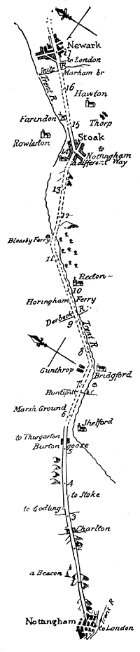
Facsimile of survey of road from Nottingham to Newark.
In a map by Robert Morden dated in 1680, the road from Nottingham to Newark is shown via Carlton, Burton, Gunthorpe, Hoveringham, Bleasby, across the river at a point called in other maps Bleasby Ferry, to Stoke, where the road joined the Fossway to Newark. This was evidently the chief road to Newark. It is so shown also in several other maps of later date up to the end of the eighteenth century.
The road is particularly shown in "A Survey of the Road from Nottingham to Grimsby in Lincolnshire," dated 1771. This Survey is among the maps in "The Belper Library." An extract from this Survey is shown opposite this page.
Shortly after the date of this Survey of 1771 the route to Newark must have been altered, as in Cary's map in 1801 a road is shown on the West of the Trent via Lowdham and Thurgarton, &c, apparently more or less identical with the road used at the present day.
The route from Nottingham to Newark via the Fossway is evidently of much more recent date. The "Fassway" is shown in Morden's map of 1680 as a straight line from Newark to Widmerpool. It is not shown there as going through Stoke, which is upon the road from Nottingham above mentioned. But probably this is due to inaccurate draughtman-ship, as later maps show the Fossway going through Stoke. It is the road "to Nottingham a different way" shown on the 1771 Survey above mentioned. Apparently the only portion of the Fosseway repaired in the seventeenth century was the piece between Stoke and Newark, referred to in the indictment of East Stoak as "the Kingsway called the fosseway leading from Newark to Bingham."
The Inhabitants of Elston were indicted in respect of a "way leading from Newark to Nottingham." This was probably the present district road from village to village between Elston and Bingham, as there are indictments against the parishes of Sibthorpe, Hawkesworth, Car Colston, Scarrington, &c.
The roads between villages had to be repaired. It is improbable that the parishioners would also repair a parallel road like the Fossway that avoided villages.
Note.—Burton Joyce is generally termed "Goose Burton" in these maps.
Road to the North.
Morden's map of 1680 also shows the "York Road," which apparently followed the line of the present Great North Road from Newark to Markham Moor, but from there it went by Elkesley to the West of Retford joining the present Great North Road at Barnby Moor. The present route via Retford is not shown in the maps till Cary's map in 1801.
Road to London.
The "York Road" was probably the chief road to London. The oldest road from Nottingham to London was what is now known as the Melton Road, though it is not mentioned in the County Records, nor in the old maps of the seventeenth century. It is shown in Bowen's map of 1744 as well as a "New Road to London" via Bunney.
Nottingham to Mansfield.
Morden's map of 1680 shows a road from Nottingham to Mansfield, but this was probably the old road via Bulwell Forest, and Papplewick, and across Newstead.
Other Roads.
The other roads named in the Indictments are not shown in any of the maps of the seventeenth century, but they can probably be recognised as forming part of the present Main Roads between:
Kingston and Normanton on Soar,
Nottingham and Grantham,
Nuttall and Eastwood,
Kirkby in Ashfield and Pinxton,
Bawtry and Gainsborough,
Retford and Gainsborough,
Retford and Littleborough,
Dunham and West Drayton,
Nottingham and Southwell,
Newark and Gainsborough,
Worksop and Kelham,
Hockerton and Kirklington,
Southwell, Newark and Coddington,
East Bridgford and Epperstone, or of district roads.
Some roads have disappeared, and others have become much reduced in importance. For instance, the road between "Adboulton and Gamston" is now a field or occupation lane. It commences near Mr. Hickling's house at Adbolton, the site of Adbolton Church. Adbolton was a parish of itself in the seventeenth century.
The names of other highways are given as follows:
| "Moondaile Close" (Adboulton) | ||
| "Holme Lane" (Askham) |
||
| "Bowbridge Lane" (Balderton and Hawton) | ||
| "Broxtowe Lane" (Bilborough and Broxtowe) | ||
| "Thurrow Bridge Lane leading to Bingham" (Bingham and Whatton) | ||
| "Bollam Layne" (Bollam) | ||
| "Moore Lane" (Car Colston) | ||
| "Carleton Lane" (Carleton on Trent) | ||
| "Deane Hall Lane" (Caunton) | ||
| "Espley Lane" (Caunton), (Knapthorpe) | ||
| "ffoforth Lane" (Chilwell) | ||
| "Highway called Guilemore" (Codgrave) | ||
| "Highway called the Green Close" (Coulston) | ||
| "Darleton Layne" (Darleton) | ||
| "Way called Hagley's or Dumple" (Eakring) | ||
| "Markham Hill" (East Markham) | ||
| "Westbridge Lane," "Washbrigg Lane" and "Wathbrigg Lane" (Epperstone) | ||
| "Epperstone Lane" (Epperston) | ||
| "Woodcoates Lane" (Fledborough) | ||
| "Cockshott Lane" (Gamolston) | ||
| "High Close Lane" (Gamston near Nottingham) | ||
| "Gamstone Lane" (Gampstone near Retford) | ||
| "Holme Lane" Gonalston) | ||
| "Sutton Lane" (Grandby) | ||
| "Outgange Lane" (Gringley—quoere Little Gringley) | ||
| "Goosehill Lane" (Gunthorpe) | ||
| "Cotta Lane" (Hawton) | ||
| "Broomhill Lane" (Hucknall Torkard) | ||
| "Parklaythes Lane" (Kelhaml | ||
| "Hooke Lane" | } | |
| "Towne Gate" | } | |
| "Lee Lane" | } | |
| "Kirkby Lane" | } | (Kirkby in Ashfield) |
| "Cliff Hill" | } | |
| "Cliff Bridge" | } | |
| "Mam wood Lane" (Kneesall) | ||
| "Laxton Lane" (Laxton) | ||
| "Holmes Lane" | } | |
| "Tollbridge Lane" | } | Lenton |
| "ffoforth Lane" | } | |
| "Lenton Holme Lane" | } | |
| "Cockpit Lane" (Mansfield) | ||
| "Skegby Lane" (ordered to be repaired by the Inhabitants of Skegby Grange in the parish of Marnham) | ||
| "Lalands Lane" (Normanton on Trent) | ||
| "Middlethorpe Lane" (Norwell) | ||
| "Thief Lane" (Norwell) | ||
| [An Order was made in 1614 that "until Thief Lane is repaired the lieges of the lord the King shall cross the Northfield at Norwell as heretofore without obstruction or impediment."] | ||
| "Moore Lane" (Ordsall) | ||
| "South Espley Lane" (Radford) | ||
| "Heldingshipp Lane" (Raggenhill) | ||
| "Boffit Lane" or "Bookenall Lane" and "Boffit Hill" (Selston) | ||
| "Moreclose Yats" (Sibthorpe) | ||
| "Breck Lane" (Sutton on Trent) | ||
| "ffrith Lane" (Trowell) | ||
| "Watnall Lane" (Watnall) | ||
| "Weston Layne" (Weston) | ||
| "Water Layne" (Weston) | ||
| "Pingstone Lane" (Whatton) | ||
| "floforth Lane" (Wilford) | ||
| "Wiverton Lane" (Wiverton) | ||
| "Ratlife Weakes" | } | |
| "Ratliff Weakes Way" | } | (Worksop cum member) |
| "Ratliff Lane" | } | |
There are Indictments for non repair of "Causeways" at
Besthorpe
Hawkesworth (called "The Townes Causey")
Hockerton
Kelham
South Scarle
South Muskham
Whatton ("Whiplinge Causeway")
Wynthorpe ("Winthorpe Cawsey")
The Inhabitants of Bulwell were indicted in 1659 on account of "certain highways in so greate decay as that ye people could not passe to ye Church of Bulwell nor to ye Market Towne of Nottingham."
The Inhabitants of Kingston were indicted in respect of a "gate-stead in a meadow there."
There were also Indictments or presentments against individuals for non repair of highways; but the Records do not state whether they were proceeded against in their capacity as parochial officials, e.g., as Surveyors of Highways, or, whether they were persons liable ratione tenures or otherwise.
Among the names of persons so indicted were the following:
Anthony Roukesby of Caunton.
Marmion Hassellward of Kirklington, Esqre.
Godfrey Copley, Esqre. (in respect of a way at Plumptree).
Arnold Revesby of Kelham, gent.
Sir Arthur Cope of Wiverton.
Sir Francis Leake of Holme (Newark).
Gervase Rossill of Gampstone, gentleman.
Wm. Browneley of West Stockwith, gentleman.
Samuel Bruncell of Car Colston, Professor of Theology.
Rutland Molyneux of Markham, gent.
Lady Elizabeth Hicks of Lenton.
Jane Countess of Shrewsbury.
Francis Bird of Radford.
It may be assumed that the above persons were legally liable for the repair of the particular highways in respect of which they were indicted.