< Previous | Contents | Next >
CHAPTER I.
Loose Threads of Early History.
THE history of an English village cannot be written without some reference to the wider subject of national history, for many villages have links which connect them with the days of the Norman, Danish, or Saxon invasions; and some with the remoter times of the Roman Conquest, or even the original British settlement.
East Leake cannot claim to date back to these remoter times. Nevertheless, the district in which it is situated was inhabited by the Romans, and possibly even by the British inhabitants.
Little need be said of this possible connection of East Leake with British history, but it may be worth mentioning that some antiquarians have concluded that the earthworks on Brent’s Hill, between Barton-in-Fabis and Gotham, are British, and that the mound which marks the site of the famous Cuckoo Bush is a barrow or burial place belonging to the same period. In the Domesday Book account of Leake—of which more will be said later on—there is a word used of an outlying portion of the village, which is capable of the interpretation Barrow Leake. If that could be proved a correct interpretation, there would be proof of a British burial in our midst.
We are, however, on much firmer ground when we pass to the period of the Roman occupation. East Leake lies between the almost parallel lines of two great Roman roads, the Fosse Way, which traverses the land from a point near Totnes in Devonshire, in a North-Easterly direction to Lincoln, and the Ryknield Street, which commenced at Gloucester and ended near to Mexborough, in Yorkshire.
The position of East Leake, in relation to these roads, in itself makes it probable that there might be a cross road near, connecting the Roman Station at Little Chester by Derby, on the Ryknield Street, i.e., with that near Willoughby-on-the- Wolds on the Fosse Way. Such a road almost certainly did exist, and ran through the parish East and West half-a-mile to the South of the village. This statement is confidently made on the evidence of the Terrier of 1748. In this two “ways” are mentioned, Portway in the Brickliffe Field, and Streetway in the Woodgate Field. Isaac Taylor1 thus explains these names : “The Roman strata, or paved roads, became the Saxon streets. This word street often enables us to recognize the lines of Roman road, which, straight as an arrow course, connect the chief strategic positions in the island . . . . . . Roman roads which do not bear the name of street are often called Portways.”
Although no old parishioner can recall these “ ways,” they may almost certainly be identified with the road from the Rempstone boundary of the parish by the disused gravel pit, and the bridle road to Kegworth by Calke Hall, with which it is connected.
There are abundant traces of the Romans in the immediate neighbourhood, which combine to shew that East Leake was only just off the line of another road which ran from Leicester through Stanford, over the West Leake hills, across the Trent at Barton, and so to the North, skirting the Sherwood Forest. Bridle roads still mark the greater part of the course of the road South of the Trent, within the boundary of Nottinghamshire. This road is certified by four things, (1) the remains of a Roman villa at Barton, (2) the name of Cold Harbour Farm on the East border of Sutton parish, (3) the discovery of vessels of bronze Roman coins North of Stanford, during the construction of the Great Central Railway in 1894, and (4) by a tesselated pavement unearthed in Stanford churchyard, when the graves of Mr. H. Ratcliff and his little daughter were made in 1902. These are all upon the line of this Roman road.
In explanation of this statement a few remarks may be added. Isaac Taylor, quoted above, says: “The ruins of deserted Roman villas were no doubt often used by travellers who carried their own bedding and provisions, as is done by the frequenters of Khans and Serais in the East. Such places seem commonly to have borne the name of Cold Harbour. In the neighbourhood of ancient lines of road we find no less than seventy places bearing this name.”
The discoveries at Stanford are not only interesting in themselves, but furnish proof that Camden’s statement was correct, that Roman remains had been found at Stanford.
A later writer, the Rev. Thos. Cox, in Magna Britannia, a.d. 1720, comments on the statement in the following words: “Mr Cambden . . adds that he was informed that there were many Remains of Antiquity yet extant, and many Roman coins found there. What Information Mr Cambden had of such things as he mentions we can’t imagine; ’tis almost certain it must be a false one; for though ’tis Possible, an Hundred Years ago, or more when Mr Cambden lived, there might be some Antiquities observable, and Coins found, yet ’tis probable there never was ; because, as we never meet with any since, so we have no author nor Antiquary that has either preserved any of the Coins, nor told us what Antiquities have been here discovered.”
When the navvies turned up the pots of coins, and the grave-digger, the tesselated pavement, this controversy was decided in favour of Mr. Camden.
In a.d. 410, the Romans being hard pressed in their home regions, withdrew their forces from Britain. This action left the British people, untrained in the arts of government and war, at the mercy of the Northern tribes who inhabited Scotland, and the pirates who roamed the seas. The result was natural; the Angle and Saxon pirates, warlike and brave, took sure possession of our land. They sailed up the estuaries of the rivers, and then following the courses of the streams and their tributaries, marked out what territory each would take.
In this way the Angles may have come to Leake. If so, they landed in the Humber; they ascended the Trent; they passed up the Soar; they followed the course of the brook which joins the river at Kingston. The rich meadow land of this Wold Valley, and the abundant waters attracted them, and they settled where East Leake now stands, and doubtless fortified themselves against attack. The Fosse Way offered an alternate way of access from the Humber, and they may have come by this land route.
The new settlement needed a name. This was suggested by the brooklet and the brook which it feeds. It was a place of water. In the Anglo-Saxon tongue leccian meant “to water or moisten,” so this place of water was called Leche or Lecche.
It has yet to be discovered when the Angles settled here. The extreme limits of time which guide to a decision are, the years 410 when the Romans left, and 1066 when the Normans came. The record of the village in Domesday Book leads to the suggestion that the Angles came here nearer the earlier than the later of these dates. The year 600 may be put forth as an approximate date for the commencement of this village history under its Anglo-Saxon name.
When the Angles came they were heathen, worshipping the Sun, Moon, Tuisco, Woden, Thor, Frya and Saetar—objects of worship made familiar to us by the names of the days of the week. Long after the surrounding tribes had accepted the Christian Faith, the Middle English of these parts —the kingdom of Mercia—clung to the worship of their false gods. This worship was offered on the hills above the villages or beneath some great spreading tree.
As it was the common policy of Christian missionaries to use existing sacred places, and dedicate them to Christian purposes, the site of the Church may be the place where heathen worship was offered. It is unknown when Leake became a Christian village. The acceptance of the Faith came about in the usual manner. Missionaries visited the district, hearers became believers, and baptisms—perhaps in the brook— followed. A simple Church of wood, or even wattle work, was erected, and soon a priest made this his home, being brought hither and supported by the gifts of the chief men. The Kingdom of Mercia became nominally Christian in a.d. 656, and as East Leake was not very far from the capital, Repton—as it is now called—it may be presumed that the Christian Faith soon after that date deposed the old heathenism.
The peace and quiet of this part of England was much disturbed in the 9th century by Danish invasions. In 868 the Danes forced their way into the district in which East Leake is situated, devastating the country through which they passed, burning churches and houses, and wiping out the signs of Anglo-Saxon civilization.
The country ceded to the Danes by King Alfred included Nottinghamshire, and from 878 this race of men predominated over the Angles in this County. There are numerous traces of their settlement in the South Wolds district, notably in such village names as Willoughby and Thorpe. Many of the field names of the villages in these parts are Danish. This is the case at East Leake.
In 925 this part of the old Kingdom of Mercia was recovered from the Danes by AEthelflaed, “The Lady of the Mercians,” with the assistance of her brother, King Edward of the West Saxon kingdom.
In 1066 the Normans, under their Duke William, conquered this island, and by 1086 had so far subdued it that the King’s commissioners could travel through the land and gather together the statistics which the King required. With this date the village of East Leake begins its recorded history, and this must form a new chapter.
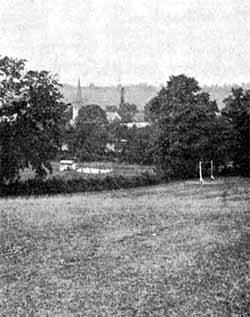
VIEW OF VILLAGE FROM MILL HILL.
In passing from the chequered history of Anglo-Saxon times, it is natural to ask, whether we have any visible means of recalling that history. It may be pointed out that the Court Hill, where the business of Rushcliff Hundred was transacted, is known. Thoroton says:—“On the North side of this Lordship, on a knoll called Court Hill near the bounds of Gotham, about a flight shot from Cuckoo Bush the Hundred Court hath been kept.” The ordnance map marks this spot, to which Leake representatives were periodically summoned for the local Parliament.
It is suggested that in the field name, “The Motts,” is indicated the place where the Moot Court—the parish meeting of Anglo-Saxon days—was held. In Anglo-Saxon, mot means meeting. Here probably the freemen met for judgment, to make laws for the community, to choose their leaders, and the men who should follow their headman to the Hundred Court or to war.
It is tempting to explain the old custom of frequenting Mill Hill on Shrove Tuesday, as a continuation of some heathen custom, connected with the worship of the ancestral false deities. The same custom is met with at Costock and elsewhere—pointing to some general rather than local custom.
Many of the field, hill, and road names in the parish are Anglo-Saxon. The chapter on Field Names will furnish examples of Anglo-Saxon and Danish words.
The account of the Church will be found to suggest that in that one venerable building of the parish an Anglo-Saxon story can be read in stone.
1 "Words and Places," p. 167.